Caminito del Rey – tickets, map, directions, parking
A double dose of adrenaline
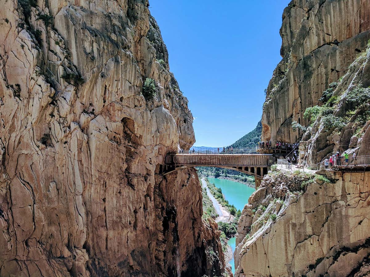
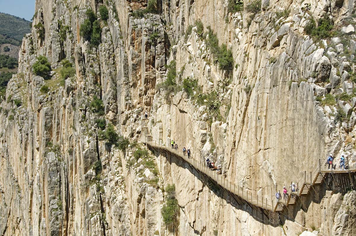
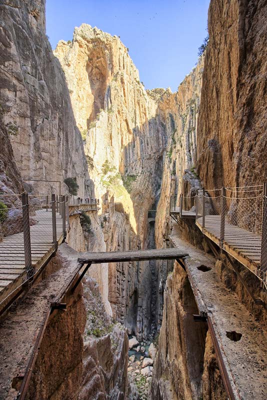
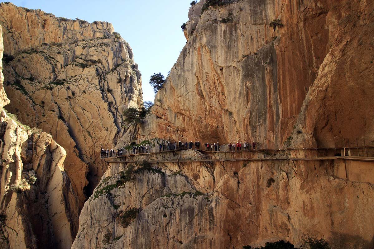
This is how you can briefly describe visiting Caminito del Rey: a double dose of adrenaline. The rocky areas create amazing scenery. The steep, constricting walls of the gorge and the dizzying cavernous cliffs create something that causes a powerful and pleasant adrenaline rush. This unique product of nature absolutely amazes, and each subsequent step changes the viewing angle, constantly creating new, amazing images. Just when you start to think that it can't get any more beautiful, the next step forces you to change your mind. Walking along the most spectacular parts of the trail is like watching a movie composed of only outstanding frames, only the best photos, only shots worth an Oscar.
You get a second dose of adrenaline when you look at your feet and remember that while looking at these beautiful views, you are standing on a narrow footbridge over a precipice, and under your feet there is a precipice of over 100 meters.
This is the most exciting part of the walk The King's Path i.e. Caminito del Rey. A walk you will talk about for the rest of your life.
Where the king walked
The history of the path's creation is quite prosaic, and its today's function as one of the most desirable tourist attractions is just an unplanned side effect after abandoning its proper purpose.
The construction of the path was necessitated by works related to the implementation of planned hydrological facilities on the Guadalhorce River flowing here. During the works, there was a need to create a relatively easy road connecting both ends of the gorge, serving for the movement of employed people and the transport of goods. In this way, a path suspended on the walls of the gorge was created.
The unique landscape values it offered made someone come up with the idea to lead the King of Spain, Alfonso XIII, along this path after the construction of the Conde del Guadalhorce dam was completed. The king took advantage of the offer and reportedly covered the entire path on his own feet. To commemorate the fact that this is the place where the king walked, the path was named: Caminito del Rey, or the King's Path.
Then, for many years, it basically fell into oblivion, gradually deteriorating, until it reached a state of ruin that was dangerous to life. Then came daredevils looking for unique emotions, who, using mountaineering protection, wanted to overcome the dangerous path while enjoying unique views.
See the video from walking along the path before the renovation:
Unfortunately, extreme expeditions did not always end happily and serious and even fatal accidents began to occur on the path. Over time, the path gained the reputation of the most dangerous, extreme rock trail. Paradoxically, its gloomy fame began to attract more and more people eager for extreme experiences. This must have ended tragically. The years 1999 and 2000 saw four fatal accidents and then the local authorities decided to permanently close the trail. In order to effectively prevent access to the trail, long sections of the path and platforms at its ends were destroyed, high fines (EUR 6) were introduced for attempting to enter the remains of the trail, and surveillance was launched to detect unauthorized attempts to enter the trail.
The trail remained closed for 15 years, but the region's authorities were well aware of its tourist potential. In 2014, at a cost of EUR 7 million, a new, fully safe path was renovated and built (the old fragments were left in place as a souvenir) and now we can fully enjoy its charms without risking our health or life.
Where is Caminito del Rey?
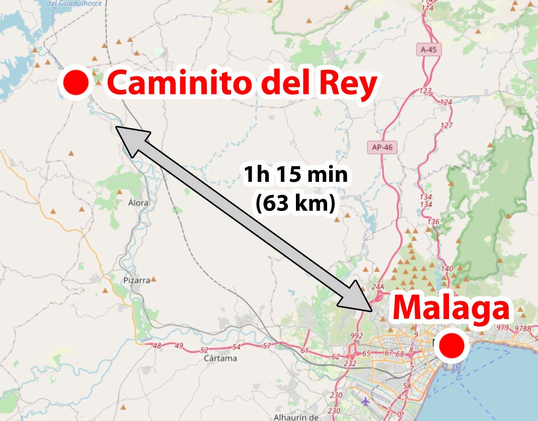
The King's Path is approximately 63 km away Malaga and is currently one of the biggest attractions Andalusia. The easiest way to get here is by car or train from Malaga to the station El Chorro-Caminito del Rey. On page OMIO – [click] you can check current connections and buy train tickets online.
Location of Caminito del Rey relative to Malaga is presented in the map below.
Caminito del Rey tickets
And everything would be nice if not for the problem that appeared immediately after the path was made available for sightseeing. There are several times more people willing to see it than there are tickets available. For safety reasons, the number of people who can be on the path at the same time is severely limited. Tickets are therefore purchased for a specific day and time. Entry outside designated hours is not possible. The trail is accessed in groups under supervision. However, you don't have to go with the whole group. There is no problem in staying a bit behind, disconnecting slightly from the group and walking at your own pace (especially on hanging platforms). You can then take nicer photos.
The limited number of tickets means that you have to buy them well in advance, and purchasing them on the spot, although theoretically possible, is unlikely to succeed in practice. Tickets usually sell out weeks in advance.
So if the King's Path is important to you and you really want to see it, get your entry tickets in advance. You can do this by ordering them online.
Below are two sources. The first one redirects to the ticket distributor, and the second one to an organized group tour. A large part of the entrance tickets are reserved by the organizers of group tours and if individual tickets are not available, joining an organized group that has guaranteed entry may be a solution. Group tickets from external organizers are usually a little more expensive (you have to pay a guide), but often include, for example, round-trip transport from Malaga (no need to rent a car) or other attractions.
See the available options and choose the best solution for you.
check out: availability of tickets to Caminito del Rey – [click]
check out: organized trips to Caminito del Rey – [click]
ATTENTION !!!
Children under 8 years of age are not allowed on the trail, even if accompanied by their parents!
Caminito del Rey tour and map
Entry (Acceso Norte) to the King's Path is in a completely different place than the exit from it (Acceso Sur). The entrance and exit are over 7 km away. If you come here as part of a group trip, the travel organizer will probably solve the transport problem for you.
If you choose the option of exploring on your own and arrive at the place in your own car, you can organize the tour in several ways.
To make it easier to explain the matter, I have prepared a special map presenting it route of the trail (red dots), location of parking lots cars (parking symbol) and route of the bus line along with stops (green dots and square BUS symbols).
Further in the text you will find precise GPS coordinates of all important points visible on the map. Use them! There is a link next to the GPS coordinates. Clicking on it will open the navigation in your phone and automatically calculate the route to or from your current location. Simple, and it makes life a hell of a lot easier. I recommend!
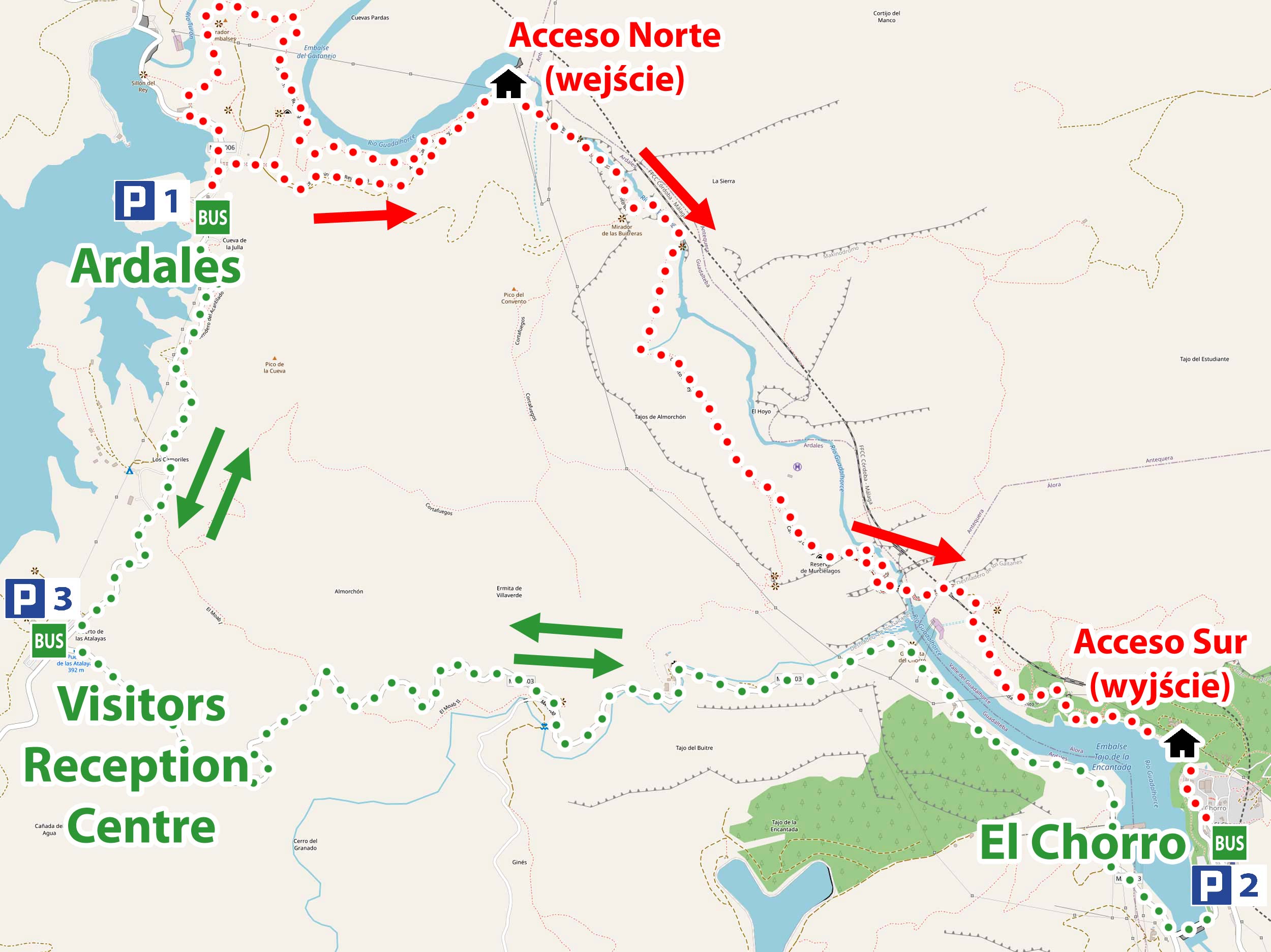
As you can see on the map, there are three parking lots near Caminito Del Rey. There is also a bus stop at each parking lot, which runs between the exit and entrance to the trail.
The entrance and exit from the trail are marked on the map with a black house icon. Please note that it is still a short walk from the bus stop to the trail entrance. The time of entry to the trail given on the admission ticket is the time at which you must be at the black house (Acceso Norte) marked on the map.
You can take two different routes to the entrance to the trail (Acceso Norte) (both marked on the map):
- shorter route (Pista de Gaitanejo) has length 1,5 km (20 min) and starts with a tunnel right next to the asphalt road. I have provided the precise GPS coordinates of the beginning of the route below.
- longer route (Senda de Gaitanejo) has a length 2,7 km (40 min) and starts through a tunnel next to the restaurant The Kiosk. I have provided the precise GPS coordinates of the beginning of the route below.
The closest parking lot to the trail entrance is P1, but it is not able to accept all cars. When you get there, you may find that there are no available seats. When planning to park in this parking lot, leave yourself some time to look for a free space somewhere else.
Parking lot P2 is located near the trail exit. If you park your car here, you must wait for the shuttle bus and take it to the trailhead. So arrive at the parking lot about 1,5 hours before the time you plan to enter the trail. After crossing Caminito del Rey, you will exit the trail near your car.
The largest parking lot is P3. It takes about 15 minutes to get to the trail entrance. Therefore, it is worth being there about an hour before the planned time of entering the trail. After completing the trail, you need to take a bus that will take you to the parking lot.
A ticket for the shuttle bus costs EUR 2,5 and is valid for the whole day. People leaving their car at the P3 parking lot and going to take the bus twice do not have to buy two tickets. One ticket is valid for both journeys (the ticket is valid for the whole day).
You can buy a ticket from the driver and pay only in cash.
Useful GPS coordinates
Parking lot P1 and bus stop (Ardales), GPS coordinates:
36°55’43.9″N 4°48’06.4″W
36.928868, -4.801772 - click and route
Parking lot P2 and BUS stop (El Chorro), GPS coordinates:
36°54’24.4″N 4°45’33.1″W
36.906777, -4.759200 - click and route
P3 parking lot and BUS stop (Visitors Reception Center), GPS coordinates:
36°54’51.6″N 4°48’27.2″W
36.914324, -4.807561 - click and route
Tunnel to the Caminito del Rey trail (shorter route), GPS coordinates:
36°55’47.9″N 4°48’02.3″W
36.929967, -4.800648 - click and route
Tunnel to the Caminito del Rey trail (longer route), GPS coordinates:
36°55’53.9″N 4°48’06.2″W
36.931625, -4.801731 - click and route
Something else?
Yes! If, after crossing Caminito del Rrey, you still don't have enough attractions and you have a car, you can still drive to a very interesting viewpoint of the local backwaters (Mirador de Tres Embalses). A nice place, beautiful views and a good place to stop for a moment and just look ahead.
Mirador de Tres Embalses viewpoint, GPS coordinates:
36°57’00.6″N 4°48’01.8″W
36.950161, -4.800512 - click and route
Parking lot at the Mirador de Tres Embalses viewing point, GPS coordinates:
36°57’03.7″N 4°48’02.8″W
36.951013, -4.800770 - click and route
Accommodation near Caminito del Rey
The choice of accommodation near Caminito del Rey is not large, but you can find some interesting options at a good price. Below you will find three accommodations of my choice. Please do not use these as a specific indication of the hotels I recommend. Treat them as a good start for further exploration. The links I posted use the search engine mechanism, which, next to a specific hotel, always offers other, similar offers, often with more attractive prices. I recommend using these links because they make your search easier and save time.
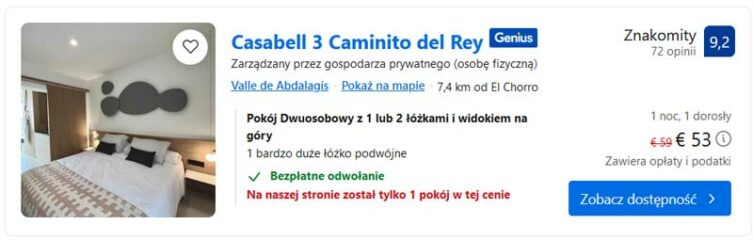
Casabell 3 Caminito del Rey – [click]
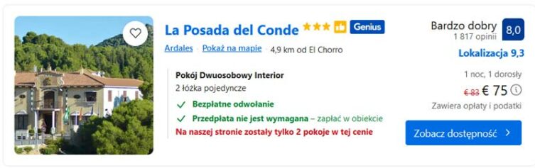
La Posada del Conde – [click]
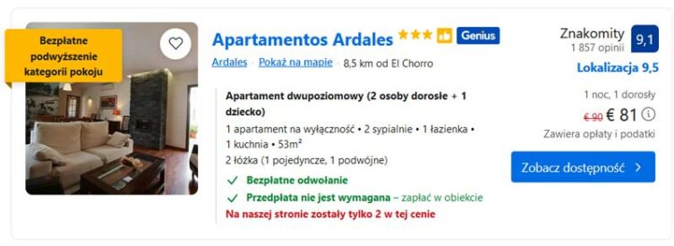
Apartamentos Ardales – [click]
Important to me!
Give the article a good rating (5 stars welcome 😀)!It's free, a for me it is very important! The blog lives on visits and thus has a chance to develop. Please do it and ... thank you in advance!
If you like my guides, you will certainly find the one I created useful guide catalog - [click]. There you will find ready-made ideas for your next trips, descriptions of other tourist destinations and an alphabetical list of guides divided into countries, cities, islands and geographical regions.
I also post link to Facebook profile - [click]. Come in and press "Follow"then you will not miss new, inspiring posts.
Unless you prefer Instagram. I'm not a social media demon, but you can always count on something nice to look at on my instagram profile - [click]. The profile will gladly accept any follower who likes it.
I make the content I create available free of charge with copyright, and the blog survives from advertising and affiliate cooperation. So, automatic ads will be displayed in the content of the articles, and some links are affiliate links. This has no effect on the final price of the service or product, but I may earn a commission for displaying ads or following certain links. I only recommend services and products that I find good and helpful. Since the beginning of the blog's existence, I have not published any sponsored article.
Some of the readers who found the information here very helpful, sometimes ask me how you can support the blog? I do not run fundraisers or support programs (type: patronite, zrzutka or "buy coffee"). The best way is to use links. It costs you nothing, and support for the blog is self-generating.
Pozdrawiam