Tuscany – map, attractions, sightseeing plan, trips, the most beautiful places
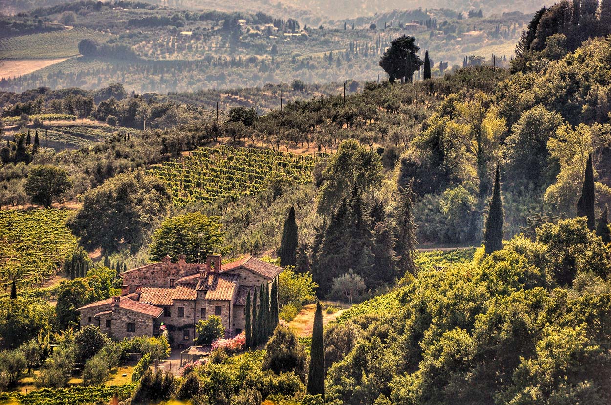
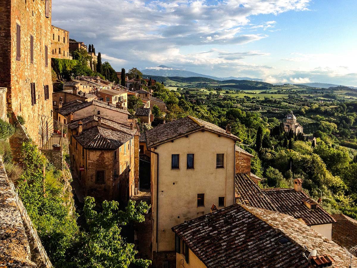
The most beautiful landscape in the world
These are the words that will greet you on the official website of the Val d'Orcia valley in Tuscany, inscribed on the UNESCO list for its landscape values: the most beautiful landscape in the world. Undoubtedly, in Tuscany you will find a lot of wonderful scenery and more than once, when you see them, you will have to sigh with delight or stop for a moment to look a little longer, to preserve a fleeting moment in your memory. But this is just the beginning!
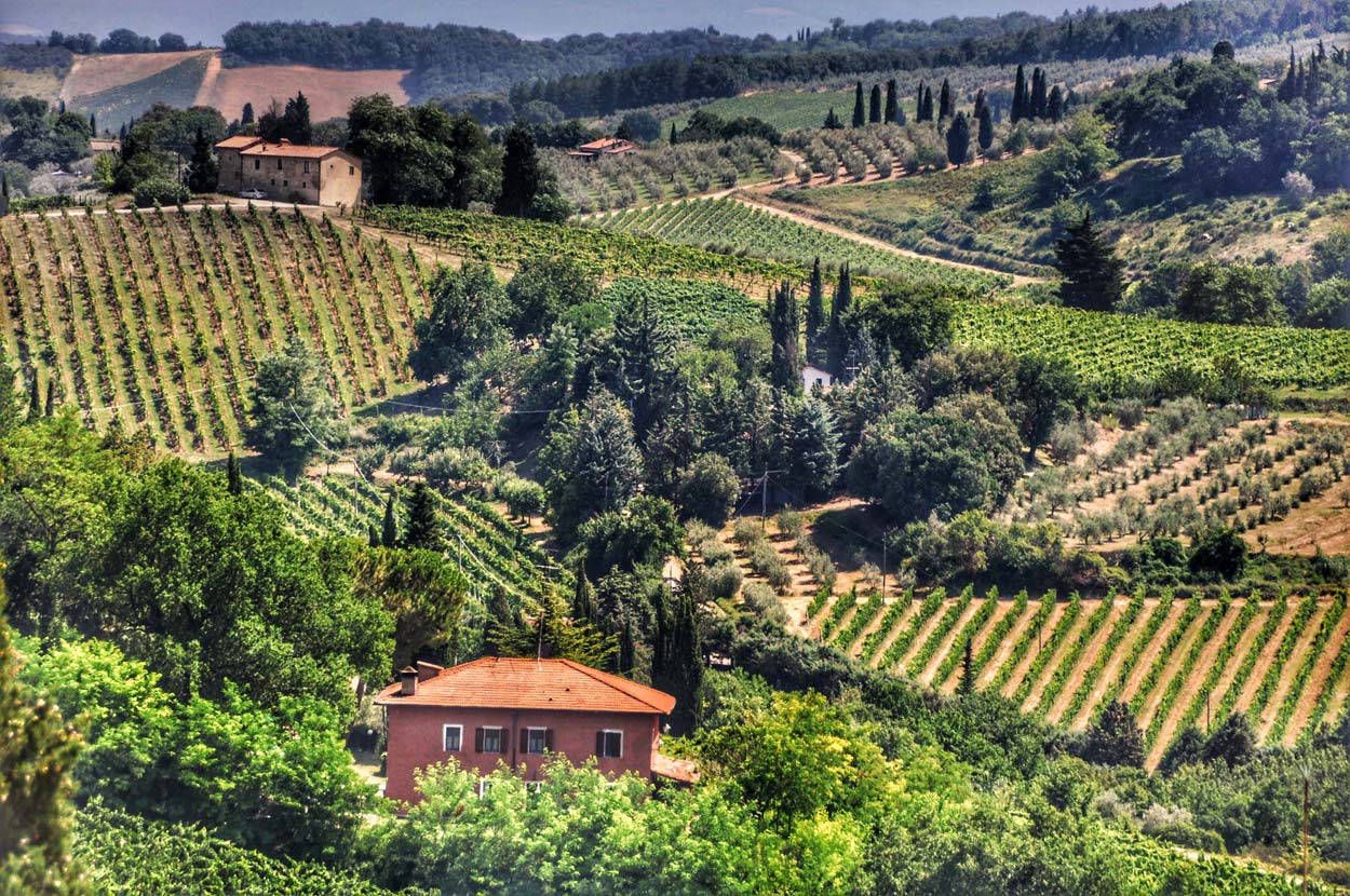
Among the Tuscan landscapes there are small medieval towns with a brilliant atmosphere, vineyards, olive presses, and thousand-year-old trails that were once traversed by travelers and merchants, and today can be walked by tourists. You will also discover here larger centers of culture, art and science with age-old universities, where the foundations of our modern knowledge and works that are today considered the greatest human achievements were created. All this is supervised by the capital of the region: Florence. A city that sparkles and exudes power, panache and seductive beauty. Nowadays, it is still the world's largest center for trade in gold and precious stones. This is where huge capitals meet and cross major routes to strike deals in the trade of luxury goods. This is what Tuscany is like!
The best guide in the world
Without exaggeration! This will definitely not be the world's best guide to Tuscany. However, it will be very practical and, I hope, really useful.
Visiting Tuscany usually comes down to a very difficult choice: what to see? Unfortunately, you can't see everything at once! You have to choose. This entry will definitely make your life much easier. It contains only the greatest attractions of this region. However, I warn you that when moving between the places I have selected, you will pass dozens of other, equally interesting places. The road will be full of beautiful views, countless vineyards, olive groves, presses and farms selling their own products (brilliant pasta, olives and balsamic vinegars). If something catches your attention while traveling between subsequent points of the itinerary, do not hesitate to change your plans. The freedom to explore and satisfy your curiosity in Tuscany is the best thing you can do. Stop, try, test and taste.
I have prepared this guide in such a way as to leave you plenty of space for your own experiences and modifications. I think this is the best way to fully feel this extraordinary region of Italy.
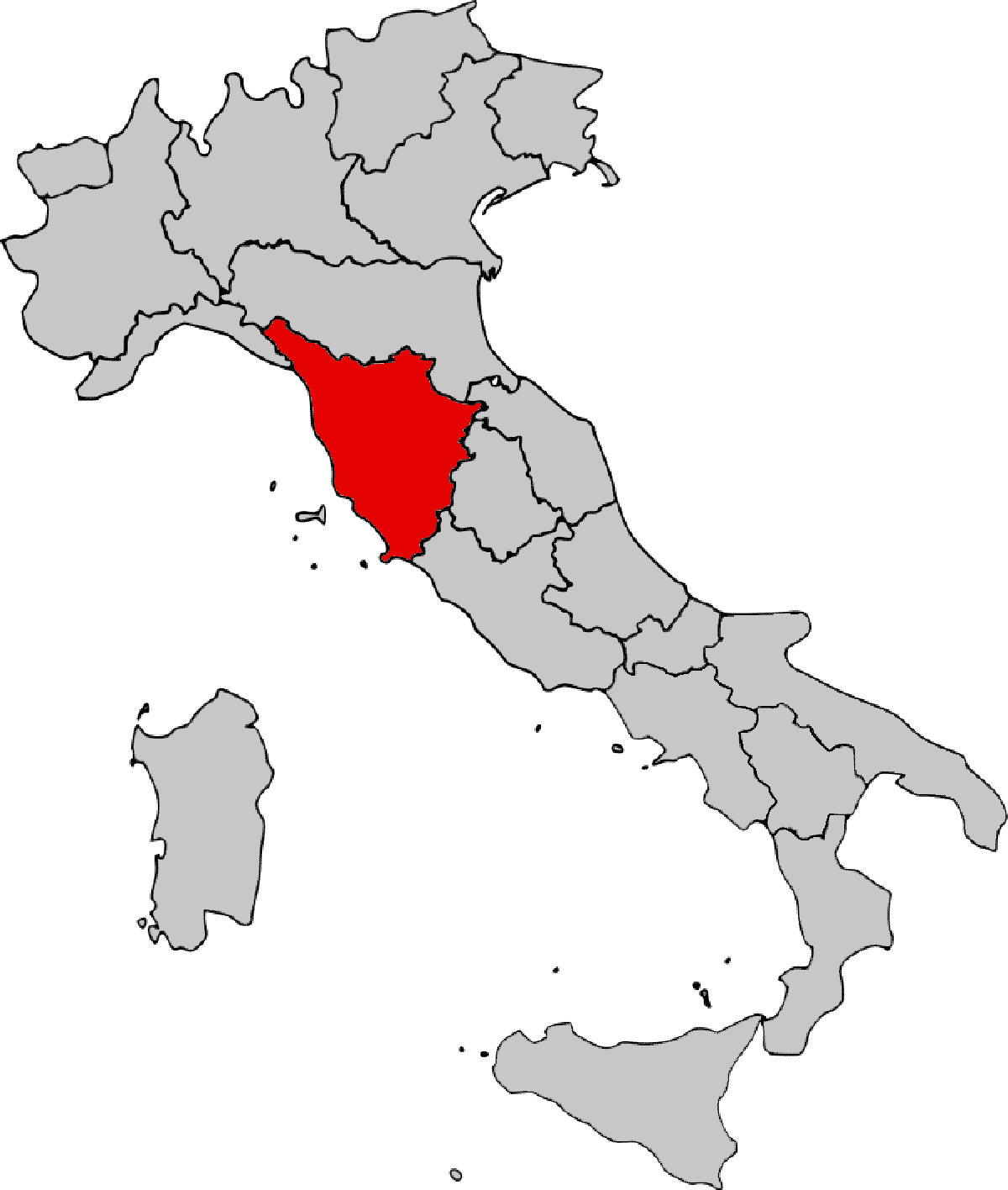
Where is Tuscany?
Italy is divided into 20 regions, one of which is Tuscany. The maps attached below present the location of Tuscany against the background of the map of Europe and the map of Italy.
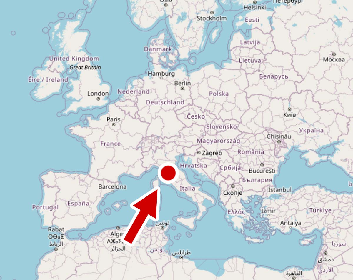
Looking at the maps, you can immediately notice the very favorable location of Tuscany for tourists. It is easily accessible from most countries in Europe by land, and those arriving by plane have at their disposal the Florence Peterola airport (Aeroporto di Firenze) and several airports located a short distance from Florence, served by low-cost airlines:
– Pisa Galileo Galilei airport (70 km from Florence),
– Bologna Guglielmo Marconi airport (85 km from Florence),
– Rimini Miramare airport (112 km from Florence).
Statistically, Tuscany is one of the largest regions in Italy. In terms of size, it is in fifth place, second only to Sicily, Piedmont, Sardinia and Lombardy.
This does not mean, however, that traveling in Tuscany will involve long journeys.
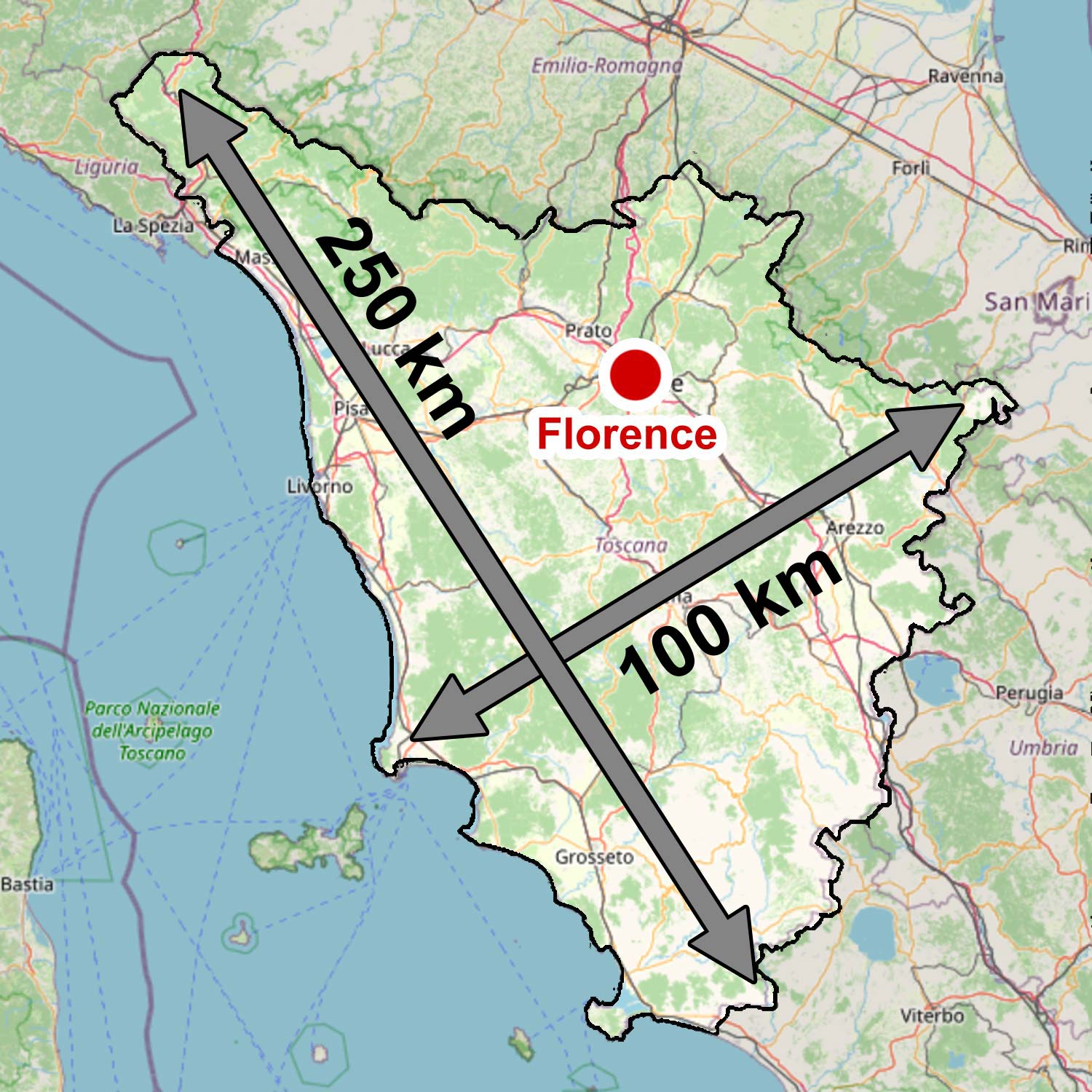
Generally, Italian regions are small in size, and even Tuscany, which is quite large by Italian standards, is in practice a size that is perfect for sightseeing.
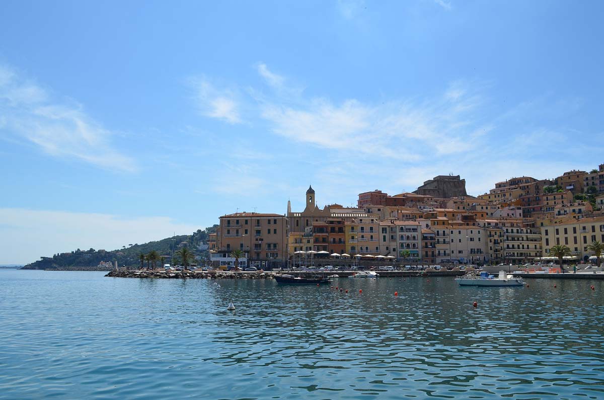
A sensibly designed plan will allow you to significantly reduce the length of necessary journeys and leave plenty of room for the pleasures of active sightseeing. Days during which you will have to travel more than 150-200 km will be rare.
How to visit Tuscany?
To put it briefly and concretely, there are basically two sensible ways to explore Tuscany: public transport or a rented (or your own) car.
Public transport
Tuscany is well connected, so moving between the main centers should not be a major problem or challenge. It will, of course, take more time and introduce several restrictions, mainly related to the need to adapt your activities to timetables, but it will allow you to reach the most important places.
In this guide, I won't focus on describing public connections because I haven't used them myself. So I won't talk about something I haven't tested in practice.
The website can significantly facilitate the organization of trips for people interested in this form of travel Omio – [click], which allows you to check timetables, bus, train, air and ferry connections.
Own car
If possible, I always rent a car. I value the freedom and independence that having my own means of transport guarantees me. Thanks to this, I am not limited to looking for accommodation near transport hubs or the time in which I have to return to the hotel to catch, for example, the last connection.
Sometimes I choose accommodation outside the city in agritourism, which at good prices can provide me with much greater comfort. At the same time, being slightly away from the main tourist traffic, it is much easier to feel the local atmosphere. I love sitting somewhere in the countryside having dinner with a view of the hills over which the sun is just setting and leisurely sipping local wine.
So I definitely recommend having your own means of transport. If you live so far away that you can't get here by car, just rent a car at the airport. I have prepared a special article about renting a car in Italy guide – [click]. With my guide, renting a car is not difficult or complicated, and at the same time it is very safe (the matter of choosing insurance). You just need to know how! I encourage you to read it: Italy – car rental without deposit and credit card [GUIDE]
Tuscany – attractions map
The main starting point for building a tour of Tuscany should be the map of Tuscany below, on which I have marked the location of all the attractions.
It's worth spending some time looking at it and checking the location of the places that interest you the most. If you click on the map, a higher resolution image will open with more details (routes, names of nearby towns, etc.)
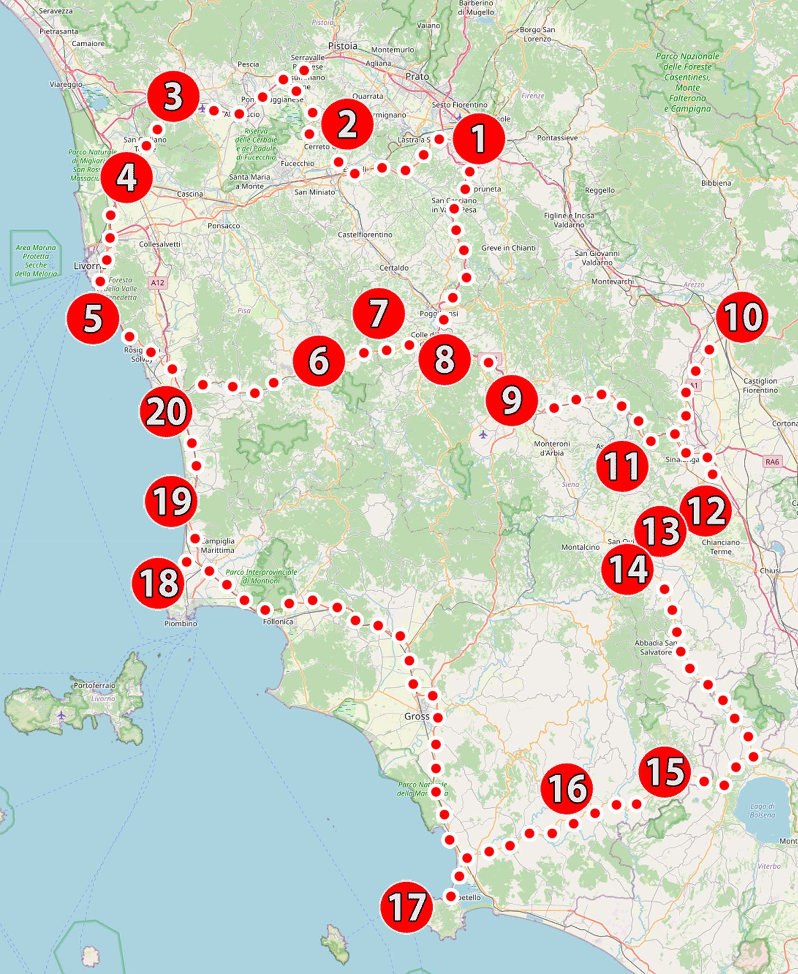
List of tourist attractions on the map:
1. Florence
2. Vinci
3. Lucca
4. Pisa
5. Calafuria
6. Volterra
7. San Gimignano
8. Monteriggioni
9. Sienna
10. Arezzo
11. Val d'Orcia
12. Montepulciano
13. Pienza
14. Bagni San Filippo
15. Pitigliano
16. Terme di Saturnia
17. Monte Argentario
18. Baratti Bay
19. Marina di Castagneto Carducci
20. Marina di Cecina
Each attraction has its own unique number. You will also find this number in the table of contents at the beginning of the guide and in the chapter headings related to a broader description of attractions. Each attraction I mentioned has its own description, containing more details, interesting facts and very useful ones GPS coordinates of important places and parking lots, making it very easy to reach them. Use this data! They are very simple to use. Just click on the link next to them, a navigation on the phone will start automatically and will calculate the route to your destination (just don't forget to switch the navigation from walking mode to driving mode or vice versa).
Some of the attractions, in addition to the brief information in this entry, have their own articles devoted to them, containing a large amount of data and advice. Links to them (if such extended entries exist) can be found in the short descriptions attached later in the guide.
Work on extended descriptions is still ongoing, so the number of links will increase.
Tuscany sightseeing plan
When working on the Tuscany tour plan, I tried to prepare it in such a way that it would be useful to as many people as possible. I would like it to be able to be used by novices who are going to this area for the first time in their lives, but I also wanted it to be useful for people who have already seen something in Tuscany.
This created a concept that the more I thought about it, the more I liked it. Why? Because, apart from the fact that it is suitable for people with varying degrees of advancement in visiting Tuscany, it also allows for flexible adjustment of the duration of the trip to the length of the holiday.
So what is my plan? Divided Tuscany into several convenient areas to explore! Everything will be explained to you in the next chapter.
Visiting areas
Look at the map below. This is exactly the same map of attractions that we already know from this entry, but I applied a specific mask to it, separating several areas marked with letters: A, B, C, D i E.
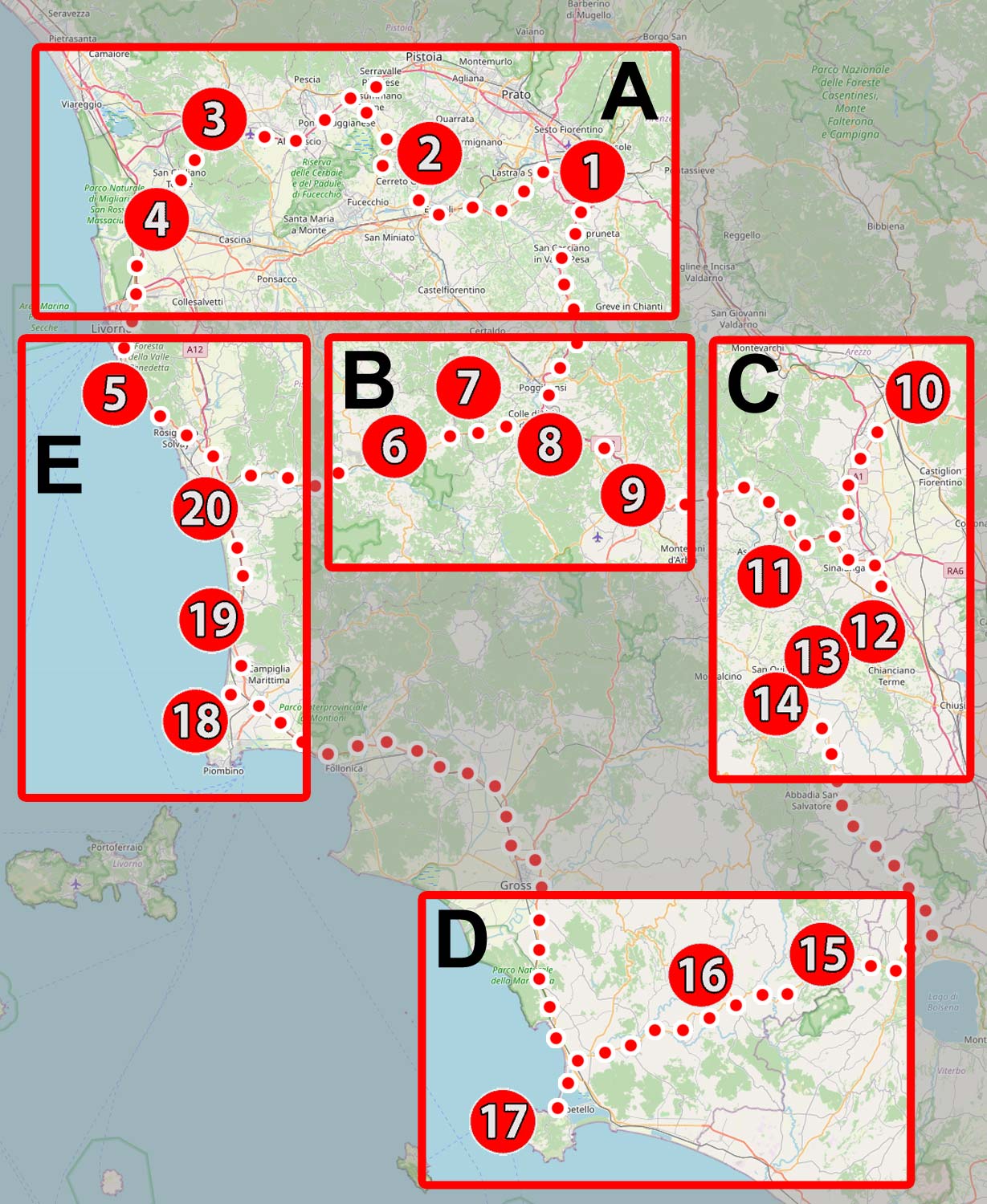
It is easy to name each area directly after the most important attractions in its area. So we have:
Distance A – around Florence and Pisa
Distance B – around San Gimignano and Siena
Distance C – Val d'Orcia (Orcia river valley) and Crete Senesi (desert area)
Distance D – south of Tuscany
Distance E – Tuscan coast
The areas include areas that do not overlap with each other, but they all have one common and very important feature: Two days are enough to visit each of them, or even more precisely, two nights.
Approaching the matter in this way, planning a visit becomes very easy. Just choose the areas that interest you the most and, knowing that you need to spend at least two days on each of them, choose their number according to the length of your vacation. Ready!
However, before you decide which areas to choose, read a few words about the content each of them offers!
Area A – around Florence and Pisa
All attractions in the area: (1) Florence – (2) Vinci – (3) Lucca – (4) Pisa
Total length of the route: approximately 120 km
Stravel time agreement (without visiting time): 2 h 30 min
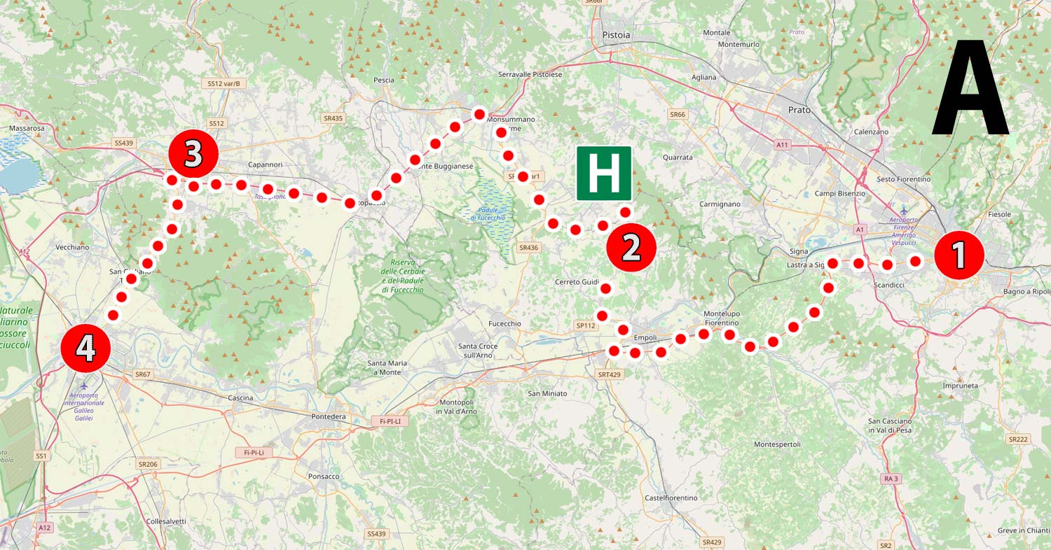
Just a few sentences earlier, I had optimistically assumed that two days would be enough to visit each area, but suddenly... area A the first problems appear. It's true that there are only four locations planned here, but what!!! I don't need to introduce Florence. The city will definitely take you all day to explore. If you decide to stay overnight in one of the other locations (we stayed near Vinci, specifically in the small town of San Baronto, where we have inexpensive but comfortable Hotel Monti, which we have been eagerly returning to for years, I marked its location with a green pictogram with the letter H), then the next day you can start visiting Vinci (2) in the morning, where Leonardo da Vinci was born and lived. Then Lucca (3) with its fantastic buildings, oval market and observation tower, and in the evening you will reach the legendary Pisa (4) to see how lean the world-famous tower is. If you plan an overnight stay in Pisa (4), you will have the opportunity to see it during the day and at night, under the glow of artificial lighting. As you can easily guess, this is an additional attraction. I am considering this idea.
Most trips in this area will be on fast roads, so it will be difficult to get beautiful views from the car, but there will be time for that.
Area B – around San Gimignano and Siena
All attractions in the area: (4) Pisa – (6) Volterra – (7) San Gimignano – (8) Monteriggioni – (9) Siena
Total length of the route: approximately 150 km
Total travel time (without visiting time): 3 h
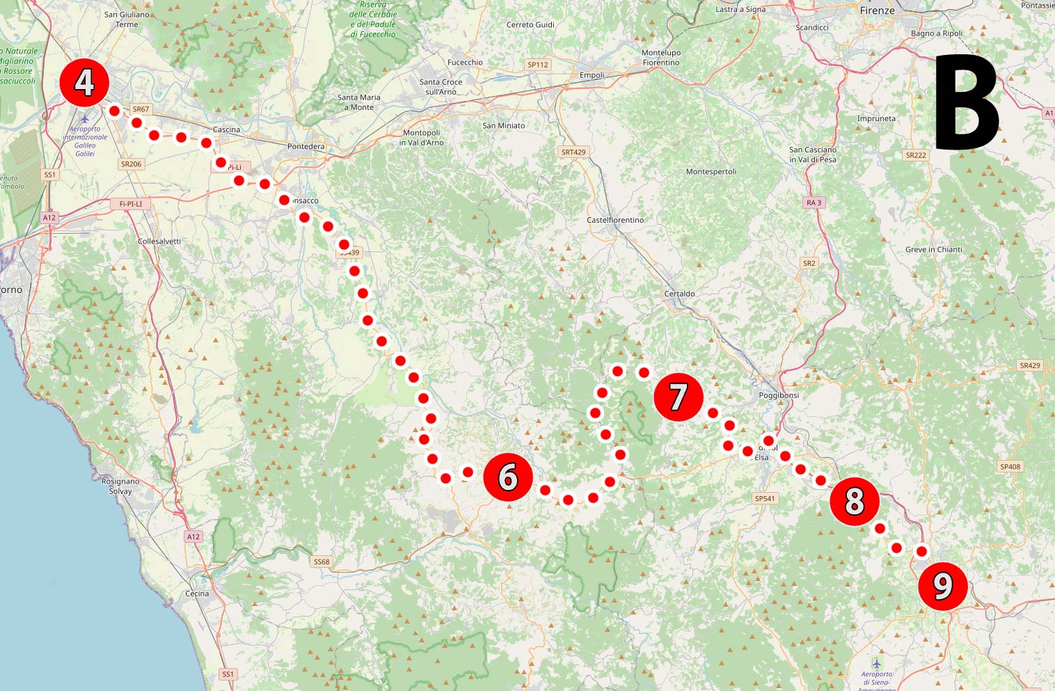
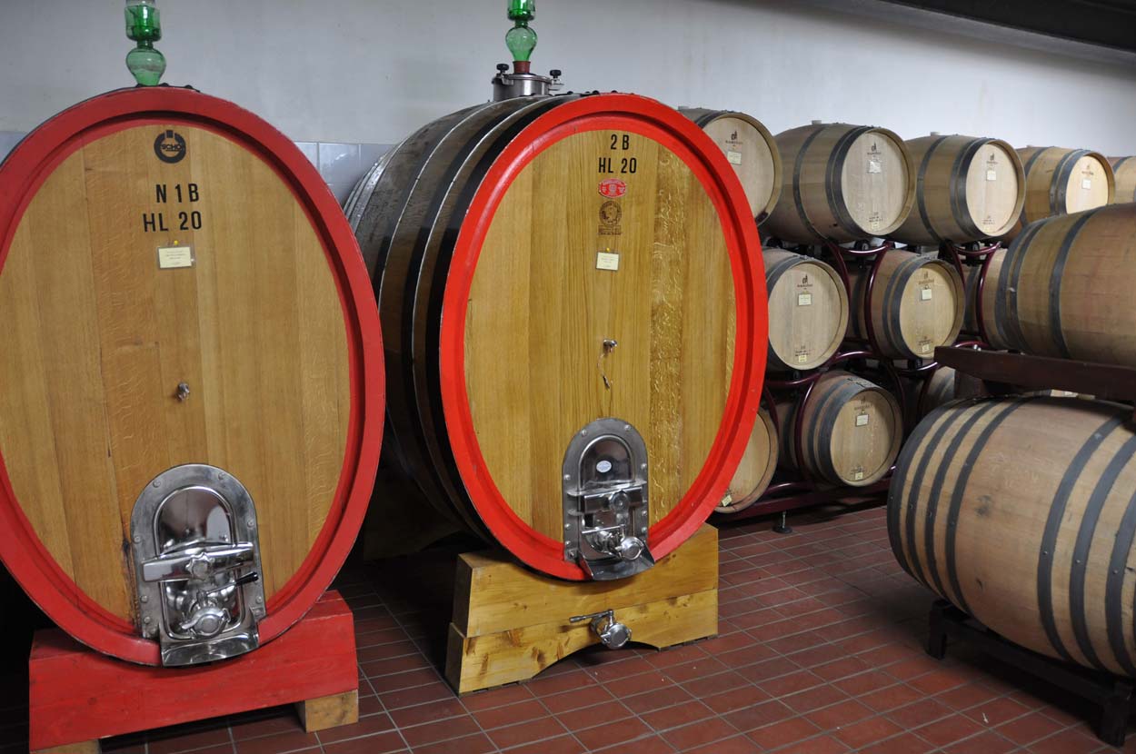
The second area is the quintessence of Tuscany, where you will begin to discover subsequent towns that will appear unexpectedly among the rolling Tuscan hills, surrounded by vineyards and olive groves. Every now and then you will see signs inviting you to visit subsequent vineyards to taste and purchase selected products. Don't be afraid to visit vineyards and olive presses. The hosts will be happy to welcome you and sometimes show you around their kingdom, among large barrels of fermenting and maturing wine. The experience is wonderful, and a souvenir in the form of purchased wines is perfect when, after returning home, on an autumn or winter evening, it is time to remember the trip. The taste of the original wine perfectly helps recall sunny memories.
Between the vineyards you will come across medieval towns whose delightful, narrow streets will lead you by the hand. San Gimignano, Volterra, Monteriggioni, and finally the absolutely brilliant Siena. It's hard to imagine a more beautiful set!
By the way, I would like to remind you that when traveling from one attraction to another, you do not have to choose the shortest or fastest route!

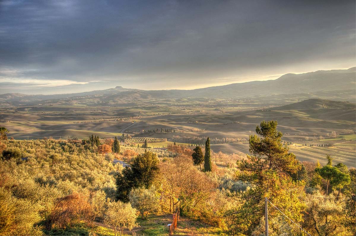
Area C – Val d'Orcia (Orcia Valley) and Crete Senesi
All attractions in the area: (9) Siena – (10) Arezzo – (11) Val d'Orcia (12) – Montepulciano – (13) Pienza – (14) Bagni San Filippo
Total length of the route: approximately 210 km (without exploring the Val d'Orcia valley)
Total travel time (without sightseeing time): 3 h 45 min (without exploration time in the Val d'Orcia valley)
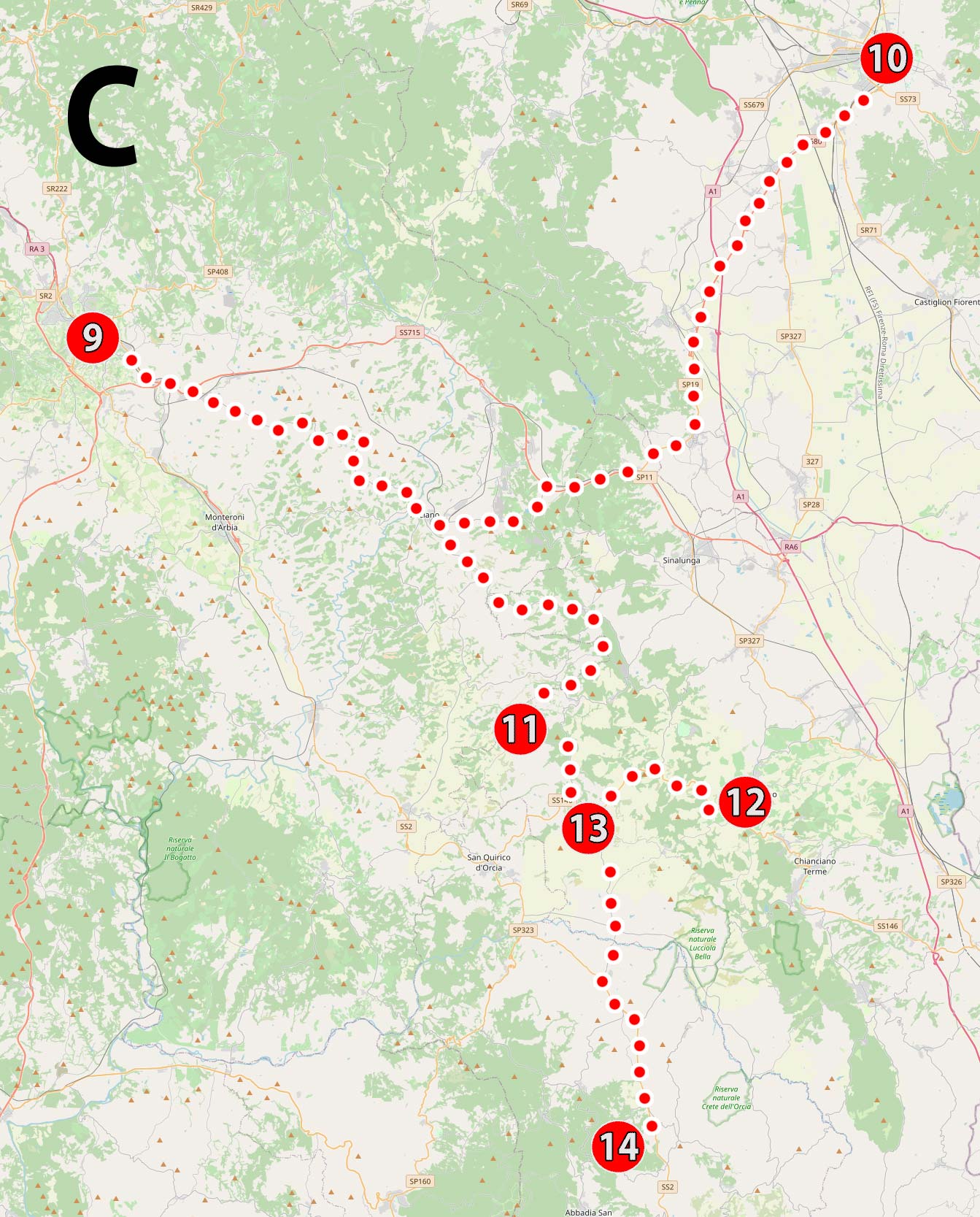
The third area is the next stage of getting to know the diversity that Tuscany offers us. A real nature rollercoaster!
Apart from interesting towns, we will focus on landscapes that we all know from exceptionally beautiful postcards, presenting vast, gently rolling hills illuminated by the rising or setting sun. We will look for the world-famous cypress formations and avenues typical of this landscape, but before that we will pass through the Crete Senesi area, which is the only Italian… desert! We will travel from the harsh Tuscan desert to the Tuscan greenery of vineyards and olive groves.
Finally, we will reach the first hot springs and thermal springs on the route of this trip, creating colorful waterfalls.
I suggest devoting one of the two days intended for visiting this area to a full-day wander around the valley. Val d'Orcia. Your imagination, willingness to look literally everywhere, and driving on roads that are not connected to navigation will be especially important here :)
Area D – south of Tuscany
All attractions in the area: (14) Bagni San Filippo – (15) Pitigliano – (16) Terme di Saturnia – (17) Monte Argentario
Total length of the route: approximately 140 km
Total travel time (without visiting time): 3 h
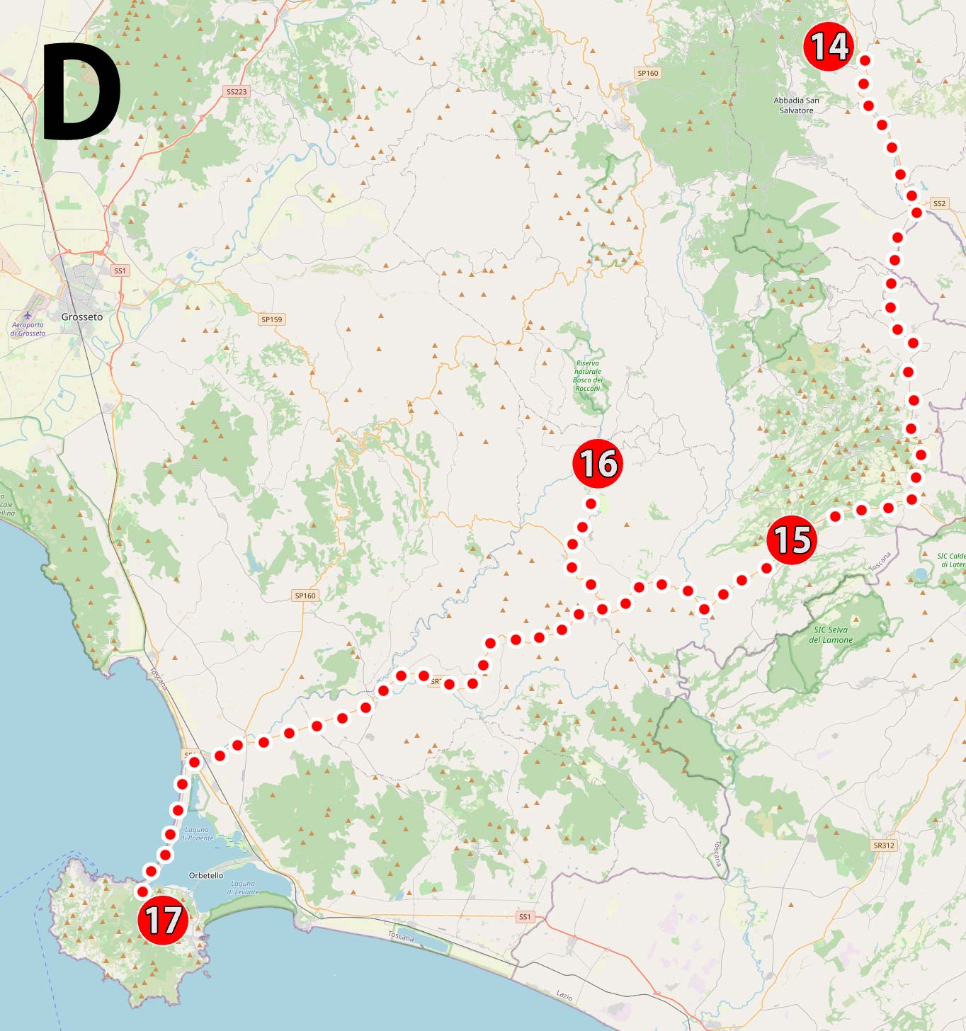
This time we will visit another very eye-catching and beautifully situated town, and further along the way we will be able to relax in the famous Saturnia thermal baths (you can use a high-quality resort with swimming pools or simply enjoy the amazing, natural swimming pools). At the end of the trip, we will reach the Tuscan coast, specifically the interesting Monte Argentario peninsula, which once... was an island! This is where the slightly lazier part of the trip begins :)
Area E – Tuscan coast
All attractions in the area: (17) Monte Argentario – (18) Populonia and the Gulf of Baratti – (19) Marina di Castagneto Carducci – (20) Marina di Cecina – (5) Calafuria
Total length of the route: approximately 210 km
Total travel time (without visiting time): 3 h 20 min
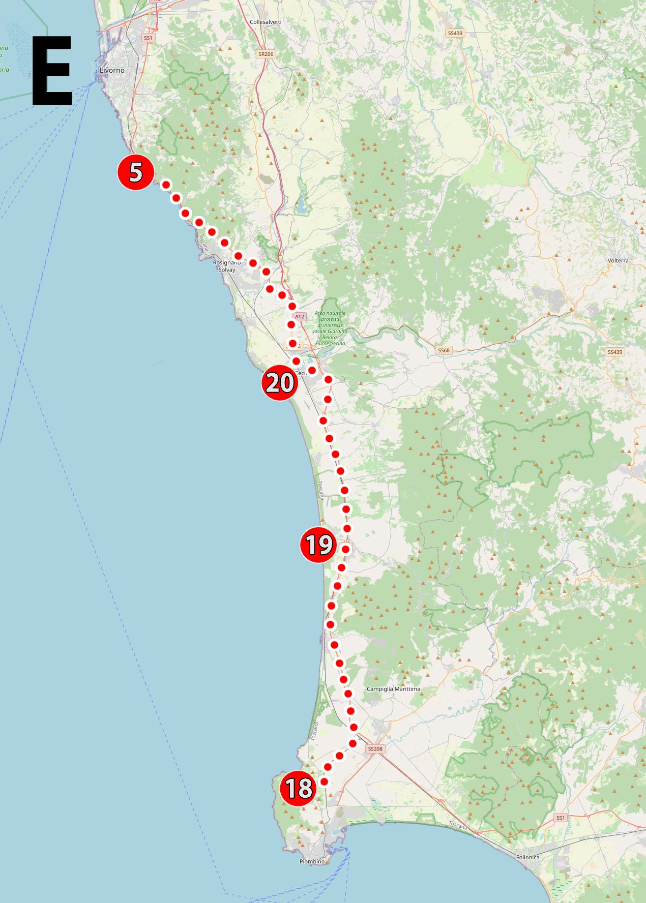
In the case of the last area, it is difficult to talk about sightseeing, although there are also such places (e.g. the extremely interesting Populonia). It should be treated rather as an opportunity for a short rest after a long and intense sightseeing and before returning home. If someone has a restless spirit, they can treat the beaches I have suggested as trip points that are an excuse to get to know the Tuscan coast. A particularly interesting part of the rugged coastline, on which you can even take a short walk, is located between Quercianella and Calafuria (5).
I guess that some people, contrary to me, will place this area not at the end, but at the very beginning of the trip and... they won't leave it anywhere 😀
This is possible, and even very likely, especially since some of the attractions in areas A, B and D are within reach of one-day trips from the Tuscan coast.
Yes Yes!!! I know that a plan is already forming in your head: what about lying on the seashore and just going inland from time to time to see something? This may also be an interesting proposition, and thanks to this entry you will be able to develop such a plan on your own quickly and without much effort!
I encourage you to experiment on your own! As you can see, there are many possibilities and there is no one best plan for visiting Tuscany in the world... as I loyally mentioned at the beginning.
Descriptions of attractions in Tuscany
Below you will find really short descriptions of all the attractions visible on the map of Tuscany. I include GPS coordinates of key points in the descriptions, including parking lots allowing you to stay near the attractions. I encourage you to use them. Every driver will appreciate such convenience. You click your finger, the navigation starts automatically and you're on your way.
For each attraction, I also include a link to accommodation. The links provided contain filters I have prepared. They prevent the display of offers that could unnecessarily clutter the search results and appropriately narrow the search area to the area that interests us. So you don't have to do it manually every time. I recommend using these links because they make your search easier and save time.
For some locations, I will also include links to hotels. Do not treat them as a recommendation of a specific hotel. When posting a link to a hotel, I use the search engine mechanism, which, next to the selected hotel, always suggests several alternative accommodations with similar parameters (location, quality, and often a more attractive price, etc.). So treat them as a very simple way to search for and compare many offers from one place with one click. Smart and effective.
1. Florence
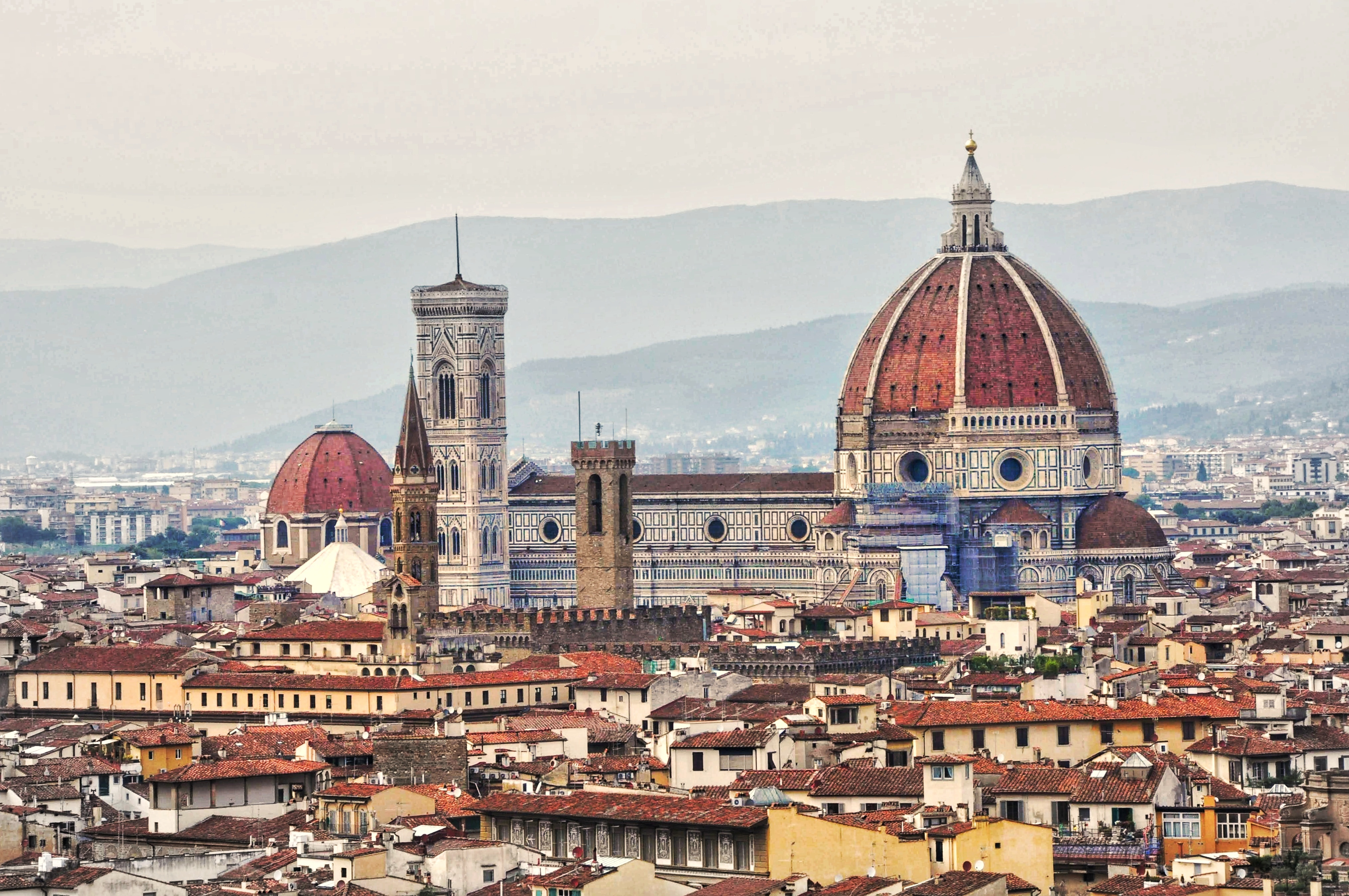
Florence is beautiful, captivating and filled with amazing stories that have significantly influenced and shaped the fate of the entire world. Walking through the streets of Florence, you can literally touch this history and feel the thrill of being so close to something extraordinary and unique in the world... but be careful! Florence is also kitschy, loud, crowded, damn expensive and insidious. This different, less pleasant face of Florence is the result of the modernity and popularity of the city, which is absolutely used to make quick money. The city streets are filled with tons of crap pretending to be souvenirs and traders (or rather scammers) wandering around looking for opportunities to make a quick buck.
However, if you know what awaits you and consciously ignore this slightly less pleasant appearance (it is possible and even quite easy) without paying much attention to it (although it is always worth watching out for petty thieves), Florence will charm you. The city will respond with a powerful charge of Renaissance taste, splendor, thoughts open to impossible things and will capture your memories forever!
I dedicated a separate guide to Florence – [click], because it cannot be described in one short note. Here I will include only some of the most important information that will allow you to quickly organize yourself and explore the city efficiently.
Firstly, parking the car. It is not that simple and obvious. Florence's entire downtown area is covered Limited Traffic Zone cars, marked as ZTL (Zona a Traffico Limitato). You can only enter it if you have the appropriate permissions. Tourists do not have such rights because the zone was created to limit the traffic they generate. You are not even allowed to enter the parking lot, which is located in the ZTL zone. Only vehicles authorized to stay in the ZTL zone can park there. Unauthorized entry into the ZTL area results in a high fine. There's no need to get caught. The area is monitored and the monitoring is regularly analyzed, so I do not recommend any combinations.
Accidental entry into the ZTL area is practically impossible, because each entrance is clearly marked with boards and traffic lights (I don't expect anyone to drive through a red light without reading the board).
There are periods during the day and at night when the ZTL zone does not apply and you can move around freely within it, but there is no point in providing this information here. When entry to the zone is allowed, the light changes from red to green and this closes the case. Anyway, below are the directions to several official parking lots available to tourists, located in a safe area right next to the border of the zone.
These parking lots are close to the most important attractions and it won't get any closer.
For better and faster orientation, I have prepared a simple map showing the location of parking lots and some of the most important and must-see attractions in the city.
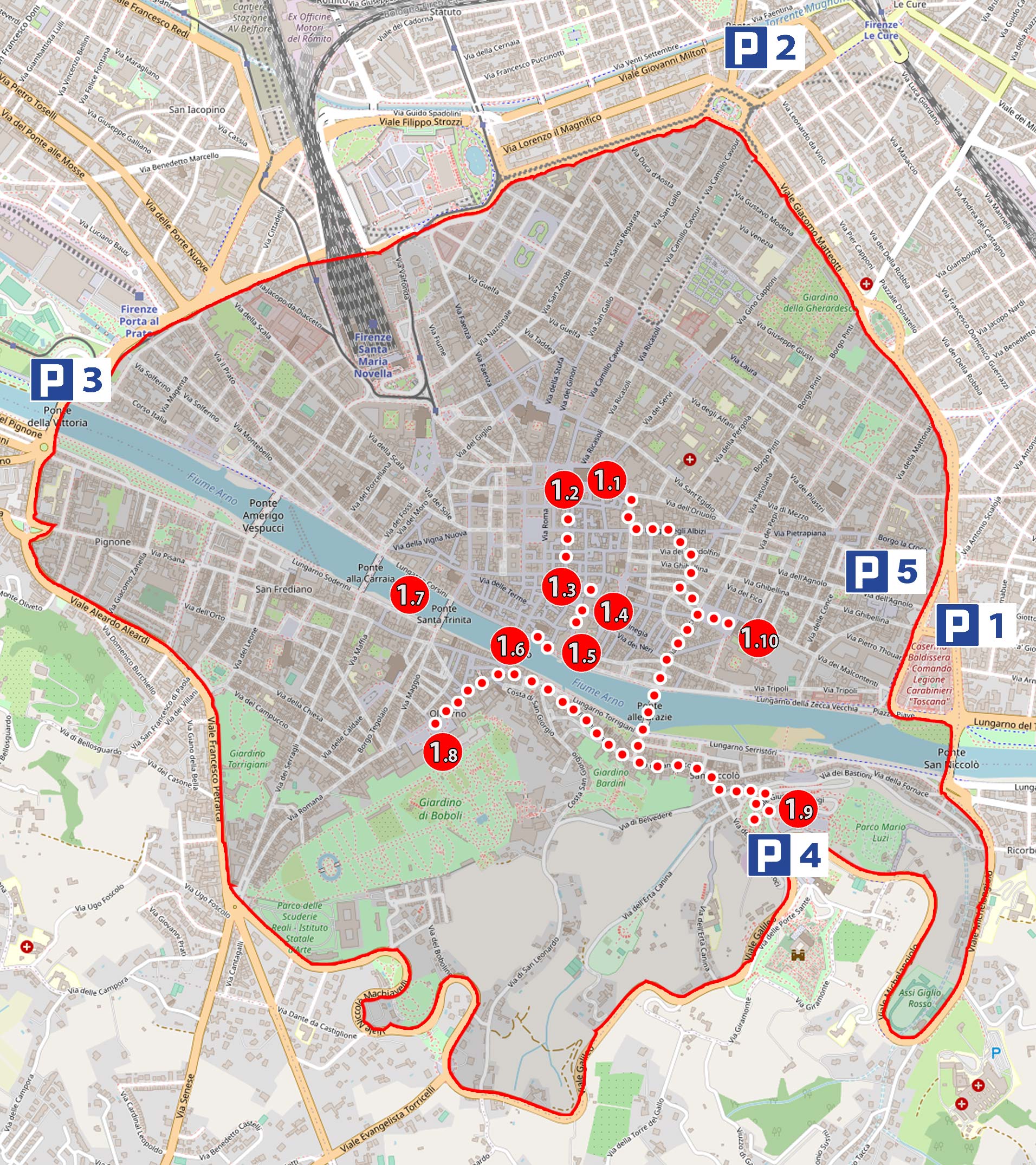
Map of the ZTL zone in Florence and the location of the main tourist attractions:
1.1 Cathedral of Santa Maria del Fiore (Cattedrale di Santa Maria del Fiore)
1.2 Giotto's Bell Tower (Campanile di Giotto)
1.3 Piazza della Signoria
1.4 Palazzo Vecchio
1.5 Uffizi Gallery (Galleria degli Uffizi)
1.6 Bridge of Vecchio (Ponte Vecchio)
1.7 Arno River
1.8 Palazzo Pitti
1.9 Michelangelo's Square with a panoramic view of Florence (Piazzale Michelangelo)
1.10 Church of Santa Croce
check out: accommodation Florence – [click]
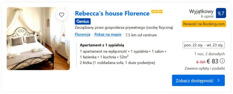
hotel: Rebecca's house Florence – [click]
Parking lots available to all tourists (outside the ZTL zone):
P1 – Underground parking lot: Parcheggio Beccaria, GPS coordinates:
43°46’10.7″N 11°16’15.3″E
43.769627, 11.270909 - click and route
P2 – Multi-story parking lot: Firenze Parcheggi – Parterre, GPS coordinates:
43°47’07.9″N 11°15’44.7″E
43.785527, 11.262414 - click and route
P3 – Outdoor parking: Parcheggio Vittorio Veneto, GPS coordinates:
43°46’31.7″N 11°14’09.8″E
43.775473, 11.236048 - click and route
P4 – parking lot at the Florence viewpoint: Parcheggio Viale Michelangiolo, GPS coordinates:
43°45’45.6″N 11°15’53.0″E
43.762671, 11.264726 - click and route
P5 – underground parking lot: Parcheggio Stazione Fortezza Fiera, GPS coordinates:
43°46’57.6″N 11°14’44.9″E
43.782656, 11.245808 - click and route
P6 – underground parking lot: Parcheggio Sant'Ambrogio Firenze, GPS coordinates:
43°46’12.9″N 11°16’06.7″E
43.770246, 11.268524 - click and route
the street leading to this parking lot does not belong to the ZTL, but everything beyond the access street is already a ZTL zone
2. Vinci

Vinci is a small town located somewhere among the Tuscan hills. This is where Leonardo was born. A man who, like few others, influenced the history of the world, science and technology. According to the once common rule, when the name of the town from which he came was added to a person's name (e.g. Zbyszko from Bogdaniec), Leonardo born here was called Leonardo da Vinci (i.e. Leonardo of Vinci).
If you are interested in Leonardo da Vinci, be sure to visit Vinci. There is a very interesting museum here, where you can see working machines and other inventions made strictly according to Leonardo's designs. You will also see copies of the painter's most famous frescoes and paintings. In my opinion, this is the best Leonardo da Vinci museum I have ever been to.
Less than three kilometers from the museum, you can visit the house where Leonardo lived since he was a child, still standing here. The exhibition here is very modest (interesting are holographic, three-dimensional projections of figures, including Leonardo himself, which tell the history of the place). For me, the mere fact of visiting Leonardo's house was enough.
check out: accommodation Vinci – [click]
Leonardo da Vinci Museum (ticket counter and museum entrance), GPS coordinates:
43°47’14.1″N 10°55’35.6″E
43.787241, 10.926567 - click and route
Parking lot at Leonardo da Vinci's house, GPS coordinates:
43°47’59.7″N 10°56’20.8″E
43.799923, 10.939100 - click and route
Leonardo da Vinci's house, GPS coordinates;
43°47’57.0″N 10°56’17.3″E
43.799177, 10.938125 - click and route
my hotel recommendation:
While traveling in Tuscany, we liked it hotel Monti – [click] in the town of San Baronto. It has everything we need, and the price has always been attractive.
3. Lucca
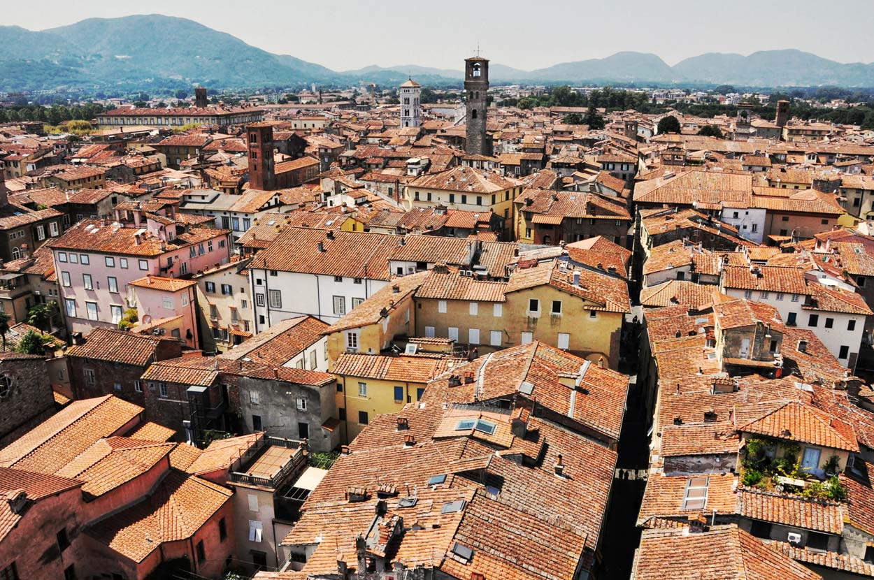
You must not miss Lucca. The city is really beautiful. It has largely preserved the architectural layout of the Roman city from the XNUMXst century BC and is entirely surrounded by a defensive wall. The compact nature of the city makes it very pleasant to visit. Narrow streets mean that even on hot and sunny days, you can always find some shade.
The key points are the oval Piazza dell Amfiteatro square, built on the site of a former Roman amphitheater (hence the shape and name), the beautiful Piazza San Michele square, where the characteristic church of San Michele stands, and the Cathedral of San Martino. It is also worth climbing to the top of the characteristic Guinigi Tower. You can easily recognize it because there are trees growing on its top :) Going to the top guarantees fantastic views of the city and the surrounding Tuscan lands.
Parking in a convenient place may be a minor problem. I definitely recommend using the paid, underground parking lot at Parcheggio Mazzini. The very fact that it is paid (although not expensive) makes it easier to get a place there. If there is no space in the indicated parking lot, you should look for a place near one of the entrance gates to the city. There are squares of various sizes next to them, with designated paid parking spaces. One of the largest is Parcheggio di Via del Pallone, which does not mean that you will 100% be able to find a place here.
check out: accommodation Lucca – [click]
Underground multi-story parking lot, Parcheggio Mazzini, GPS coordinates:
43°50’46.3″N 10°30’49.3″E
43.846205, 10.513698 - click and route
Parking on the street, Parcheggio di Via del Pallone, GPS coordinates:
43°50’31.1″N 10°29’47.0″E
43.841983, 10.496380 - click and route
4. Pisa
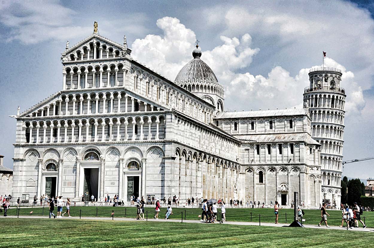
Everyone probably knows the symbol of Italy and the icon of Tuscany, the Leaning Tower of Pisa. I can't imagine exploring Tuscany without seeing the Leaning Tower with my own eyes. This is simply impossible.
The Leaning Tower of Pisa, located in the Square of Miracles, continues to enjoy great popularity and has become so popular that it has overshadowed other monuments in Pisa. So if you plan to come to Pisa, don't forget that in addition to the tower, there is a beautiful historical city center and the Arno riverfront surrounded by palaces.
From the Leaning Tower you will reach Piazza dei Cavalieri in 10 minutes (600 m), and the further walk to the bank of the Arno River near the Ponte di Mezzo will take another 6 minutes (450 m)
check out: accommodation Pisa – [click]
Huge parking lot near the Leaning Tower, GPS coordinates:
43°43’25.4″N 10°23’30.5″E
43.723726, 10.391800 - click and route
Leaning Tower of Pisa, GPS coordinates:
43°43’22.7″N 10°23’47.6″E
43.722978, 10.396557 - click and route
Piazza dei Cavalieri square in the center of Pisa, GPS coordinates:
43°43’09.8″N 10°24’00.5″E
43.719396, 10.400149 - click and route
The banks of the Arno River near the Ponte di Mezzo, GPS coordinates:
43°42’58.6″N 10°24’07.8″E
43.716266, 10.402164 - click and route
5. Calafuria
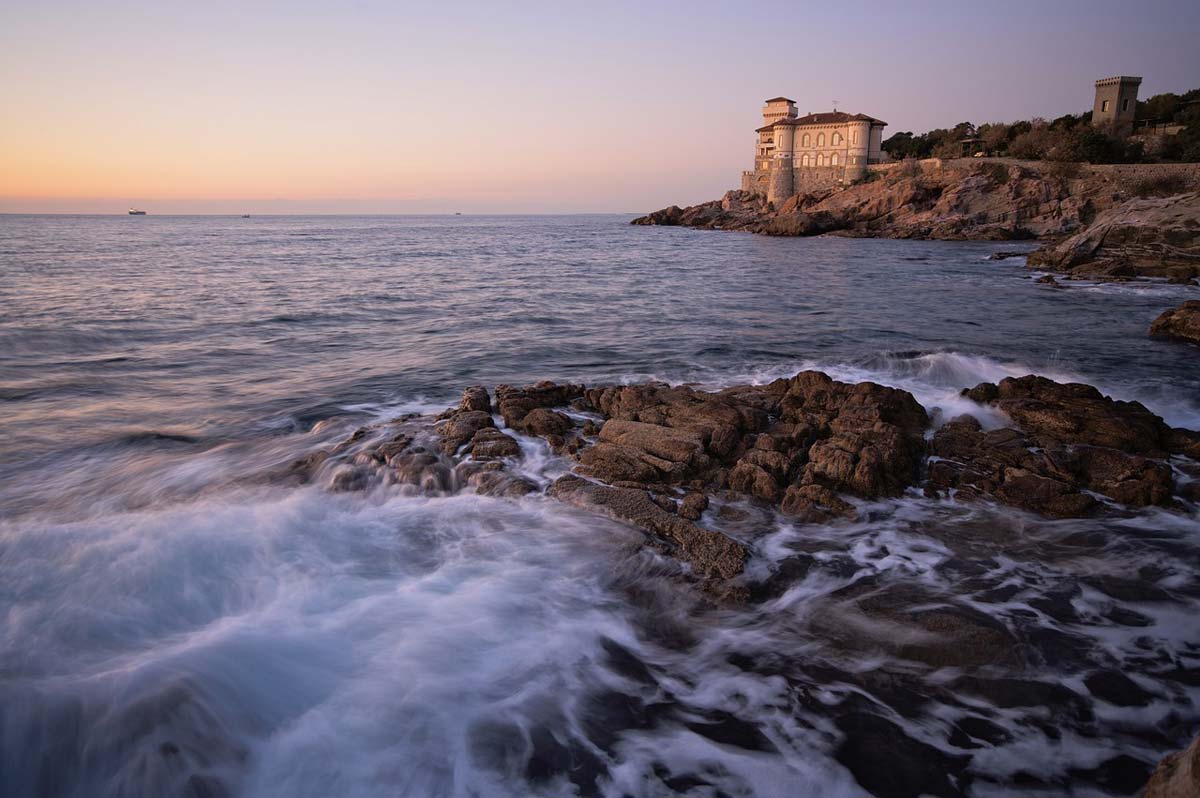
An interesting part of the Tuscan coast, especially for people interested in short walks, is located between the towns of Calafuria and Quercianella. On this part, the coast is high, rocky and rugged. Of course, it is not suitable for comfortable sunbathing, but it offers nice views and the opportunity to take a very short but pleasant walk. Be careful when walking, as there are no properly prepared paths here, only wildly trampled paths.
check out: accommodation Calafuria and Quercianella – [click]
One of the places in the central part of the coast where you can stop and walk on the rocks, GPS coordinates:
43°28’10.3″N 10°20’11.3″E
43.469535, 10.336479 - click and route
6. Volterra
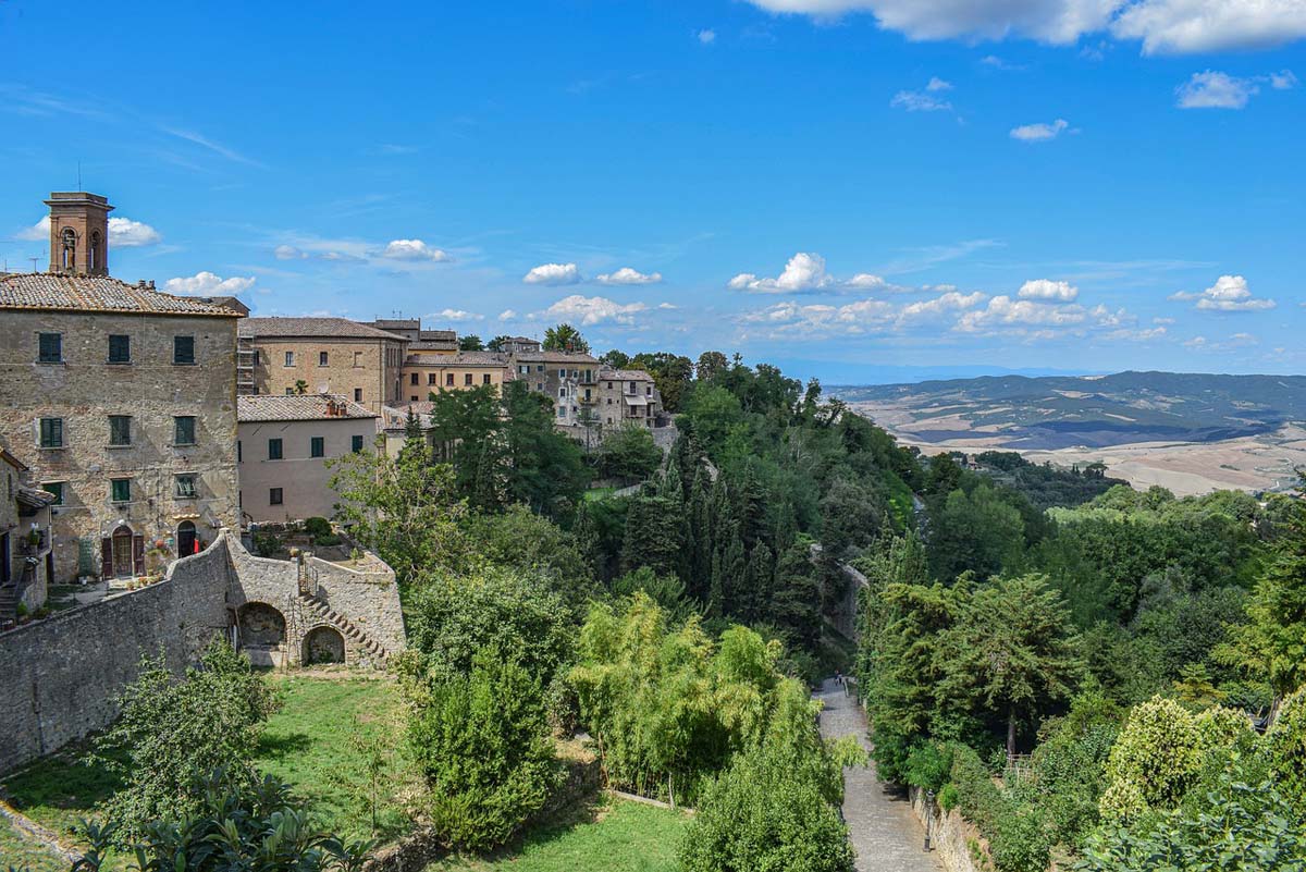
Volterra is a town that can easily be classified as small, medieval and beautiful :)
This is one of those towns where you can basically walk around without a guide, because for some reason you will find all the most interesting places on your own: the main square Piazza dei Priori and the town hall Palazzo dei Priori standing next to it, the ruins of the Roman theater, the castle, countless shops selling products. made of alabaster, a triumphal arch and a few other attractions. You will see all this by walking freely and looking here and there. There is probably no chance of losing your way.
check out: accommodation Volterra – [click]
Underground parking near the historic center of Volterra, GPS coordinates:
43°24’02.1″N 10°51’33.8″E
43.400578, 10.859388 - click and route
Depending on the direction from which you arrive in Volterra, on the way you may pass a parking lot conveniently located near the ruins of the Roman theater, marked Parcheggio per RESIDENTI. Although large and comfortable, it is intended only for residents (as the name suggests). Tourists are not allowed to park there.
7. San Gimignano
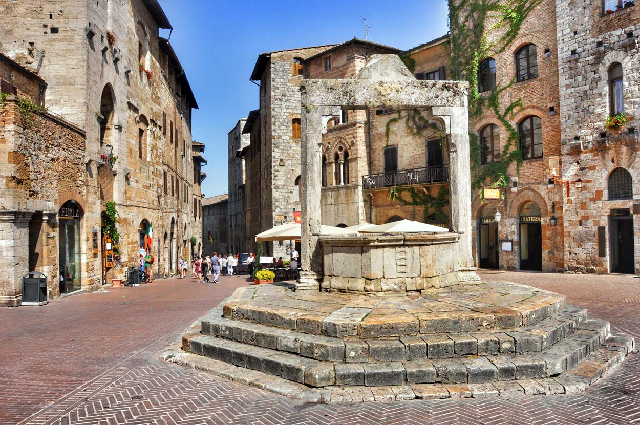
San Gimignano belongs to the same category of towns as Volterra (i.e.: small, medieval and beautiful), although many people will certainly say that it is even more beautiful. It is certainly equally easy and pleasant to visit.
By the way, I would like to add that San Gimignano is one of those places to which I can return endlessly. I just love this town and I love the commute to it. There are typical Tuscan, narrow roads leading here among rolling hills, and San Gimignano, thanks to its tall, medieval towers, is visible from afar. With each kilometer the towers seem to get higher and higher and we see more and more of them, as if the town consisted only of brick skyscrapers. This combination of the thoroughly modern shape of the city seen from a distance (as if it consisted of skyscrapers) with the actual medieval brick origin of the buildings makes a huge impression.
When visiting San Gimignano, it is worth considering additional time for standing in line. What for? For ice cream!
For some reason, right here, on the main square and on the main street of the city, there are ice cream parlors that constantly compete with each other. The competition is so intense that it has led to several ice cream parlors (probably three) winning the titles of world ice cream champions in different years! You will recognize them by the fact that there are queues in front of them. Each ice cream parlor has its fans who like their products and support them in the next championships.
I recommend! The best ice cream in the world, eaten on the steps of a medieval well on the main square (Piazza della Cisterna) in San Gimignano, tastes delicious!
Below are the directions to three parking lots. In my opinion, the most conveniently located parking lot is P2 (at the main gate to the city - Saint John's Gate - and at the beginning of the main walking street - Saint John Street). The next most convenient is P3, and I would choose P1 in third place. From the P1 parking lot, you need to walk approximately 500 m (7 minutes) to the city gate.
check out: accommodation San Gimignano – [click]
Montemaggio parking lot (P2) for tourists, GPS coordinates:
43°27’52.6″N 11°02’29.1″E
43.464613, 11.041418 - click and route
Bagnaia Superiore parking lot (P3) for tourists, GPS coordinates:
43°28’15.7″N 11°02’41.4″E
43.471020, 11.044830 - click and route
Giubileo parking lot (P1) for tourists, GPS coordinates:
43°27’40.2″N 11°02’21.7″E
43.461156, 11.039360 - click and route
8. Monteriggioni
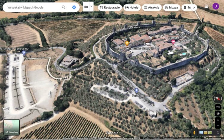
Monteriggioni is a small, almost pocket town. It is situated on the top of one of the gentle Tuscan hills and surrounded on all sides by greenery, vineyards and olive groves. It is so small that the wall surrounding it has a total length of just over 500 m. Every math enthusiast will immediately calculate the diameter of the city (I suggest: diameter d = Circumference / Pi). For those who don't like to count, I'll tell you straight away: the diameter is very small :)
Visiting Monteriggioni will take you little time and a stop here is worth treating mainly as a curiosity and an opportunity to stretch your legs for a few minutes.
check out: accommodation Monteriggioni – [click]
Parking for tourists in Monteriggioni, GPS coordinates:
43°23’17.2″N 11°13’29.7″E
43.388101, 11.224928 - click and route
9. Sienna
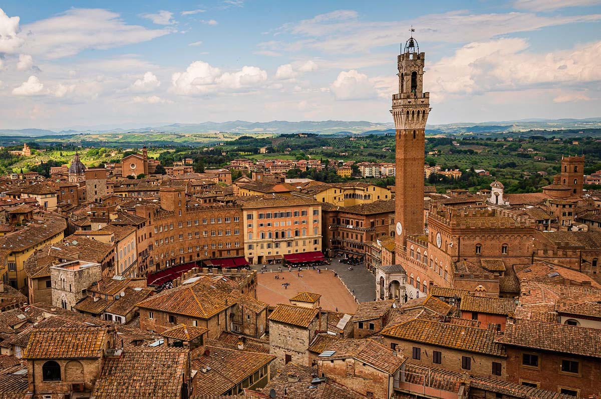
To put it briefly: Siena stole my heart. I spent a lot more time here than I originally expected. And it's not that I planned the tour wrong. On the contrary. Everything was well thought out and I didn't have to rush anywhere. I saw everything I wanted, and then... then I just felt the need to stay here longer. So I did. I stayed longer, but I was still sad to leave Siena. I promised myself that I would come back here as many times as possible. So I may be biased in my assessment of Siena, but on the other hand it is difficult to overestimate this city.
Siena, like other cities, is located on a quite steep hill and most of it is connected to this hill. It extends widely beyond the relatively gentle peak of the hill, which means that a large part of the city climbs sharply uphill or falls down at breakneck speed. So we have a lot of narrow and very steep streets and countless stairs. The city flattens out a bit towards the most important city squares, but nowhere is it completely flat. I think I will include more about Siena in a separate description and guide to this city.
There are two pieces of information that are most important in this entry. The first is the parking lot, and the second is how to get to the center. Siena's shape and tight buildings make it virtually impossible to drive around the city. It is very difficult and very limited even for residents. Tourists are banned from entering the city. Therefore, you should leave your car in a parking lot outside the center of Siena and walk to the center.
What may be a little scary is the fact that from the parking lot to the historic center, i.e. Piazza del Campo and Piazza del Duomo, it's a really steep uphill climb! Don't worry though! The city authorities thought about it. On the way from the parking lot, after passing the city gate, look for signs leading to the escalators. Yes! You can take several sections of escalators almost from the city gate to the very top of the hill! Beautiful, right?
Unless you feel like doing some physical exercise? You can climb through the streets and regular stairs. Siena is waiting and inviting you!
check out: accommodation Siena – [click]
Entrance to the parking lot in front of the city gate in Siena, GPS coordinates:
43°19’02.1″N 11°19’26.7″E
43.317241, 11.324073 - click and route
Direction to the escalator to the center of Siena, GPS coordinates:
43°19’06.0″N 11°19’37.0″E
43.318334, 11.326939 - click and route
Square in front of Siena Cathedral (Piazza del Duomo), GPS coordinates;
43°19’02.4″N 11°19’43.0″E
43.317323, 11.328596 - click and route
Square in front of Siena's town hall (Piazza del Campo), GPS coordinates:
43°19’06.3″N 11°19’54.2″E
43.318424, 11.331720 - click and route
10. Arezzo
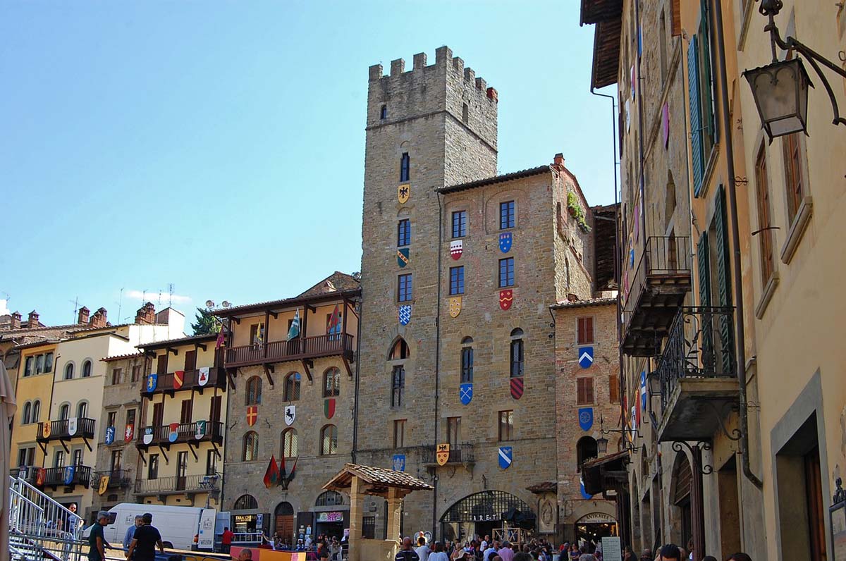
Arezzo is a bit off the beaten track in our itinerary. It is a city whose size definitely exceeds the small towns we have become accustomed to in Tuscany. Its biggest attractions (e.g. Santa Maria della Pieve, Palazzo Pretorio, Cathedral of St. Peter and St. Donatus) are located close to the main square, Piazza Grande, and people come to the city mainly for these monuments.
Generally, Arezzo is located off the main tourist route in Tuscany and if you are looking for a place where the tourist traffic is much lower, this may be an interesting proposition (lower hotel and gastronomy prices).
check out: Arezzo accommodation – [click]
Large parking lot near Piazza Grande in Arezzo, GPS coordinates:
43°28’10.2″N 11°53’03.7″E
43.469500, 11.884351 - click and route
The main square (Piazza Grande) in Arezzo, GPS coordinates:
43°27’53.2″N 11°53’03.4″E
43.464788, 11.884288 - click and route
11. Val d'Orcia and Crete Senesi
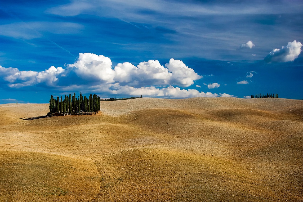
Val d'Orcia and Crete Senesi are not specific points. These two names cover two separate areas. Each of these areas covers a large part of Tuscany. My marking these two areas on the map (Val d'Orcia and Crete Senesi) under one number can be considered a bit of an abuse, and in fact it is. However, I did it on purpose.
In practice, they cannot be visited separately because they are partially intertwined. The communes that are located on the border between the areas practically belong to both of them. Moreover, even though they cover a significant area of Tuscany, when traveling by car we have to cover distances that pose a great challenge. Without excessive effort, they can be overcome in one day (or by bike or on foot).
However, the most important argument is that many of the photos that attract tourists to these areas, even though they are taken in Crete Senesi, for example, are described as having been taken in Val d'Orcia (the opposite is rarely the case). Such inaccuracy may be misleading, but fortunately it will not prevent us in any way. You just need to be prepared to wander around both areas in search of the best viewpoints.
As always, the best planning tool will be a map. I couldn't find a map on the Internet that would present the matter in a clear enough way, so I had to make such a map myself, based on a map base from openstreetmap.org. Of course, it does not reflect the precise course of administrative borders, but it very well reflects the scope and location of the areas we are interested in.
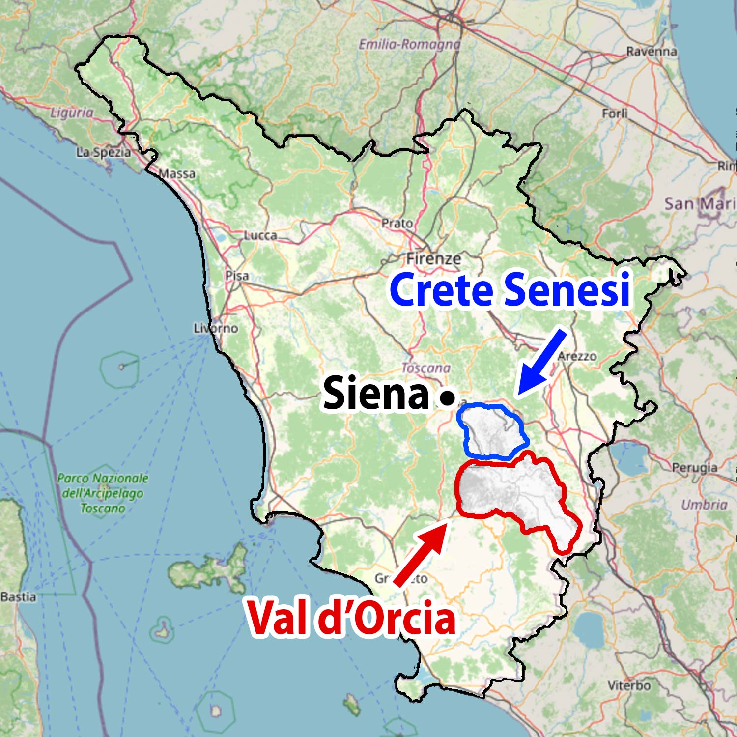
The map above shows the area of Tuscany that you already know. I marked the location of Siena on it. South of Siena begins the Crete Senesi area surrounded by the blue line, and going even further south we will reach the Orcia river valley, called Val d'Orcia in Italian.
For those who will plan their own outdoor trips in search of the most beautiful scenery in Tuscany, I have prepared a separate entry with descriptions and detailed GPS coordinates of several of the most famous viewpoints: Val d'Orcia (map) – the most beautiful viewpoints in Tuscany. It is so extensive and there is so much information in it that I decided to separate it from this entry and post it in a separate text.
12. Montepulciano
Montepulciano is a postcard place. Situated on a hill, with the typical, tight, medieval character of pleasant streets. The perfectly preserved nature of the buildings (in Montepulciano it has long been strictly forbidden to modify anything yourself) means that some people treat the town as exemplary in every respect.
Visiting Montepulciano is not overly complicated because the town is quite small. It is worth taking a typical walk: the main and side streets, the main square and the cathedral. Basically, you will get everywhere by following your intuition. It is worth noting the viewpoints over the Val d'Orcia valley (GPS coordinates below), because due to its relatively high location, Montepulciano offers one of the most beautiful and very extensive panoramas of this valley.
The city has prepared 10 parking lots for tourists (all paid), but most of them are really small parking lots or just a row of spaces on the street. On most of them, there may be a problem with free seats. So I suggest starting with the parking lot P1, located near the entrance gate to the city. If you don't make it there, you can try at the parking lot located a few hundred steps away P5. It is the largest of all and the chances of parking here are also the highest.
check out: accommodation Montepulciano – [click]
Parking lot P1 in Montepulciano, GPS coordinates:
43°05’52.3″N 11°47’06.0″E
43.097864, 11.784992 - click and route
Parking lot P5 in Montepulciano, GPS coordinates:
43°05’45.3″N 11°47’14.4″E
43.095907, 11.787322 - click and route
Viewpoint over the Val d'Orcia valley, GPS coordinates:
43°05’39.9″N 11°46’51.0″E
43.094427, 11.780833 - click and route
13. Pienza
Pienza is located in the Val d'Orcia valley, which, as you can easily guess, guarantees beautiful views from the town to the valley. Just climb the walls surrounding the city and take a walk around them. Everyone will find the most beautiful viewpoint here. That's for sure.
The historic center of Pienza is truly pocket-sized, so don't expect a long walk. Instead, focus on a quiet walk and spend some time enjoying the views of the picturesque Val d'Orcia valley. Sit down, drink coffee, eat something, take your time. One main street, several short side streets, main square, cathedral, city walls. Tight and nice 🙂
check out: accommodation Pienza – [click]
Parking near the historic center of Pienza, GPS coordinates:
43°04’41.6″N 11°40’49.5″E
43.078207, 11.680414 - click and route
14. Bagni San Filippo
In Tuscany you can find many thermal springs, creating natural pools, hot streams and watercourses. The mineral-rich water has created picturesque, colorful mineral structures in many places, which attract not only bathing enthusiasts, but also lovers of natural wonders.
Bagni San Filippo has become a popular swimming spot over time (which has generally not been a good thing for this place), but it still attracts many people with its extremely interesting mineral dripstone structures.
The area is not large, so it quickly fills with people. It is best to come here outside the summer season. However, if you cannot choose such a date and you will be here in the summer, I suggest arriving outside the weekend and possibly early in the morning.
check out: accommodation Bagni San Filippo – [click]
Bagni San Filippo, picturesque dripstone mineral structures, GPS coordinates:
42°55’44.7″N 11°42’11.3″E
42.929085, 11.703145 - click and route
Parking lane on the road to Bagni San Filippo, GPS coordinates:
42°55’43.2″N 11°42’09.7″E
42.928671, 11.7027025 - click and route
The parking lane ends at approximately the location indicated by the GPS coordinates I provided. So try to park before you get to this point.
15. Pitigliano
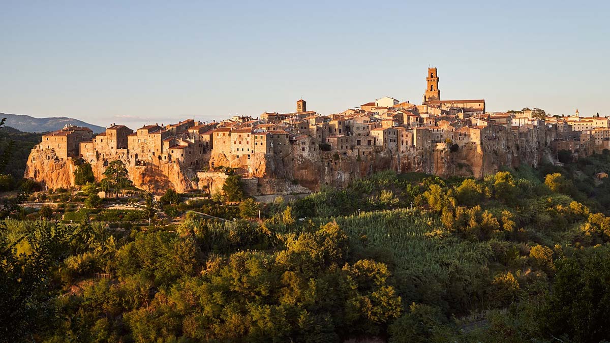
Thanks to its location, Pitigliano quickly became a widely recognizable place. The city was built from a rock identical to the one on which it stands. The buildings therefore seem to grow straight out of the bedrock as if they were still part of the rugged hill on which they are located. The impression is amazing, especially when the front of the mountain and the facades of the buildings connected to it are bathed in the warm light of the gentle morning sun. So if you want to see Pitigliano in its most beautiful version, you have to arrive at the viewpoint at sunrise.
It's worth starting your visit to the old part of Pitigliano by… finding a parking space. The old part of the city does not offer parking at all and you have to look for a place somewhere else. I suggest starting your visit by visiting a viewing point overlooking the hill and the old town. There is a parking lane along the access road to the viewing point. If you're lucky, you'll find a place here. If not, continue slowly towards the next parking space I mentioned (in Piazza del Mercato). The parking lane will run along your route, so use the first available space. If there is nothing free on the way, your last hope is in Piazza del Mercato, where you should find something.
Pitigliano is visited intuitively. Two parallel streets run along the entire length of the hill (Via Roma and Via Zuccarelli). You follow one of them to the end and then go back with the other one. Along the way, the streets first split up and then merge together at the end.
The further into the town you go, the tighter and more interesting it becomes. It's worth looking everywhere. A picturesque alley may be lurking around every corner. Here is the entire sightseeing plan :)
check out: accommodation Pitigliano – [click]
Viewpoint of the old part of Pitigliano and parking spaces along the street, GPS coordinates:
42°38’00.1″N 11°40’15.0″E
42.633360, 11.670823 - click and route
A little more parking space in Piazza del Mercato, GPS coordinates:
42°38’01.0″N 11°40’26.6″E
42.633602, 11.674041 - click and route
16. Terme di Saturnia
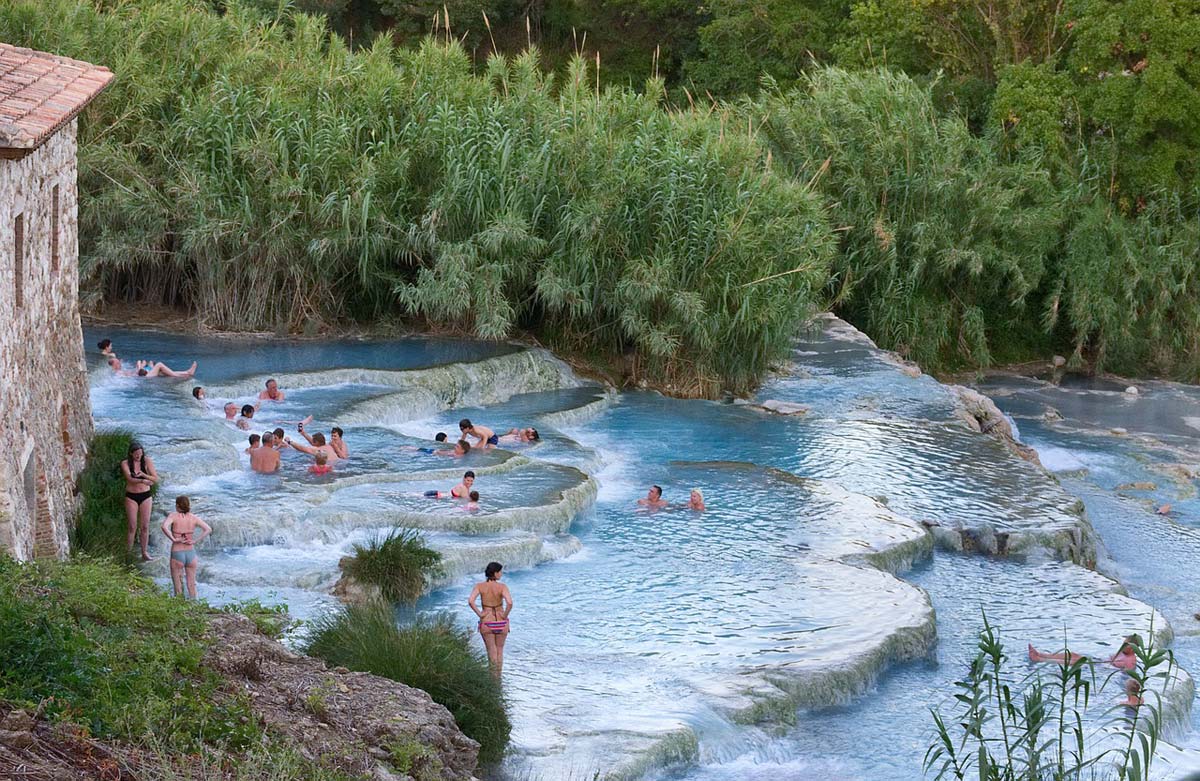
In the case of Terme di Saturnia, you may be interested in two locations. The first of them is Cascate del Mulino di Saturnia, i.e. exceptionally photogenic, cascading limestone pools in the open air, from which warm thermal water flows. The second is the Terme di Saturnia hotel with thermal springs and additional swimming pool infrastructure. It was built directly on these sources and offers a wide range of treatments, baths and SPA services.
If you are looking for relaxation and rest in good (but not necessarily cheap) conditions, this may be a good option for a short break in your journey.
Below are the locations of both places.
check out: accommodation Saturnia – [click]
Terme di Saturnia (hotel with SPA at a thermal spring), GPS coordinates:
42°39’25.6″N 11°30’57.9″E
42.657110, 11.516078 - click and route
Cascate del Mulino di Saturnia (natural thermal pools), GPS coordinates:
42°38’53.4″N 11°30’45.5″E
42.648152, 11.512651 - click and route
Parking near Cascate del Mulino di Saturnia, GPS coordinates:
42°39’05.5″N 11°30’40.9″E
42.651517, 11.511354 - click and route
A viewpoint overlooking Cascatelle del Mulino, located by the road, GPS coordinates:
42°38’44.5″N 11°30’45.2″E
42.645682, 11.512561 - click and route
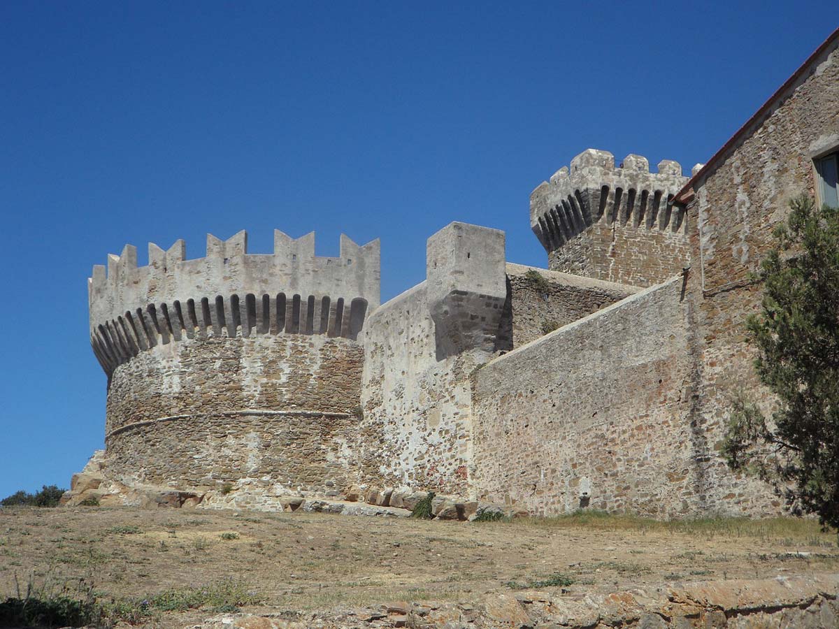
17. Argentario Peninsula
Most guides to Tuscany do not offer suggestions for visiting the Argentario peninsula. Honestly, I wonder why? When it comes to the coastal part of Tuscany, the Argentario peninsula is definitely an attraction worth especially recommending. Perfect, crystal clear sea, fantastic beaches, cypress valleys, green hills, picturesque sea bays, excellent food (including amazing seafood). It's all here! So why would we be missing?
What is not? There are no typical Tuscan vineyards and olive groves. But after many days of staying among endless vineyards and olive groves, won't such a change be pleasant? Of course it will! Pleasant and refreshing.
The Argentario Peninsula used to be an island, but it was artificially connected to the mainland, which significantly improved access to it. You can get here easily (via an artificial causeway) by car.
An attraction that has always delighted and still delights tourists on the Argentario Peninsula is the opportunity to sail independently in a small motor boat along the shore of the peninsula, from bay to bay. This does not require any special permissions or skills. The boats are safe (usually for 2-4 people), and the engines installed in them have limited power (for safety). You rent a boat for the whole day and during that time you sail among picturesque bays, getting to know the island from the water in your own way.
The adventure is great and when time runs out, it's a pity to go back.
Two main towns on the island are best for accommodation and a base:
– smaller and more intimate: Porto Ercole - check accommodation prices [click]
– a bit larger and a bit more noisy: Porto Santo Stefano - check accommodation prices [click]
Parking near the marina in Porto Ercole, GPS coordinates:
42°24’10.2″N 11°12’15.7″E
42.402819, 11.204364 - click and route
Parking near the marina in Porto Santo Stefano, GPS coordinates:
42°26’01.6″N 11°07’25.7″E
42.433781, 11.123793 - click and route
18. Populonia and the Gulf of Baratti
This point of the program is a classic combination of pleasure and usefulness. We have a beautiful beach here in the Baratti Bay, which begs to laze on for a while, but right next to it (only 1,5 km in a straight line), it looks at us from the top of a coastal hill. Populonia: the oldest Italian port! In ancient times, it was one of the largest and most important cities on the Mediterranean Sea and a copper smelting center (the city had the status of an episcopal capital already in the XNUMXth century). It is estimated that in the Iron Age Populonia could have numbered even 40 inhabitants (Rome reached this size about 300 years later than Populonia).
After almost 1000 years of operation, Populonia lost its importance and was abandoned. In 2009, officially... 17 people lived here. Today, Populonia is mainly a tourist destination. I recommend visiting Populonia as a break from the beach!
check out: accommodation Baratti Bay – [click]
Parking lot in front of the city gate in Populonia, GPS coordinates:
42°59’20.9″N 10°29’25.1″E
42.989147, 10.490296 - click and route
Parking lot no. 1 near the beach in the Gulf of Baratti, GPS coordinates:
42°59’46.0″N 10°31’06.3″E
42.996101, 10.518411 - click and route
Parking lot no. 2 near the beach in the Gulf of Baratti, GPS coordinates:
42°59’37.3″N 10°30’51.8″E
42.993694, 10.514380 - click and route
Parking lot no. 3 near the beach in the Gulf of Baratti, GPS coordinates:
42°59’27.9″N 10°30’40.8″E
42.991072, 10.511323 - click and route
19. Marina di Castagneto Carducci
There aren't many beach-related suggestions in my guide. However, the ones that are available were selected based on a strong selection process. I didn't want to suggest many similar places. I decided to choose and propose only the most interesting ones.
Marina of Castagneto Carducci has many advantages. First of all, it's not crowded yet and probably won't be for a long time. The beach here is long and wide, and the village next to it is small. The village, in turn, is divided into two parts: the tourist part with low hotel buildings and the second part, a little more distant from the beach and inhabited by permanent residents. This division makes the tourist and beach part live its own holiday life, and that's cool.
In addition, it is enough to add that the beach and sea water are kept in a high class of cleanliness and ... we have a recipe for a successful holiday in a quiet - for Italian conditions - place!
check out: accommodation Marina di Castagneto Carducci – [click]
Parking by the beach in Marina di Castagneto Carducci, GPS coordinates:
43°10’51.2″N 10°32’18.8″E
43.180898, 10.538546 - click and route
20. Marina di Cecina
This time something for lovers of slightly larger tourist resorts. Marina di Cecina it has everything that such a resort should have. The right size to create an atmosphere of evening and nightlife and to guarantee a wide catering and hotel offer.
check out: accommodation prices in Marina di Cecina – [click]
There are various types of restaurants, bars, ice cream parlors, and shops with everything you need while on vacation. There are paid beaches with umbrellas and free beaches, playgrounds for children, carousels, a lively promenade, open-air concerts, street shows and a nice marina... to choose from.
Whoever likes it will be pleased!
Small parking lot near the beach in Marina di Cecina, GPS coordinates:
43°18’03.0″N 10°29’29.3″E
43.300824, 10.491480 - click and route
Important to me!
Give the article a good rating (5 stars welcome 😀)!It's free, a for me it is very important! The blog lives on visits and thus has a chance to develop. Please do it and ... thank you in advance!
If you like my guides, you will certainly find the one I created useful guide catalog - [click]. There you will find ready-made ideas for your next trips, descriptions of other tourist destinations and an alphabetical list of guides divided into countries, cities, islands and geographical regions.
I also post link to Facebook profile - [click]. Come in and press "Follow"then you will not miss new, inspiring posts.
Unless you prefer Instagram. I'm not a social media demon, but you can always count on something nice to look at on my instagram profile - [click]. The profile will gladly accept any follower who likes it.
I make the content I create available free of charge with copyright, and the blog survives from advertising and affiliate cooperation. So, automatic ads will be displayed in the content of the articles, and some links are affiliate links. This has no effect on the final price of the service or product, but I may earn a commission for displaying ads or following certain links. I only recommend services and products that I find good and helpful. Since the beginning of the blog's existence, I have not published any sponsored article.
Some of the readers who found the information here very helpful, sometimes ask me how you can support the blog? I do not run fundraisers or support programs (type: patronite, zrzutka or "buy coffee"). The best way is to use links. It costs you nothing, and support for the blog is self-generating.
Pozdrawiam

Great guide. Seriously. I am planning to go to Tuscany by car in 2024 and I will torture your guide cruelly. Thank you very much!
You can ride and ride.