Tenerife – map, attractions, sightseeing plan, trips, the most beautiful places
Mystery Island
If you like to discover new places, Tenerife will satisfy your appetite. The island offers plenty of opportunities and activities, and is extremely diverse and interesting. It is often called "Earth in a nutshell" because at the same time in different places there can be extremely different atmospheric conditions, resembling the four seasons. The scenery can vary from extremely dry and desert to humid, even wet with dense vegetation. The island is small enough that you can visit all the zones in one day, although I don't recommend it. It is worth spending more than just a moment on each of these places.
Tenerife owes its diversity to the huge Teide volcano. It is the central point of the island, and when driving around Tenerife you basically drive around it. The powerful cone towers over the entire island, proudly looking at its work, because Tenerife was created and exists mainly thanks to its activity. It is also the main source and cause of climatic diversity on the island. One of the phenomena can be observed without much effort. When traveling around Tenerife, you will surely notice that the 3715-meter-high volcano creates a huge barrier to the clouds. The clouds hanging much lower are unable to get from the northern to the southern side of the island. So they gather and cumulate on the northern side of the volcano and, leaning against its cone, they often form a thick and extensive layer. This way, while it is cloudy, gloomy and even rainy in the north, south of the volcano the sky is clear, blue and almost constantly sunny. When there is moisture in the north, there may be a long drought several dozen kilometers away on the other side of the volcano. This has significant tourism consequences.
Two halves of Tenerife
Attractions in Tenerife can be divided into two main groups and this is not the most commonly used division into: nice and slightly uglier ones. The dividing line runs somewhere completely different. A division should be made here: very popular attractions and less frequently visited ones. At first glance, it may seem that it is basically the same thing, because nice attractions are always visited more willingly, and the slightly uglier ones are less popular, but this is not the case in Tenerife. Here, the popularity of attractions is closely related to the weather and the climate dividing line generated by the volcano and the clouds associated with it. The most frequently and most frequently visited are those in the south, west (where the sun usually shines) and the center, where the Teide volcano is located. The northern side of the island, especially the north-eastern one, is incomparably less popular.
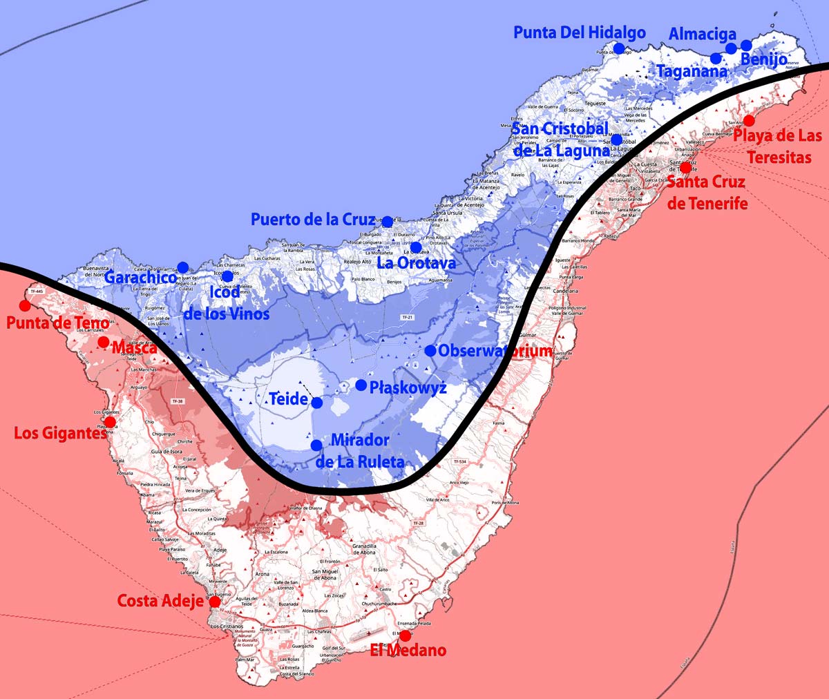
– the northern part – cool and humid
– southern part – warm and dry
Is it right? Are there no interesting attractions in the north and east? Of course they are! Nay! These are attractions that are often remembered with greater emotion and delight than those in the south.
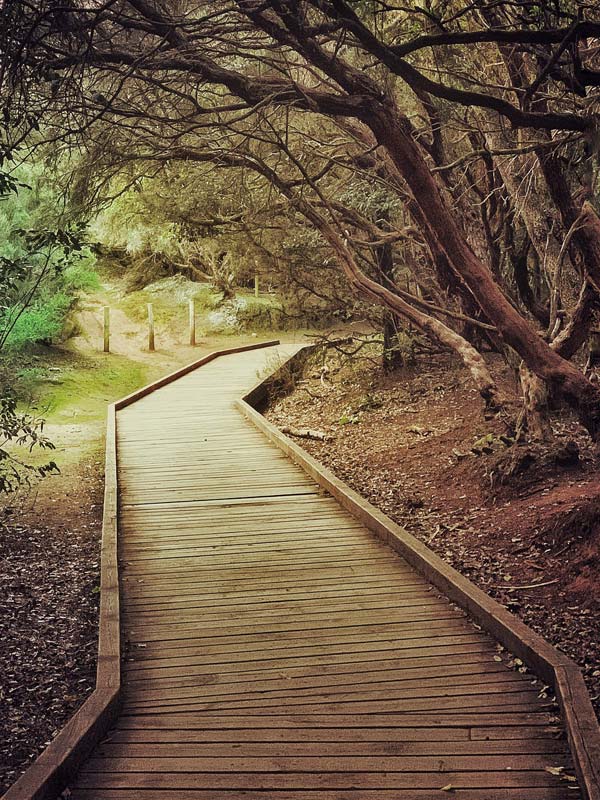
However, most tourists go to Tenerife in search of sun, so they give up visiting the eastern and northern parts of the island. Most hotels and tourist resorts are located on the southern coast of Tenerife. This creates an additional difficulty, because to see the attractions in the east you have to drive across the entire island. Attractions in the north and east of the island are clearly less popular (mainly Parque Rural de Anaga, or in precise translation Anaga Rural Park).
This may worry you, but not me! You just need to look at it a little differently. For someone looking for unique places where you can enjoy peace and quiet while admiring extraordinary scenery, the north-eastern part of Tenerife is a real paradise. Sometimes you can even feel like an explorer here. This is an underestimated value that the island offers, giving us a geographical wonderland devoid of crowds, as wild as it is possible today.
In this guide, in addition to the most famous and most visited attractions of Tenerife, you will also find a lot of places that most do not visit or recommend. I have no doubt that visiting them will give you a lot of pleasure and satisfaction. It's possible that you, too, will fall in love with this part of the island.
Tenerife – basic information
Politically, Tenerife is part of Spain and one of the islands in the Atlantic Ocean belonging to the Canary Islands archipelago. The official language is Spanish and the currency is Euro.
Roads drive on the right, and prices of goods and services are moderate, typical of most European countries.
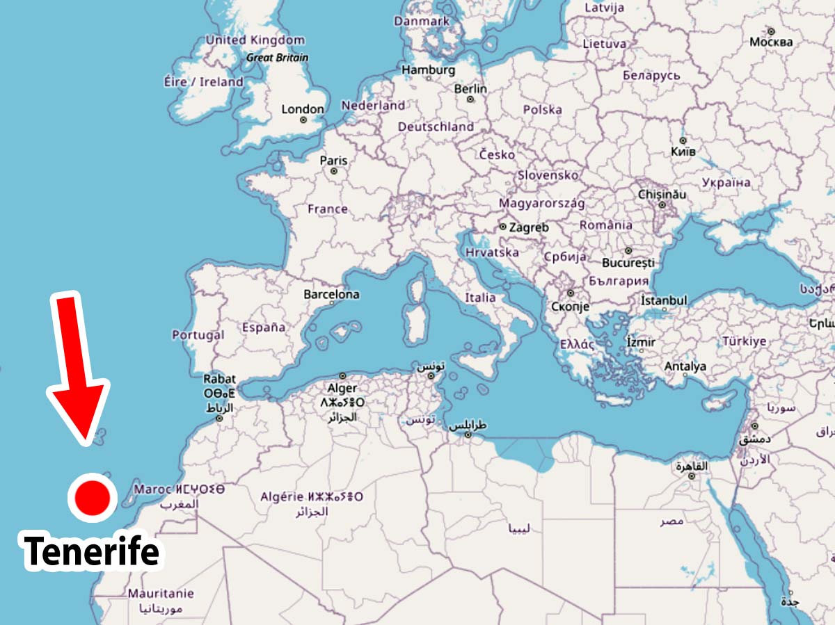
Where is Tenerife?
The Canary Islands archipelago is located west to the coast of north-west Africa and (which often surprises tourists), every year the wind blowing from Africa brings large masses of sand straight from the Sahara to Tenerife, grain by grain. Analyzing the location of Tenerife, it is much easier to see it all on the map.
The Canary Islands archipelago consists of 7 large and 6 small islands.
Large islands:
– Tenerife (area: 2034,38 km²)
– Fuerteventura (1659,0 km²)
– Gran Canaria (1560,10 km²)
– Lanzarote (845,94 km²)
– La Palma (708,32 km²)
– La Gomera (369,76 km²)
– El Hierro (268,71 km²)
Small islands:
– Graciosa (29,05 km²)
– Alegranza (10,3 km²)
– Lobos (4,58 km²)
– Montana Clara (2,7 km²)
– Roque del Este (6,45 ha)
– Roque del Oeste (1,589 ha)
Among the small islands, only one (Graciosa) has been considered inhabited since 2018.
Island dimensions and communication
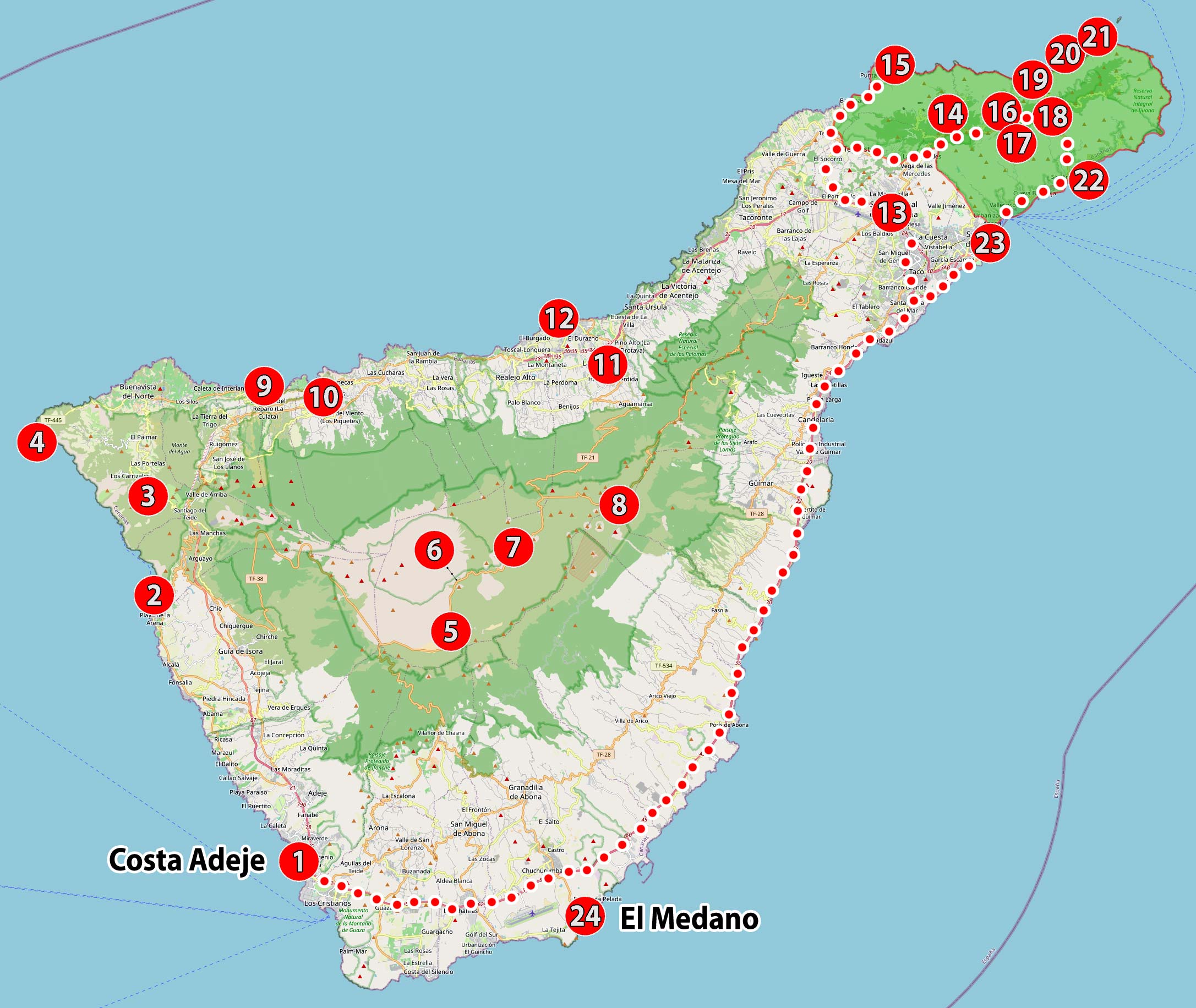
Tenerife is not a small island, but it is not big either. It can be said that it has a great size that makes it a pleasure to travel around. On the map below, I have given its dimensions in a straight line, and I have marked the main road that leads around the island with red dots. The entire loop is 180 km long and, according to Google navigation, the entire loop can be completed in 2 hours 30 minutes.
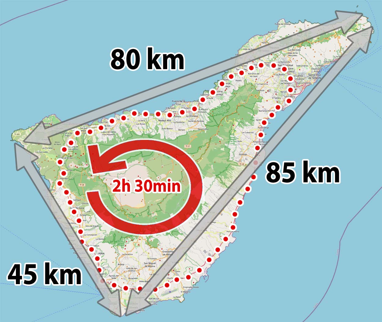
The largest part of the loop is a comfortable two-lane road (142 km in total), part of it is an easy and not too winding two-way road (23 km in total) and only in a short fragment approximately between Santiago del Teide and El Tanque it takes on the character of a winding mountain road (in total approximately 15 km).
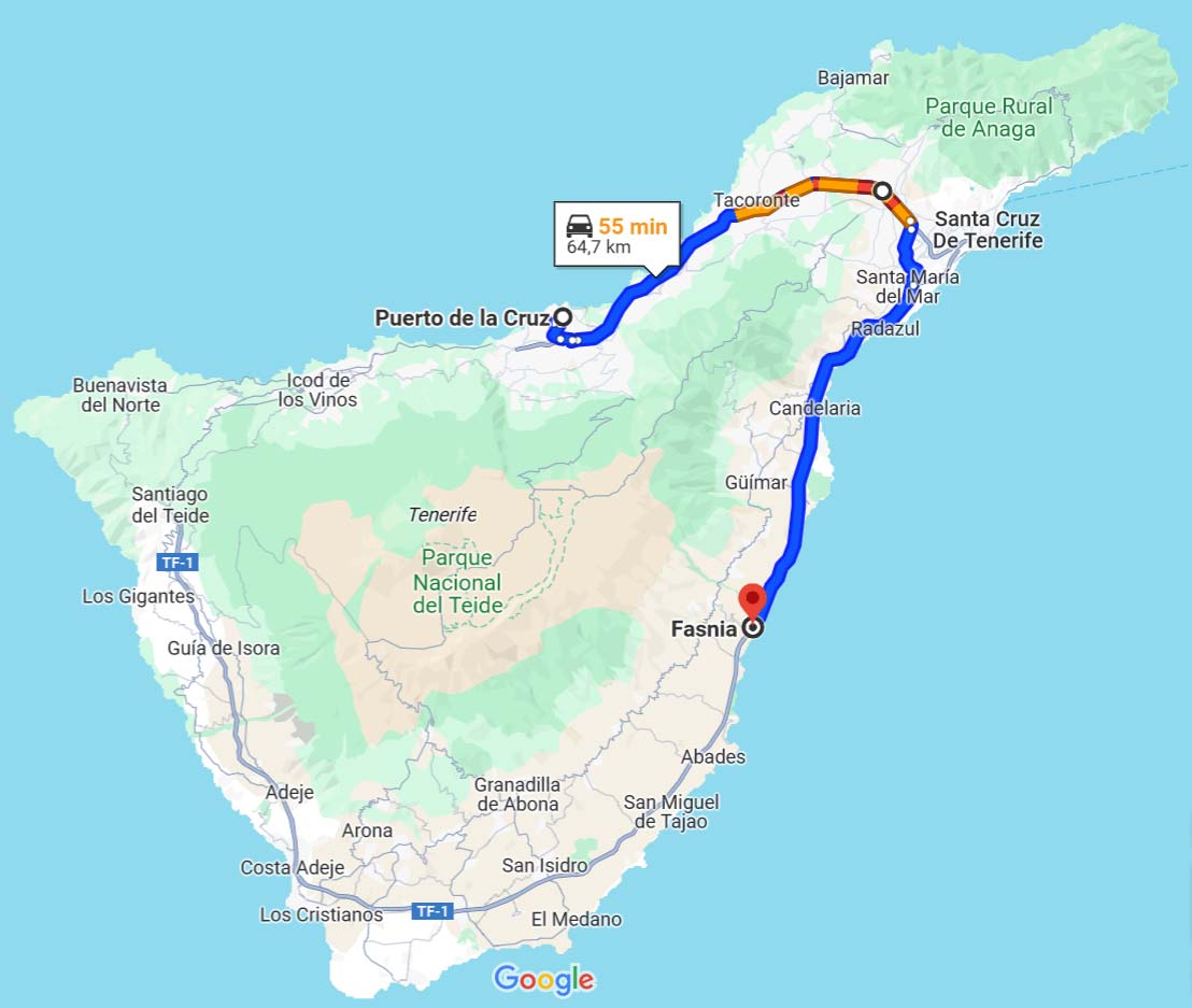
If you're wondering if it's possible to drive through the middle of the island to the opposite side of the island, my answer is: it's possible! However, please remember that there is a large volcano in the middle of the island and only very winding mountain roads run here. Driving them will definitely take you more time than driving on the main road around the island.
Example:
It will take you about 25 hours to drive through a narrow piece of land from Fasania to Puerto de la Cruz (these two places are 2 km apart in a straight line) going through the center of the island.
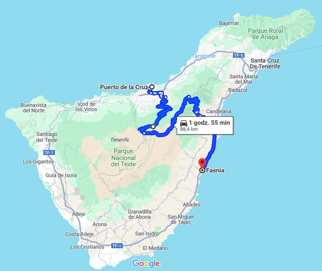
The same journey around on the main road will only take 55 minutes.
How to visit Tenerife?
There are no railway lines on the island, so this method of traveling is completely out of the question. There is a decently developed bus network here and if it makes sense, I include line numbers in the descriptions of some attractions. However, if you decide on this form of transport, you must take into account the fact that in this guide you will also find attractions that cannot be reached by bus. They just don't get everywhere. Additionally, take into account the fact that traveling by bus will take you much longer, so you will have to give up many attractions due to lack of time.
If you want to make the most of your stay and minimize the amount of time you waste on technical travel from place to place, renting a car seems to be the only reasonable option. Most tourists quickly come to this conclusion, so no one should be surprised by the fact that the car rental network on the island is very well developed, and therefore the prices are very affordable.
Renting a car may seem difficult, but in practice it doesn't have to be. I have prepared a solid and clear guide on this topic, in which you will find a set of information that will allow you to easily avoid the most common mistakes and rent a car in Tenerife cheaply and safely: Tenerife – car rental guide – [click]
Hotels and accommodation
Accommodation in Tenerife is large and diverse. The price range is also wide, so everyone will find something for themselves.
Below you will find some suggestions. Please do not use these as a specific indication of the hotels I recommend. Treat them as a good start for further exploration. The links I posted use the search engine mechanism, which, next to a specific hotel, always offers other, similar offers, often more attractive in price.
I encourage you to use these links because they make your search easier and save time.
Tenerife Sur Habitación de Lujo – [click]

Pensión Playa – [click]
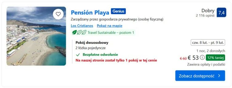
Hotel Andrea´s – [click]

Climate and weather in Tenerife
I have only good news in this paragraph :)
Tenerife is a perfect holiday destination all year round. The coastal part of the island has a subtropical climate, while inland it changes to Mediterranean. Daytime temperatures on the coast rarely drop below 20 degrees Celsius in winter, and in summer temperatures can be expected to be close to 30 degrees Celsius.
At night, the temperature usually ranges from 15 degrees Celsius (in winter) to 23 degrees Celsius (in summer).
It rains the least in May, June, July, August and September (statistically 1 day with precipitation per month, and the precipitation may last only a moment). In the remaining months, statistically, the number of days in which some rain may occur does not exceed 5. The rainiest month is December. Then 43 mm of water falls per month. For comparison, in Poland about 100 mm of rain falls in July.
More detailed information about the weather in Tenerife can be found in a separate entry: Tenerife - long-term weather: air and water temperature, climate, holiday and vacation weather.
WARNING!
Please remember that as you go up towards the Teide volcano and to the north and northeast you have to expect slightly cooler weather. The volcano is over 3700 m high, and for every 100 m increase in height, the temperature drops by 0,6 degrees Celsius. At the top of the volcano (relative to the coast), the temperature should be expected to be over 22 degrees lower.
A really short history of Tenerife
According to legend, when you walk on Tenerife, you walk through the remains of Atlantis. However, if we return to the facts, it is worth knowing that the discoverers of the island (1402), i.e. the Spaniards, found inhabitants with fair complexion, light hair and blue eyes. Inhabited by the Guanches (because this is the name we know them today, and this name was given to them by the Spaniards), the island was then divided into 10 kingdoms. The Spanish finally conquered the island in 1495. The Guanches were partly murdered and partly transported as slaves to Europe. The few surviving Guanches assimilated with the Spanish, and their language and culture disappeared completely.
The first capital of the island was a city founded by the Spanish La Laguna (Currently San Cristóbal de La Laguna), which is currently on the UNESCO cultural heritage list.
For a long time, the islands of the archipelago developed rapidly, serving as an intermediate port on cruises to the Americas, but over time they began to lose their importance. The worst moment in the history of the islands occurred during the government of General Franco, during which impoverishment was so deep that many inhabitants fled to Venezuela in search of a better fate. The situation began to improve in the 60s, when Tenerife was transformed into a tourist zone, which, fortunately for the island and us, we can still enjoy today.
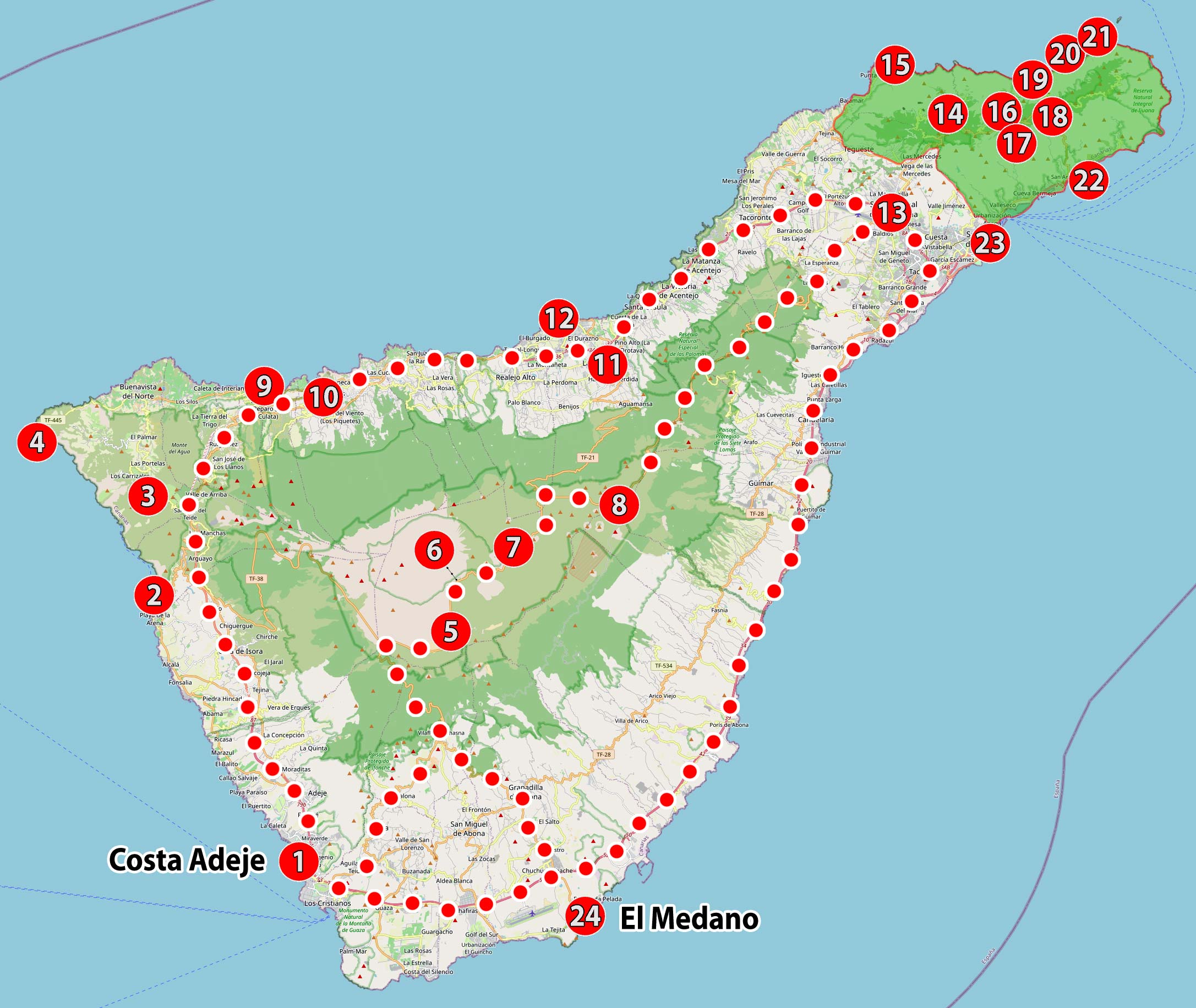
Map of attractions in Tenerife
It's time to start planning your visit to Tenerife. First of all, it is worth taking a moment to analyze the map of Tenerife's attractions that I prepared. I have included all the important points of attraction on the island and the routes of the main roads that you will undoubtedly use. The map below will be your main tool when planning your visit to Tenerife.
Of course, when visiting the island, you can look for other road connections and treat such a trip as an additional adventure, but before you decide to take a different route, first check the forecast travel time in the navigation. What sometimes looks encouraging on the map may, in practice, be difficult to implement and very time-consuming.
Each attraction marked on the map has its own number. Further in the text under this number you will find additional information related to a given attraction. It will be mainly a short description and some important information (if necessary).
Usually next to each attraction I put the GPS coordinates of the nearest car park and (if necessary) additional coordinates of key points that will help you get to the right place.
Use this data! They are very simple to use. Just click on the link next to them, and the navigation will start automatically and calculate the route to your destination (just don't forget to switch the navigation from driving mode to walking mode or vice versa).
Many of the attractions, in addition to the short description included in this plan, also have separate, more detailed studies. If they exist, you will find links to them in the descriptions. It is worth visiting them because they contain a huge amount of useful information, practical tips, additional photos, detailed maps of attractions, etc.
Tenerife sightseeing plan
There is no one best plan for visiting Tenerife, because our needs are different. However, you can try to create a plan that is flexible and universal, so you can adapt it to your needs. Below you will find just such a proposal for visiting all the most interesting attractions on the island.
The road communication system in Tenerife, including the main road leading around the island, allows sightseeing to be divided into several areas located near this loop. That's what I did. I divided the island into areas and grouped the attractions there into interesting one-day trips. So you get a ready-made plan that you can implement in any order, in the form of one-day trips. So you do what you want and how you want. Simple and convenient!
You can change your plans even at the last minute, depending on, for example, the weather (this is especially important when visiting the north-eastern part of the island, where the weather can be capricious).
Using my idea, the tour of Tenerife was cleverly divided into five days. Each day is well filled, but not excessively overloaded, so it should be possible to implement the plan even in the winter months when the days are shorter.
Now take a look at the map below. Even though it seems simple, it allows you to quickly and easily understand how exploring the island is organized.
Please take a moment to familiarize yourself with this map. Tenerife's main hotel base is located in the south of the island: Costa Adeje. Most tourists come and spend their free time here, so it is a natural starting point for trips. If you live elsewhere on the island, it won't matter much as each area can be reached quickly via the main road.
The routes I calculated for all five days provide distances and travel times from the same starting point, which is Costa Adeje. So if, for example, on the third day, the length of the route is 200 km and the travel time is 3 h 30 min, it means that the calculation includes the start from Costa Adeje, arrival and travel of the entire route and return to Costa Adeje. Travel times do not include attraction time.
On the map you can see the numbered attraction markers you already know, the location of the areas I selected for each day of visiting, the route of the main roads on the island (one convenient and fast one around the island, and one much more difficult, narrow and winding towards the Teide volcano).
Most tourists come to the island for a week, but in practice they have six days at their disposal. I developed a plan for five days. This one theoretically free day is very important. I have left it at the disposal of people who would like to go hiking through the Masca Valley. The walk itself lasts several hours and takes practically the entire day, so it cannot be combined with visiting other attractions. So if you are planning to trek through the Masca Valley, this free day will be very useful for you.
Day 1 – Los Gigantes, Masca and Punta de Teno
We start off strong. The attractions on the first day will be truly spectacular: huge cliffs Los Gigantes, brilliant view of the village and the Masca gorge and the beautiful coast at Teno Point. The ride is short, but very demanding. Most of the time you will travel along steep and winding mountain roads and every now and then (between the main points of the trip) you will stop at viewpoints. There are a lot of them and you probably won't miss them. I have provided their exact GPS coordinates in separate entries. Assuming that the stop at each viewpoint and the main attractions will take you some time, you can safely assume that the trip will last the whole day.
I would like to remind you that on this day there is no point in planning a walk through the Masca Gorge. The walk is long (total round trip time is approximately 8 hours) and physically demanding, and more details about it can be found in a separate entry – [click]
Attractions on the route: Los Gigantes (2) – Masca (3) – Punta de Teno (4)
Route length: 130 km (assuming we start and return to Costa Adeje)
Time of travel: 3h 15 min (does not include time to visit attractions)
Day 2 – Teide National Park
On the second day, we will visit the attractions located in the area Teide National Park. All attractions are centered around the volcano. This day has two key points related to the availability of entry tickets. The first one (easier) these are tickets for the cable car – [click], which will take us to the peak of the Teide volcano. It is worth taking care of them in advance, because the cable car has limited capacity and tickets disappear quickly. After arriving at the destination, it may turn out that the next available entry ticket is only a few hours away and you will not be able to use the most important attraction. The second problem is related to climbing to the top of the volcano. From the upper station of the cable car to the summit, it is only a few hundred meters, but the number of people who can get there is strictly limited. The cable car ticket does not give you the right to climb to the top. You must apply for this right in advance by reserving a specific time and day of entry in your name (the reservation is free of charge).
Both things (i.e. tickets for the cable car and the right to climb to the top) can be arranged online, and the directions to specific websites are provided later in the text and in separate entry about Teide – [click]
The remaining points on the tour route include a view and landscape point with fancy volcanic rocks (Mirador de la Ruleta), an area of the Martian landscape where space vehicles are tested (Minas de San José) and the world's third largest astronomical observatory for observing the sun.
Attractions on the route: Mirador de la Ruleta (5) – cable car to the Teide Volcano (6) – Minas de San Jose (7) – Teide Astronomical Observatory (8)
Route length: 180 km (assuming we start and return to Costa Adeje)
Time of travel: 3h (does not include time to visit attractions)
Day 3 – colonial cities in the north of Tenerife
The third day of sightseeing focuses on the northern coast of the island. We will see something unique in the world Dragon Tree (in Icod de los Vinos) and cozy and charming colonial towns: Garachico, La Orotava. If you are lucky and the weather is bad enough (yes, yes!), on the coast of Garachico and in Puerto de la Cruz you will see gigantic, multi-meter waves that crash on the rocky shores of the island with a huge roar (the mere memory gives me goosebumps).
Attractions on the route: Garachico (9) – Icod de los Vinos (10) – La Orotava (11) – Puerto de la Cruz (12)
Route length: 200 km (assuming we start and return to Costa Adeje)
Time of travel: 3h 30 min (does not include time to visit attractions)
Day 4 – Anaga nature park and mountains
On the fourth day we will visit San Cristóbal de la Laguna (13), the first capital of Tenerife, included on the UNESCO list, and then we will enter the landscape park and the mountain range anaga (14). Driving through the Anaga Mountains will be demanding for drivers due to strongly sloping and winding sections. Be prepared for this, stay patient, focused and don't rush anywhere!
The remaining points of the route I have planned are the town Hidalgo Point (15) with a nearby beach (Playa de los Troches), then amazing Tunnel de las Hadas (16) and then an easily accessible peak Pico del Ingles (17) with a viewpoint of the Anaga Mountains. At the end, we will return by a slightly roundabout but picturesque route through Devil's Spur (18)
Most of the route through the Anaga Mountains that day will be by road TF-12. This is the most interesting and scenically attractive route in these mountains.
Attractions on the route: San Cristóbal de la Laguna (13) – Anaga Natural Park (14) – Punta del Hidalgo (15) – Túnel de las Hadas (16) – Pico del Ingles peak (17) – Devil's Spur Rock (18)
Route length: 230 km (assuming we start and return to Costa Adeje)
Time of travel: 3h 45 min (does not include time to visit attractions and may be longer)
Day 5 – Anaga Mountains, the capital of the island and the largest sandy beach
It is very likely that on your first day in the Anaga Mountains you will fall in love with this place and you will not be satisfied with it. If this happens, I have a second day planned for you in the same mountains, but in slightly different places. It will be a picturesque town Taganana (19) and two extraordinary beaches: Almaciga (20) and Benijo (21). However, if you decide that you need rest, you can limit your sightseeing to the capital of the island Santa Cruz de Tenerife (23) and on the only sandy beach on the island Teresitas Beach (22), resulting from sand originating from the Sahara.
Attractions on the route: Taganana (19) – Almaciga (20) – Benijo (21) – Playa de las Teresitas (22) – Santa Cruz de Tenerife (23)
Route length: 215 km (assuming we start and return to Costa Adeje)
Time of travel: 3h 30 min (does not include time to visit attractions)

Descriptions of attractions in Tenerife
Below you will find really short descriptions of all the attractions visible on the map. I include GPS coordinates of key points in the descriptions, including parking lots allowing you to stay near the attractions. I encourage you to use them. Every driver will appreciate this convenience: you click your finger, the navigation starts automatically and you're off!
1. Costa Adeje
Costa Adeje is the name of the area on the southern coast of Tenerife, which includes several towns where most tourists who come to the island find accommodation. All towns together form one huge tourist center operating under one commonly known name.
Costa Adeje includes the following towns: Playa de las Américas, San Eugenio, Torviscas, Playa Fañabé, El Beril, Playa del Duque, La Caleta, El Puertito, Playa Paraíso, Callao Salvaje.
In this part of the island, average annual temperatures are: 24°C. In winter it is 23°C and in summer 28°C.
I included Costa Adeje in the sightseeing plan to have a reference point for calculating the length of routes and visiting times. Most of you will set off to explore the island from this place.
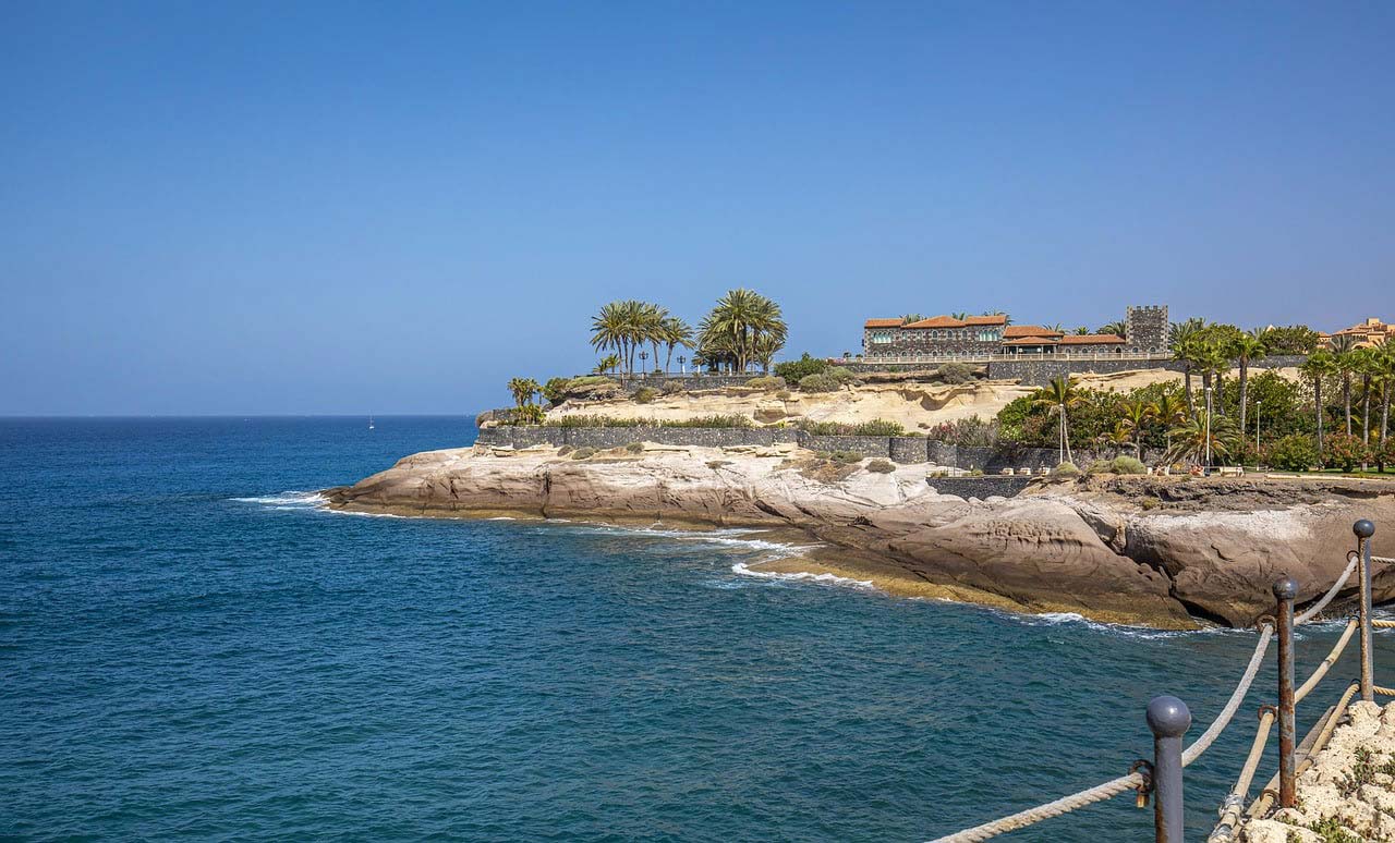
2. Los Gigantes
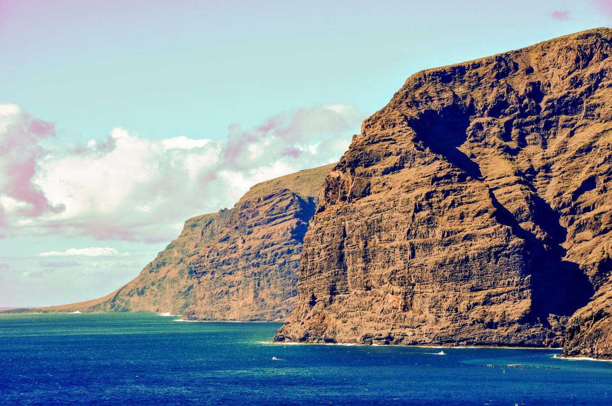
Huge rock cliffs, the size of which often gives you goosebumps. The monumental rock walls make a huge impression. More details about visiting Los Gigantes can be found in a separate entry: Los Gigantes – cliffs, beach, cruises
Viewpoint at the exit to the town of Los Gigantes, GPS coordinates:
28°14’25.1″N 16°50’12.4″W
28.240305, -16.836768 - click and route
An attractive viewing point located right next to the road. It's worth stopping because it's really well located. Parking takes place on the side of the road. The coordinates given are at the end of the parking lot, so look for a parking space about 100 meters in advance when the line on the hard shoulder changes from solid to dashed to your right.
One of the most interesting viewpoints on Los Gigantes, GPS coordinates:
28°14’56.1″N 16°50’17.7″W
28.248903, -16.838243 - click and route
To get to the point you have to walk about 100 - 150 m along a dirt path. You have to leave the car for a while somewhere in a narrow street. The street is a dead end and there are a few parking spaces at the end (maybe you'll be lucky). Below are the GPS coordinates of the point where you have to leave the street and go onto the dirt path.
Step off the street onto a dirt path to the viewpoint, GPS coordinates:
28°14’52.7″N 16°50’17.1″W
28.247983, -16.838090 - click and route
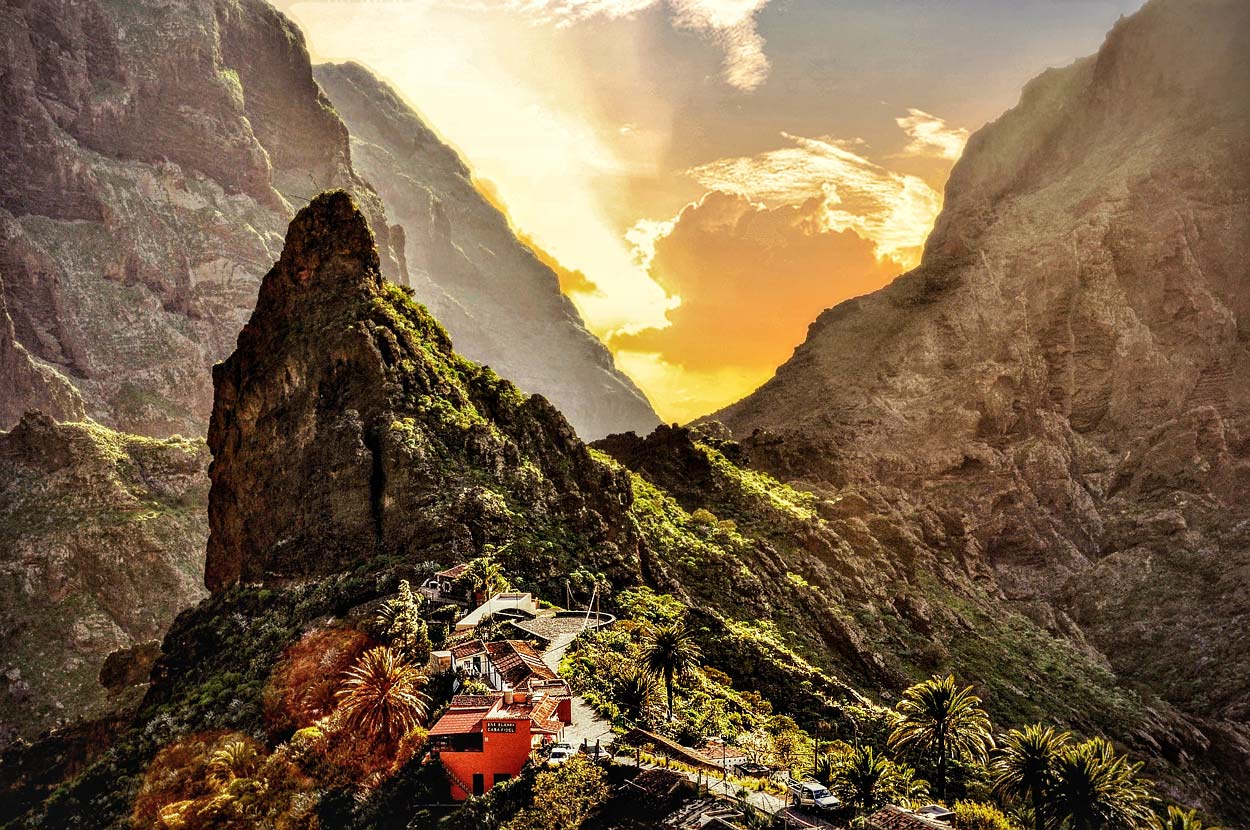
3. Chew
Many tourists come to the island just for this view (and for those available on the way to Masca). Arrival and visit to the village and the Masca gorge I described it in detail in a separate entry – [click], so I won't repeat it here. I'll just give you the coordinates of a small parking lot in the village, because that's the main place you need to go.
Parking in Masca (for tourists), GPS:
28°18’19.2″N 16°50’22.2″W lub
28.305330, -16.839490 - click and route
4. Punta de Teno
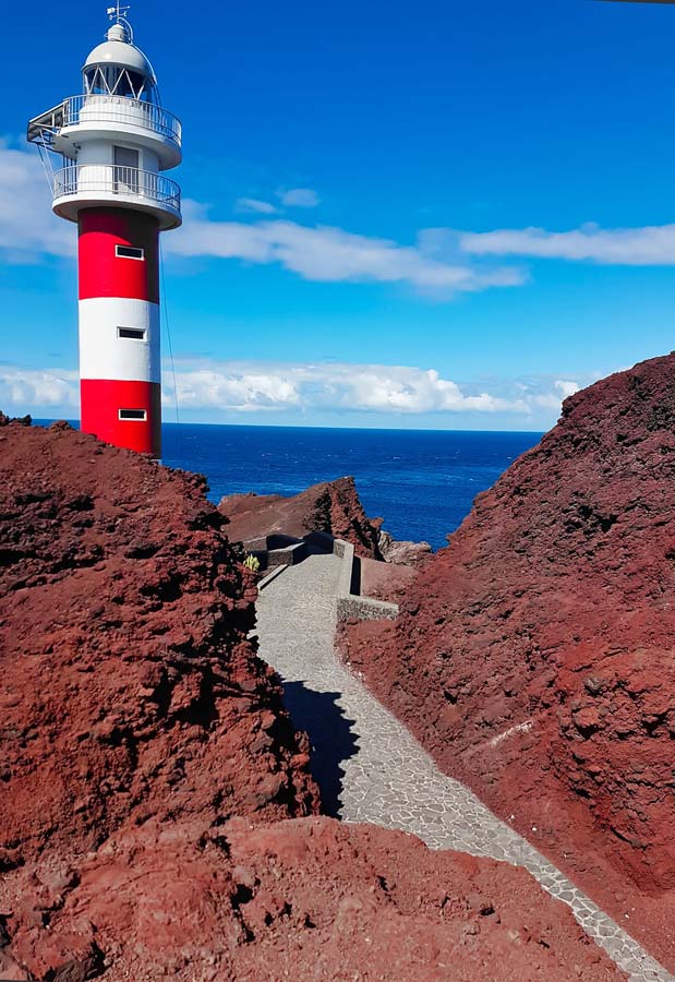
The Punta de Teno Peninsula is a real treat for travelers. It has everything that almost every wanderer probably desires, and certainly wants it at least for a moment during each trip: silence, soothing peace, wonderful nature and beautiful views of the surrounding rocks, mountains, cliffs ... A pure mix of nature and alienation, somewhere at the end of the land . Balm for busy and tired people.
Punta de Teno is the westernmost part of the land and is not easy to get to. It is true that there is a narrow, good quality road leading here and it is possible to travel comfortably by car, but this is not always possible. The locals are very strict about preserving the natural character of the peninsula and have limited the possibilities of traveling by car:
– during the summer season (April to September) the ride is closed from 9:00 a.m. to 20:00 p.m.
– outside the summer season (October to March), the ride is closed from 10:00 a.m. to 19:00 p.m.
When the gates are closed, you can use the local bus (I will write about this a little later, below).
Outside this time zone, the gate blocking the passage is open and you can reach the end of the peninsula by car. However, the question arises: if you pass the gate e.g. before 9:00 a.m., will you be able to leave again after 9:00 a.m.? Unfortunately, I haven't tested it myself, but the locals say that if you don't manage to return from the peninsula before the gates close in the morning at 9:00, you will have to wait until they reopen, i.e. until 20:00 p.m. 🙂
Access to the peninsula by bus
If you want to reach the peninsula when the gates are closed, you can walk the last section from the gates (you have to walk 6,5 km and it takes about 1 hour 40 minutes) or commute city bus number 369.
The first bus from the stop in front of the gates leaves around 10:20 (the starting stop of the line is in the nearby town of Buenavista del Norte and has the same name, the bus leaves at 10:10). Then the bus runs once an hour until the last departure at 18:15 (from the gates) or 18:05 from the starting stop Buenavista del Norte.
A bus ticket costs EUR 1 (2023 price).
The travel time of the entire route (from the center of Buenavista del Norte) does not exceed 30 minutes, and from the gates about 15 minutes.
For those interested (and to independently verify departure times), here is a link to the route and line map on the carrier's website: line 369 Buenavista del Norte – Punta de Teno – [click]
NOTE:
Before 20:00 p.m., a short queue of cars forms at the entrance gates wanting to enter the peninsula after 20:00 p.m. to admire the sunset. To catch the sunset, you need to arrive later at:
– April: 23:30
– May: 20:45
– June: 21:00 p.m
– July: 21:00 p.m
– August: 20:40
– September at: 20:09
The ride from the gates to the peninsula will take about 10 minutes, so in September you probably won't be able to make it in time for the sunset (unless the locals, knowing the problem, open the gate a few minutes earlier).
IMPORTANT:
There is no tourist infrastructure on Punta de Teno. No bars, restaurants, food trucks, or souvenir shops. There are also no toilets. You need to take care of the necessary things and needs in advance and have a supply of your own food and drink with you!
Small parking lot and bus stop 369 (stop name: Camino El Risco) in front of the gates blocking further travel, coordinates:
28°21’39.7″N 16°52’15.1″W
28.361034, -16.870847 - click and route
Parking lot at the end of the peninsula available when gates are open, GPS coordinates:
28°20’35.2″N 16°55’11.4″W
28.343112, -16.919831 - click and route
5. Mirador de la Ruleta
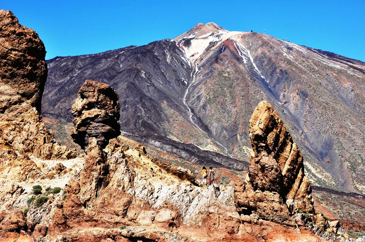
If you go to a souvenir and magnet shop in Tenerife, most of them will have a photo of the characteristic rocks from Mirador de la Ruleta on them. I was the owner of such a mug myself, but... after three cycles of washing in the dishwasher, the print disappeared and now I have an anonymous version of the mug from Tenerife. I adore him! It has a nice shape and the perfect capacity for me, but... the print of rocks from Mirador de la Ruleta is only a memory.
There is a comfortable walking path between the rocks, and right next to it there is a large parking lot, which ... is often completely full. The tour of the rocks doesn't take very long, so the turnover in the parking lot is rather quick. You probably just have to wait a while and something will become available.
Parking at Mirador de La Ruleta and Roques de García:
28°13’23.9″N 16°37’49.2″W
28.223310, -16.630338 - click and route
6. Teide volcano
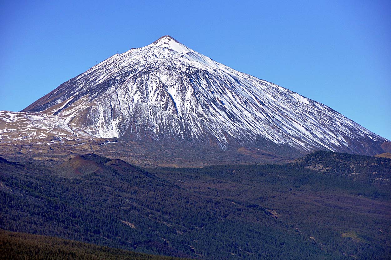
You can probably see it from every place on the island. The powerful volcano to which the island owes its existence is one of the most important and at the same time most difficult to access attractions on the island. Admission to Teide is very limited and if you plan to go up by cable car and visit the top of the volcano, be sure to read the entry I have prepared especially for you: Teide - cable car, tickets, trails, entry permit, weather. Teide National Park - attractions, excursions.
You will find all the information you need and a lot of tips that will help you organize your climb to the highest peak in Spain.
shortcuts for the impatient:
- tickets: cable car to Teide – [click]
- reservation: access right to the top of the Teide volcano – [click]
Teide – Parking lot at the lower cable car station, GPS:
28°15’21.4″N 16°37’28.1″W lub
28.255939, -16.624462 - click and route
7. Minas de San Jose
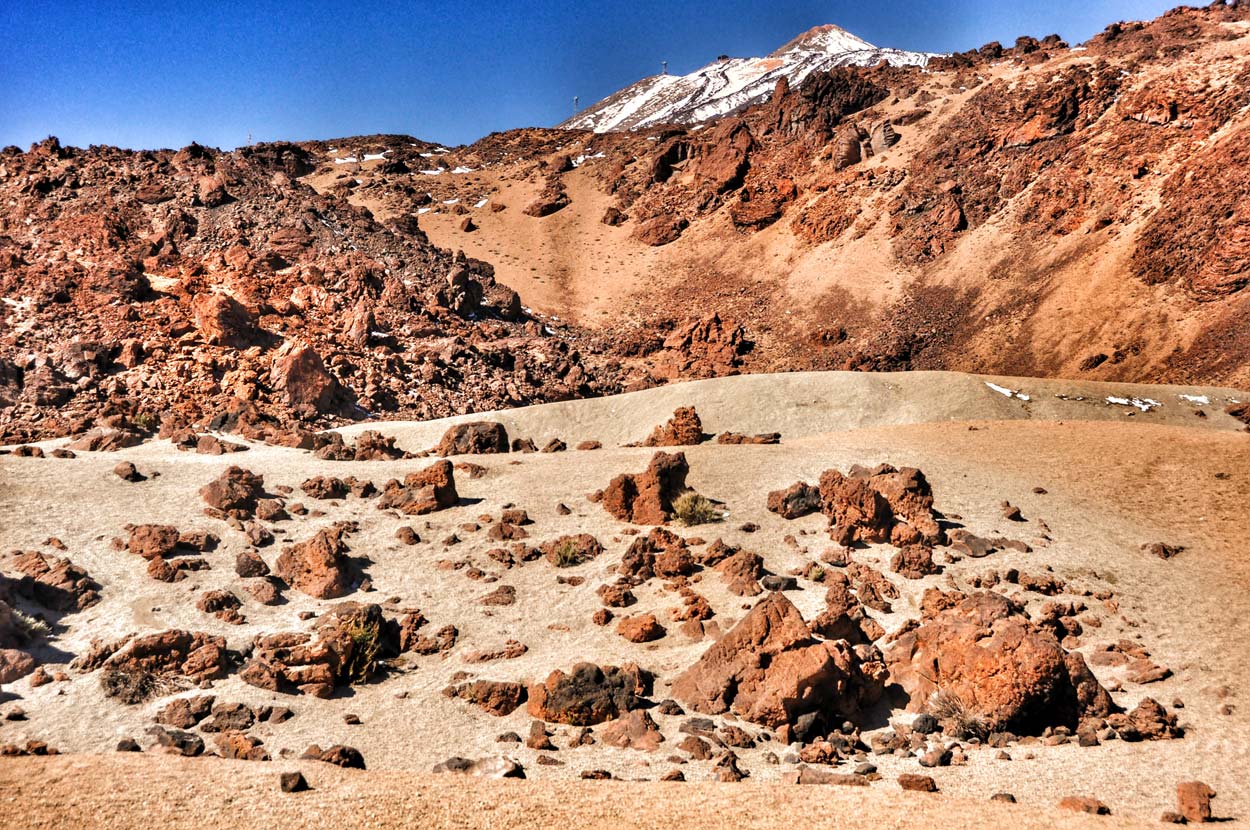
Visiting Minas de San Jose will save you a lot of time and money, because to see a similar landscape you would have to go... to Mars. This place is commonly known as the "Martian landscape in Tenerife" and this opinion is not exaggerated in any way. This is where tests of Mars vehicles are carried out before they are sent into space. If you want to know more, I invite you and recommend this fragment of the entry: Teide from space – [click]
Parking lot on the lunar-Martian plateau, GPS:
28°15’57.1″N 16°35’19.1″W lub
28.265859, -16.588645 - click and route
8. Astronomical observatory
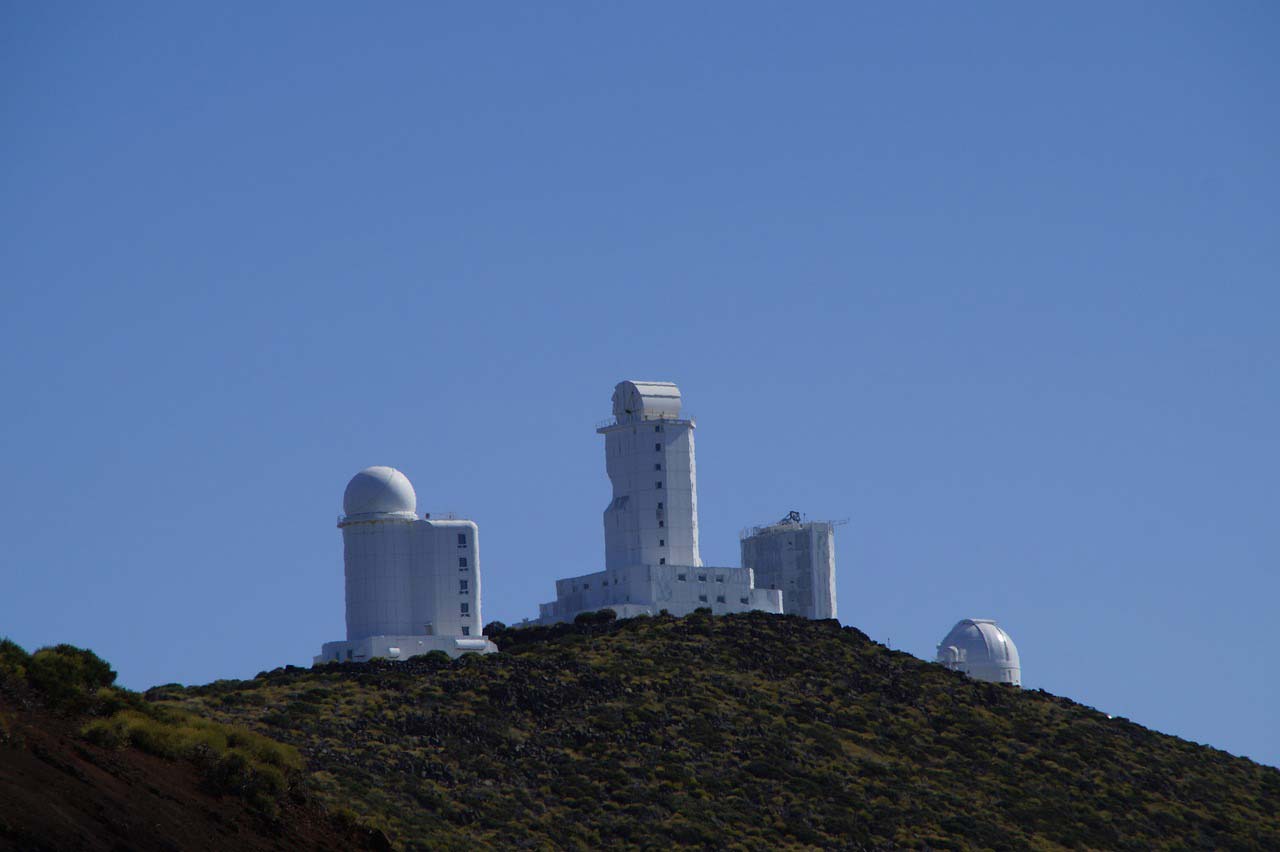
If you are very interested in space, a visit to the astronomical observatory, consisting of a large group of large observation telescopes, will certainly be a great attraction for you. The presence of such an extensive observatory in this place is, of course, not accidental. There are excellent conditions for observation on the slope of the extinct Teide volcano. The high location above sea level makes the atmosphere separating us from the vacuum of space much thinner, and therefore the image distortions caused by the air are much smaller. Added to this are low air pollution and a large number of cloudless days, and we have a great location for observing the sky.
The observatory in Tenerife specializes in solar observations and is the third largest facility of this type in the world.
Teide Astronomical Observatory, GPS coordinates:
28°17’52.4″N 16°30’34.9″W
28.297879, -16.509688 - click and route
9. Garachico
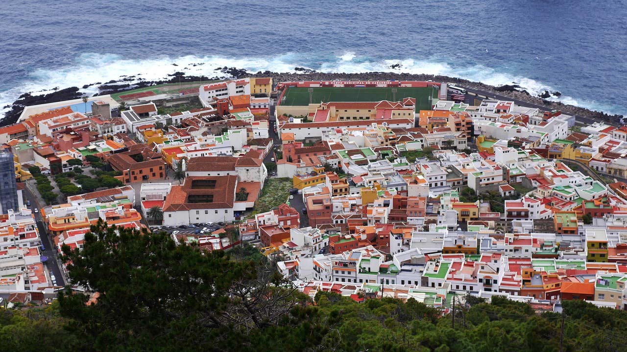
Garachico is a picturesque town. Paradoxically, its charm owes much of its charm to the disaster that almost led to its complete destruction. Founded at the end of the 15th century by a Spanish banker (Cristobal de Ponte), it developed dynamically, benefiting from a conveniently located and very popular port. Unfortunately, in a short time the city was hit by three disasters:
– recurring epidemics (probably arriving on ships anchored in the port),
– a huge landslide (claimed many victims and destroyed several ships),
– and finally (in 1706) the Teide eruption, during which lava flowing down the slopes destroyed a large part of the city and the main source of prosperity, the port.
Since then, the town has stopped developing and even shrunk, while retaining the charm of its colonial buildings.
The town is tiny, so you probably won't need a special guide. The coordinates of the main points are given below:
Parque de la Puerta de Tierra, i.e. the remains of the former gate leading to the port, GPS coordinates:
28°22’19.4″N 16°45’55.2″W
28.372058, -16.765331 - click and route
The main square, Plaza de la Libertad with colonial buildings, GPS coordinates:
28°22’23.5″N 16°45’51.6″W
28.373204, -16.764321 - click and route
Parking at the natural volcanic pools of El Caleton and the Castillo de San Miguel castle, GPS coordinates:
28°22’25.0″N 16°45’56.7″W
28.373602, -16.765757 - click and route
A point overlooking the town, at one of the access roads, GPS coordinates:
28°22’14.6″N 16°46’15.3″W
28.370719, -16.770905 - click and route
Unfortunately, you can't stop here and you have to stand about 150 meters away, or it's best to go higher, between the buildings.
Parking 150m from the point overlooking the town, GPS coordinates:
28°22’15.9″N 16°46’19.1″W
28.371083, -16.771965 - click and route
10. Icod de los Vinos
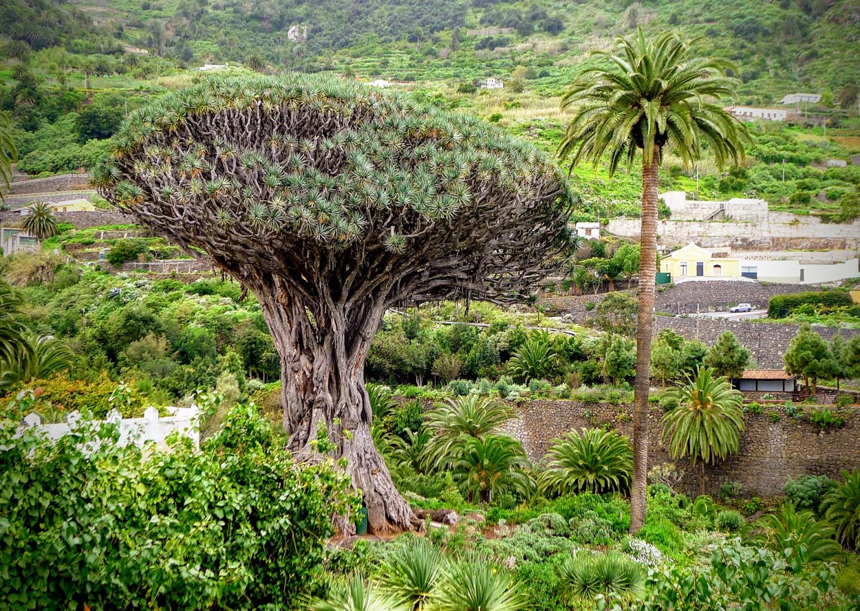
The town of Icod de los Vinos is famous for two things: firstly, it is the Thousand-Year Dracaena, also known as the Dragon Tree, and secondly, its colonial buildings. Why is dracaena so popular and important? Because it is the oldest known plant of this type in the world, and at the same time it is huge and beautiful. In short: unique in the world.
Admiring the colonial buildings of the town is not complicated, but to make it easier for you to visit Icod de los Vinos, I have prepared a special entry: Dragon tree from Icod de los Vinos - a living symbol of Tenerife
Parking near the Dragon Tree, GPS coordinates:
28°22’04.6″N 16°43’12.6″W
28.367936, -16.720177 - click and route
11. La Orotava
Many say that La Orotava is the most beautiful town in Tenerife. You may agree with it or not, but it is definitely a wonderful example of colonial architecture, and on selected holidays, when the inhabitants additionally decorate the city, it can really delight. It is definitely a place worth visiting and devoting some time to it. Quite by accident, on my blog you will find a separate entry dedicated to visiting La Orotawa. I invite you to read it: La Orotava - Tenerife: attractions, map, sightseeing and time travel to colonial times.
Parking in the center of La Orotava, GPS:
28°23’18.0″N 16°31’35.3″W
28.388326, -16.526470 - click and route
12. Puerto de la Cruz
It may be somewhat surprising that Puerto de la Cruz, located in the northern part of the island (i.e. the worse one), is primarily a tourist town. Hotels, a large selection of accommodation, cafes, restaurants, a promenade for tourists, an old pier, a complex of iconic seawater swimming pools and an extremely popular family amusement park Loro Parque ZOO with world-famous parrots and a whole lot of other animals... I guess it all speaks for itself.
Loro Parque ZOO It is very popular, especially in summer, but fortunately tickets can be purchased online – [click]. By the way, a photo gallery from the park is available at the link.
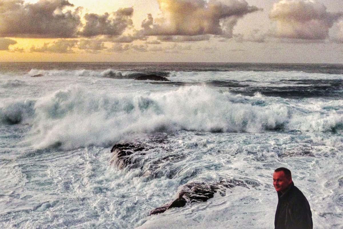
We came to Puerto de la Cruz to see huge ocean waves and we did it! We were very lucky because the waves were really powerful. The fleshy masses of water rising high furiously crashed against the rocky shore, making the ground tremble under our feet. The huge bang that accompanied it only intensified the impression so much that I still feel a chill when I remember those moments. Monstrous strength!
The phenomenon was undoubtedly facilitated by the fact that it took place in February, when the chance for such waves is greatest.
WARNING
If you like family amusement parks, there is another park in Tenerife: Siam Park. It is focused on family water entertainment: swimming pools, slides, places for varied relaxation. It is possible to purchase at a favorable price combined ticket to both parks: Siam Park and Loro Parque ZOO – [click]
The oldest building in the city: Casa de la Aduana, GPS coordinates:
28°25’04.8″N 16°33’00.3″W
28.417991, -16.550085 - click and route
Historical center and main square with restaurants, GPS coordinates:
28°25’00.7″N 16°32’55.3″W
28.416857, -16.548680 - click and route
Swimming pools and promenade, GPS coordinates:
28°25’09.4″N 16°32’36.6″W
28.419285, -16.543487 - click and route
Huge parking lot in Puerto de la Cruz, GPS coordinates:
28°25’06.6″N 16°33’06.4″W
28.418492, -16.551768 - click and route
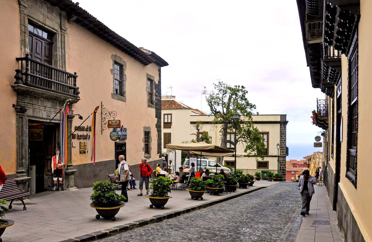
13. San Cristóbal de la Laguna
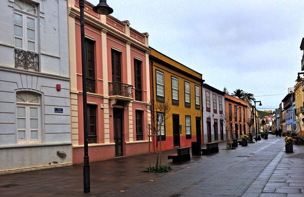
And so we reached the first capital of Tenerife, and at the same time a city inscribed on the UNESCO heritage list. The beautiful, colonial old town has retained its original 16th century layout and has basically not changed since it was built.
From the moment it was founded, San Cristobal was the main starting point for the further conquest of the island. It quickly became a central place gathering the most important institutions and social groups. It was then that the university that operates here to this day was established.
The main axis of visiting the city can be the quick plan I proposed, according to which we start from the main parking lot, heading to one of the main streets/pedestrian streets. Calle de San Agustin. Walking along this street towards the ruins of the church Convento de San Agustin we will pass by some of the most important monuments and then head towards the church Iglesia de la Concepcion. We go back from the church along the street Obispo Rey Redondo next to the only cathedral in the city and further to the square Adelantado Square from where it's just a few steps to the parking lot where we started our walk.
Of course, the entire route is lined with many interesting, historic buildings.
The GPS coordinates of the key points I mentioned above are included in the correct order below:
The beginning of Calle de San Agustin, GPS coordinates:
28°29’20.3″N 16°18’49.6″W
28.488970, -16.313769 - click and route
Ruins of the Convento de San Agustín church, GPS coordinates:
28°29’25.9″N 16°19’03.4″W
28.490536, -16.317606 - click and route
Church of the Conception, GPS coordinates:
28°29’25.0″N 16°19’14.6″W
28.490273, -16.320730 - click and route
Obispo Rey Redondo Street, GPS coordinates:
28°29’21.8″N 16°19’04.8″W
28.489401, -16.318011 - click and route
Cathedral of La Laguna, GPS coordinates:
28°29’20.4″N 16°18’59.2″W
28.488995, -16.316447 - click and route
Adelantado Square, GPS coordinates:
28°29’15.2″N 16°18’48.5″W
28.487568, -16.313463 - click and route
The most convenient parking lot is located near the historic city center, GPS coordinates:
28°29’17.5″N 16°18’45.3″W
28.488189, -16.312586 - click and route
Reserve parking, 200m from the previous one, GPS coordinates:
28°29’12.3″N 16°18’44.8″W
28.486739, -16.312450 - click and route
14. Anaga Rural Park (Parque Rural de Anaga)
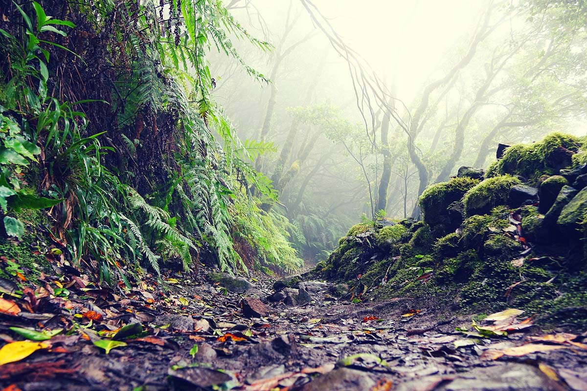
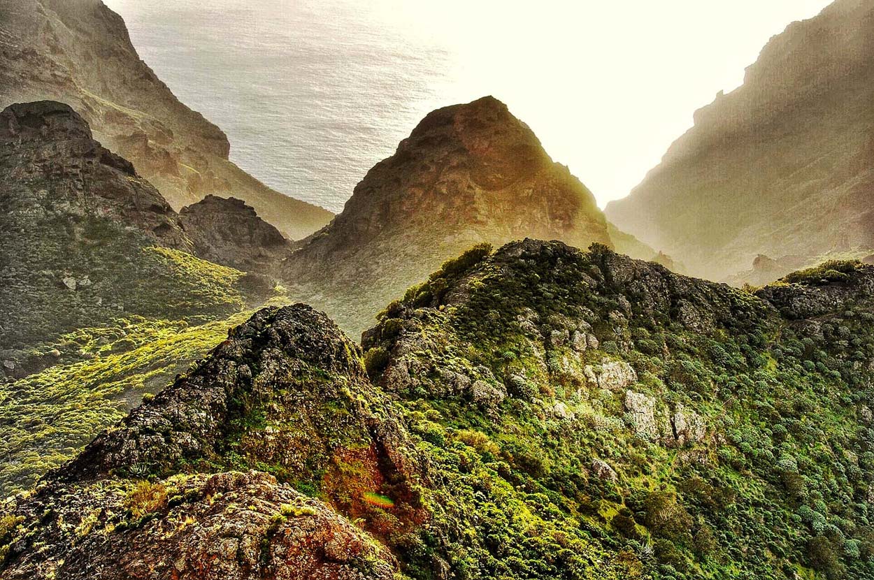
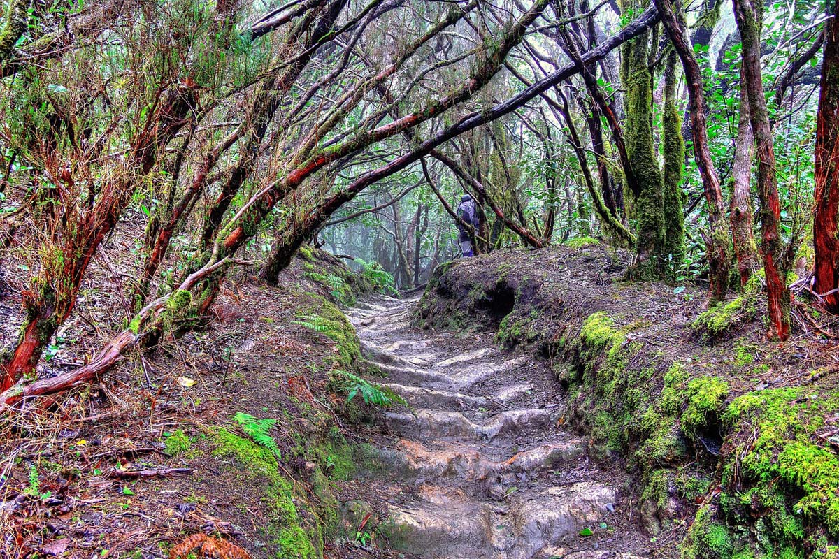
I actually included this point on the trip map just to put some information under it that I find very helpful. Anaga Rural Park, to which the name Anaga Landscape Park definitely better suits, is a real treasure of Tenerife. It is located on the north-eastern tip of the island, a place where the weather is often worse. Thick clouds and rain are not uncommon here, and temperatures below 20 degrees Celsius are normal. In addition, fog often appears, or rather clouds roll over the mountains, hanging so low that their bellies rub the mountains, which we see as thick fog. Thanks to this weather, the Anaga Mountains are free from crowds of tourists and are covered with fabulously lush vegetation. The conditions here are almost ideal for flora and fauna, which eagerly take advantage of it. It seems that the species that least notices the advantages of this area is humans. Needless to say, this situation creates a wonderful space for pleasant exploration. In recent years, more and more people have started to notice the Anaga Mountains Natural Park and more and more tourists come here, but it is still difficult to say that it is crowded.
A description of the sightseeing possibilities offered by the Anaga Mountains area is material for a separate, very extensive post, and unfortunately there is no space for it here. So I will try to condense what I may later develop in a longer text.
To start with, I chose a few places to include in my sightseeing plan, dividing it into two days (day 4 and day 5), but Anaga offers much more.
For all those who fall in love with this area and visit it at my suggestion, I am providing some additional information that will help them expand and expand their exploration of this area. You can explore Anaga not only by car, but also on foot. The entire area is covered with a network of specially marked and incredibly beautiful hiking trails. The trails have different lengths, different levels of difficulty and various purposes. There are those that you can walk on, but there are also those that are suitable and have been specially adapted for cycling and wheelchairs! Yes! There are such trails (information on the adaptation of the trail can be found in the list of trails below)!
- Parque Rural de Anaga trail map
First, the most important thing, a map of the trails. If you look carefully, you will find a lot of different maps on the Internet, but the most useful one seems to be the one I downloaded from the official website of Tenerife: www.tenerife.es. Mama is in PDF format and scales perfectly without major quality loss. Therefore, you can enlarge it greatly while maintaining very good readability and analyze the course of the trail you are interested in.
download: map of Parque Rural de Anaga – [click]
— List of hiking trails in the Anaga Mountains
To begin with, based on the data posted on the official website of Tenerife (tenerife.es), I have prepared a list of trails to which access is unlimited and does not require special permits. You can find the location of the trails on the map linked above.
Next to the descriptions you will also find the numbers of bus lines that take you to the beginning and end of the trail.
PR-TF 01 Las Mercedes – Cruz del Carmen
trail length (one way): 2,5 km
walking time (one way): 1h 20 min
access to the trail: bus to Las Mercedes from Intercambiador La Laguna – line 270
return from the trail: return bus from Cruz del Carmen to the La Laguna junction - line 273
see: more information
PR-TF 02 Taborno – Pico del Inglés – Valleseco
trail length (one way): 10 km
walking time (one way): 4h 30 min
access to the trail: bus to Taborno from the La Laguna junction - line 275
return from the trail: return bus from Valleseco to the Santa Cruz junction - line 917
see: more information
PR-TF 02.1 Trail connecting PR TF 02 with PR-TF 09 (via El Frontón)
trail length (one way): 0,5 km
walking time (one way): 20 min
access to the trail: bus to Taborno from the La Laguna junction - line 275
return from the trail: return bus from Valleseco to the Santa Cruz junction - line 917
see: more information
PR-TF 03 Casas de la Cumbre – Valle Brosque – Casa Forestal
trail length (one way): 6,5 km
walking time (one way): 3 h 45 min
access to the trail: bus to Casas de la Cumbre from the La Laguna junction – line 076
return from the trail: return bus from Casa Forestal to the La Laguna junction – line 076
see: more information
PR-TF 04 El Bailadero – Taganana
trail length (one way): 3 km
walking time (one way): 2 h
access to the trail: bus to El Bailadero from the La Laguna junction – line 077
return from the trail: return bus from Taganana to the Santa Cruz junction – line 946
see: more information
PR-TF 04.1 Amogoje – Almáciga viewpoint
trail length (one way): 2,6 km
walking time (one way): 1 h 30 min
access to the trail: bus to the Amogoje viewpoint from the Santa Cruz junction - line 946
return from the trail: return bus from Almáciga to the Santa Cruz junction – line 946
see: more information
PR-TF 05 Chamorga – Igueste de San Andrés
trail length (one way): 10 km
walking time (one way): 2 h
access to the trail: bus to Chamorga from the Santa Cruz junction - line 947
return from the trail: return bus from Igueste de San Andrés to the Santa Cruz junction - line 945
see: more information
PR-TF 05.1 Igueste de San Andrés – Traffic lights
trail length (one way): 2,2 km
walking time (one way): 1 h 25 min
access to the trail: bus to Igueste de San Andrés from the Santa Cruz junction - line 945
return from the trail: return bus from the traffic lights to the Santa Cruz junction - line 945
see: more information
PR-TF 06 El Draguillo – Chamorga – Anaga Lighthouse
trail length (one way): 7 km
walking time (one way): 4 h 40 min
access to the trail: bus to Chamorga from the Santa Cruz junction - line 947
return from the trail: return bus from Chamorga to the Santa Cruz junction - line 947
see: more information
PR-TF 06.1 Chamorga – Tafada Houses – Anaga Lighthouse
trail length (one way): 2,8 km
walking time (one way): 1 h 40 min
access to the trail: bus to Chamorga from the Santa Cruz junction - line 947
return from the trail: return bus from Chamorga to the Santa Cruz junction - line 947 or return from Almáciga to the Santa Cruz junction - line 946
see: more information
PR-TF 06.2 Roque de Las Bodegas – Almáciga – Benijo – El Draguillo
trail length (one way): 4,5 km
walking time (one way): 2 h
access to the trail: bus to El Draguillo from the Santa Cruz junction - line 946
return from the trail: return bus from El Roque de Las Bodegas to the Santa Cruz transfer hub - line 946
see: more information
PR-TF 06.3 Benijo – Cruz del Draguillo
trail length (one way): 2,2 km
walking time (one way): 1 h 50 min
access to the trail: bus to Benijo from the Santa Cruz junction - line 946
return from the trail: return bus from Cruz del Draguillo to the Santa Cruz transfer hub – line 947
see: more information
PR-TF 08 Afur – Taganana – Afur
trail length (one way): 14,5 km
walking time (one way): 9 h
access to the trail: bus to Afur from the La Laguna junction – line 076
return from the trail: return bus from Afur to the La Laguna junction – line 076
see: more information
PR-TF 09 Afur – Las Carboneras
trail length (one way): 5,7 km
walking time (one way): 3 h 30 min
access to the trail: bus to Afur from the La Laguna junction – line 076
return from the trail: return bus from Las Carboneras to the La Laguna junction – line 275
see: more information
PR-TF 10 Cruz del Carmen – Punta del Hidalgo [2023 – Trail under construction – possible temporary bypass]
trail length (one way): 10 km
walking time (one way): 4 h 30 min
access to the trail: bus to Cruz del Carmen from the La Laguna junction - line 273
return from the trail: return bus from Punta del Hidalgo to the La Laguna junction - line 105
see: more information
PR-TF 10.1 Degollada Las Escaleras – Las Carboneras – Chinamada
trail length (one way): 3,2 km
walking time (one way): 1 h 30 min
access to the trail: bus to Las Escaleras from the La Laguna junction - line 275
return from the trail: return bus from Las Carboneras to the La Laguna junction – line 275
see: more information
PR-TF 11 Cruz del Carmen – El Batán – Punta del Hidalgo [2023 – Trail temporarily closed for maintenance on the section between Lomo de Los Dragos and Batán de Abajo]
trail length (one way): 11,5 km
walking time (one way): 5 h
access to the trail: bus to Cruz del Carmen from the La Laguna junction - line 273
return from the trail: return bus from Punta del Hidalgo to the La Laguna junction - line 105
see: more information
PR-TF 12 Cruz del Carmen – Bajamar
trail length (one way): 10,5 km
walking time (one way): 4 h 15 min
access to the trail: bus to Cruz del Carmen from the La Laguna junction - line 273
return from the trail: return bus from Bajamar to the La Laguna junction - line 105
see: more information
PR-TF 12.1 Access to Tegueste (from the PR TF 12 route)
trail length (one way): 5,3 km
walking time (one way): 1 h 40 min
access to the trail: bus to Cruz del Carmen from the La Laguna junction - line 273
return from the trail: return bus from Tegueste to the La Laguna junction – line 050
see: more information
PR-TF 12.2 Access to Pedro Álvarez (from the PR TF 12 trail)
trail length (one way): 3,5 km
walking time (one way): 1 h 10 min
access to the trail: bus to Cruz del Carmen from the La Laguna junction - line 273
return from the trail: return bus from Pedro Álvarez to La Laguna junction – line 050
see: more information
— List of wheelchair accessible trails and family trails in the Anaga Mountains
The path of the senses
The trail is divided into three parts, with only part 1 fully accessible for strollers. The remaining two parts should be treated as not adapted for strollers, but I will provide data for all three sections because family paths will work well.
access to the trail: bus to Cruz del Carmen from the La Laguna junction - line 273
return from the trail: return bus from Cruz del Carmen to the La Laguna junction - line 273
Path of the senses – route 1 (part 1 only): “Awaken your senses”
length of the trail (one way): 0,2 km - the trail is practically flat and leads along a wooden platform
see: more information
Path of the senses – route 2 (part 1 + 2): “Let yourself be surprised”
length of the trail (one way): 0,9 km - only part 1 is passable by stroller
see: more information
Sensory Path – Route 3 (Part 1 + 2 +3): “What Monteverde Contains”
length of the trail (one way): 1,3 km - only part 1 is passable by stroller
see: more information
Pista de las Hiedras trail
length of the trail (one way): 4,4 km - only a part of the trail (the first kilometer) is passable for strollers
see: more information
15. Punta del Hidalgo
A picturesquely situated town on the border of the mountains and the ocean. another perfect place to just sit and watch. In Punta del Hidalgo itself, you can eat excellent seafood in brilliant scenery. Perhaps you will be here at a convenient time of day for a meal?
The following trails begin here: PR-TF 10 and PR-TF 11.
Viewpoint in Punta del Hidalgo, GPS coordinates:
28°34’16.8″N 16°19’04.2″W
28.571324, -16.317825 - click and route
see: panorama from the viewpoint – [click]
And here you can stop so close to the ocean that you simply can't get any closer, GPS coordinates:
28°34’23.5″N 16°19’52.2″W
28.573205, -16.331155 - click and route
16. Tunnel de las Hadas
photo: Regös Környei
A peculiar, unique and spectacular rock tunnel that is closed at the top by a vault made of tree crowns. The most beautiful photos are taken here when there is thick fog in the tunnel. The atmosphere then becomes doubly amazing.
Tunnel de las Hadas, GPS coordinates;
28°32’06.2″N 16°16’06.1″W
28.535049, -16.268361 - click and route
There is no way to stop at the entrance to the Tunel de las Hadas, so you can drive 150 m further, where there is a tiny bay, GPS coordinates:
28°32’04.2″N 16°16’01.7″W
28.534500, -16.267139 - click and route
17. Pico del Ingles
As the name suggests, Pico del Ingles is a mountain peak. Due to the fact that it is one of the highest peaks in this part of the island and its location has a very favorable view, there are few places from which you can see a more beautiful panorama of the mountains. Unless there is fog, the views will be amazing.
The PR-TF2 trail begins at Pico de Ingles.
Viewpoint on Pico del Ingles, GPS coordinates:
28°31’57.2″N 16°15’49.7″W
28.532550, -16.263792 - click and route
Parking on Pico del Ingles, GPS coordinates:
28°31’59.2″N 16°15’50.5″W
28.533113, -16.264023 - click and route
18. Devil's Spur Rock
Devil's Spur Rock is a characteristic permanent fragment with a road running along the edge. The view appears before us so unexpectedly that most often we have no time to react. So if you want to take a look at this interesting symbiosis of rock and road, slow down a moment before arriving.
Devil's Spur Rock, GPS coordinates:
28°32’47.7″N 16°12’52.0″W
28.546590, -16.214444 - click and route
19. Taganana
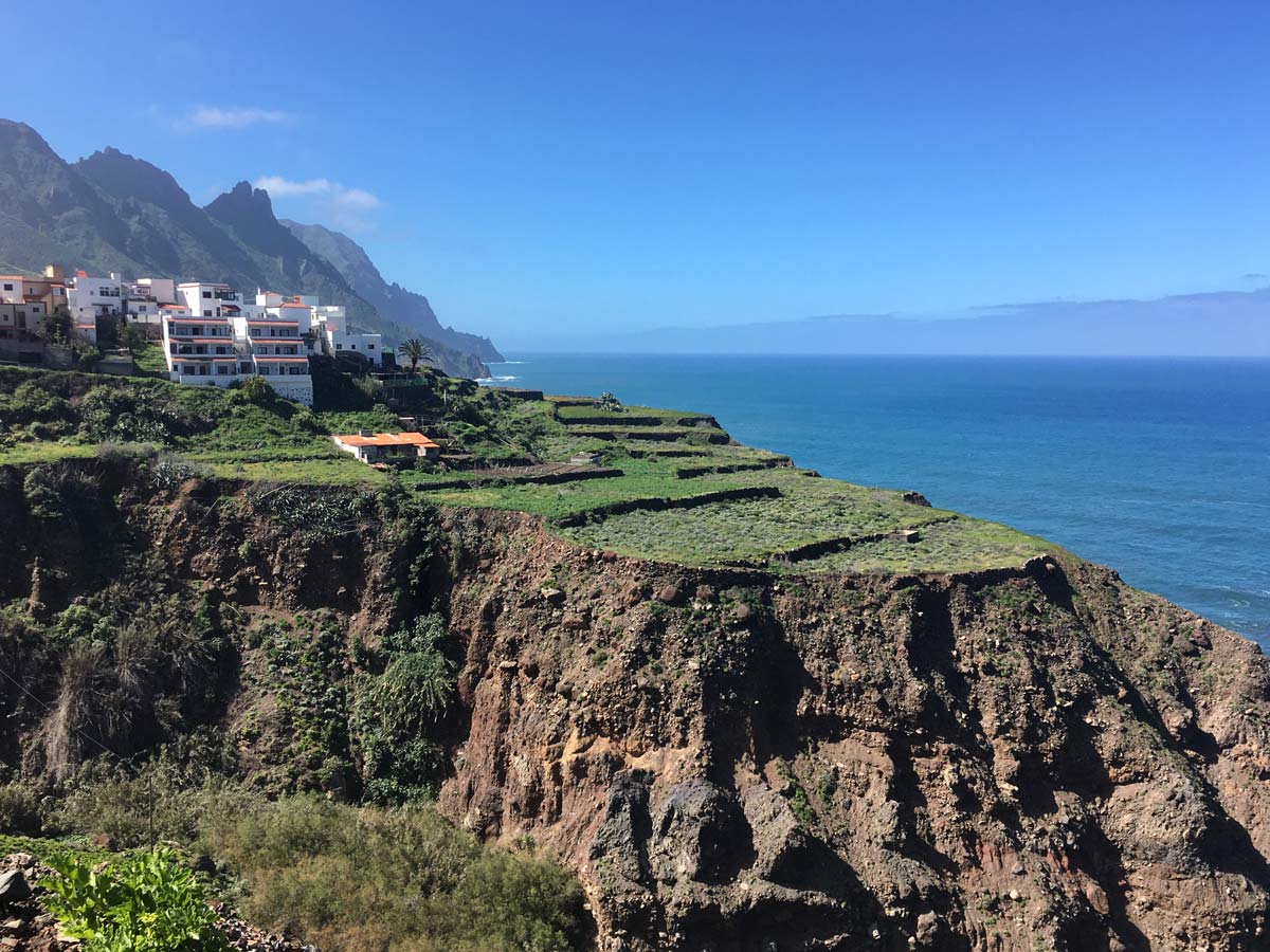
photo: Maria Bobrova
Taganana is a paradise for lovers of wonderful views, but a nightmare for drivers. Getting to this town is not easy, but the views make up for everything. You may hear the horn while driving. The road is so narrow and the turns so tight that drivers signal their presence when approaching a turn. This helps prevent dangerous situations on the road.
There are several viewpoints along the way (there are special bays), but there are also some that require driving, and the access road will be even more difficult. Take this into account and do not overestimate your skills and capabilities.
Mirador Túnel de Anaga viewpoint (on the way to Taganan), GPS coordinates:
28°32’51.3″N 16°12’11.2″W
28.547575, -16.203098 - click and route
Mirador Risco Amogoje viewpoint (on the way to Taganan), GPS coordinates:
28°33’29.7″N 16°12’20.4″W
28.558242, -16.205678 - click and route
At this viewpoint (Piedra Rajada) leads to a slightly breakneck entrance, GPS coordinates:
28°33’40.5″N 16°13’23.5″W
28.561261, -16.223205 - click and route
Oceanfront parking lot, where the driver can rest a bit, GPS coordinates:
28°34’01.0″N 16°12’48.7″W
28.566938, -16.213526 - click and route
20. Playa de Almaciga
Almaciga is one of the black beaches of which you will find many more in Tenerife. It is located near the previous point and it is worth visiting it at the same time. What distinguishes it from other beaches is the circumstances and surroundings in which it is located. Is there anything else that will impress you after a whole day filled with beautiful views?
Playa de Almaciga – short roadside with parking option, GPS coordinates:
28°34’14.7″N 16°12’13.1″W
28.570750, -16.203639 - click and route
21. Benijo
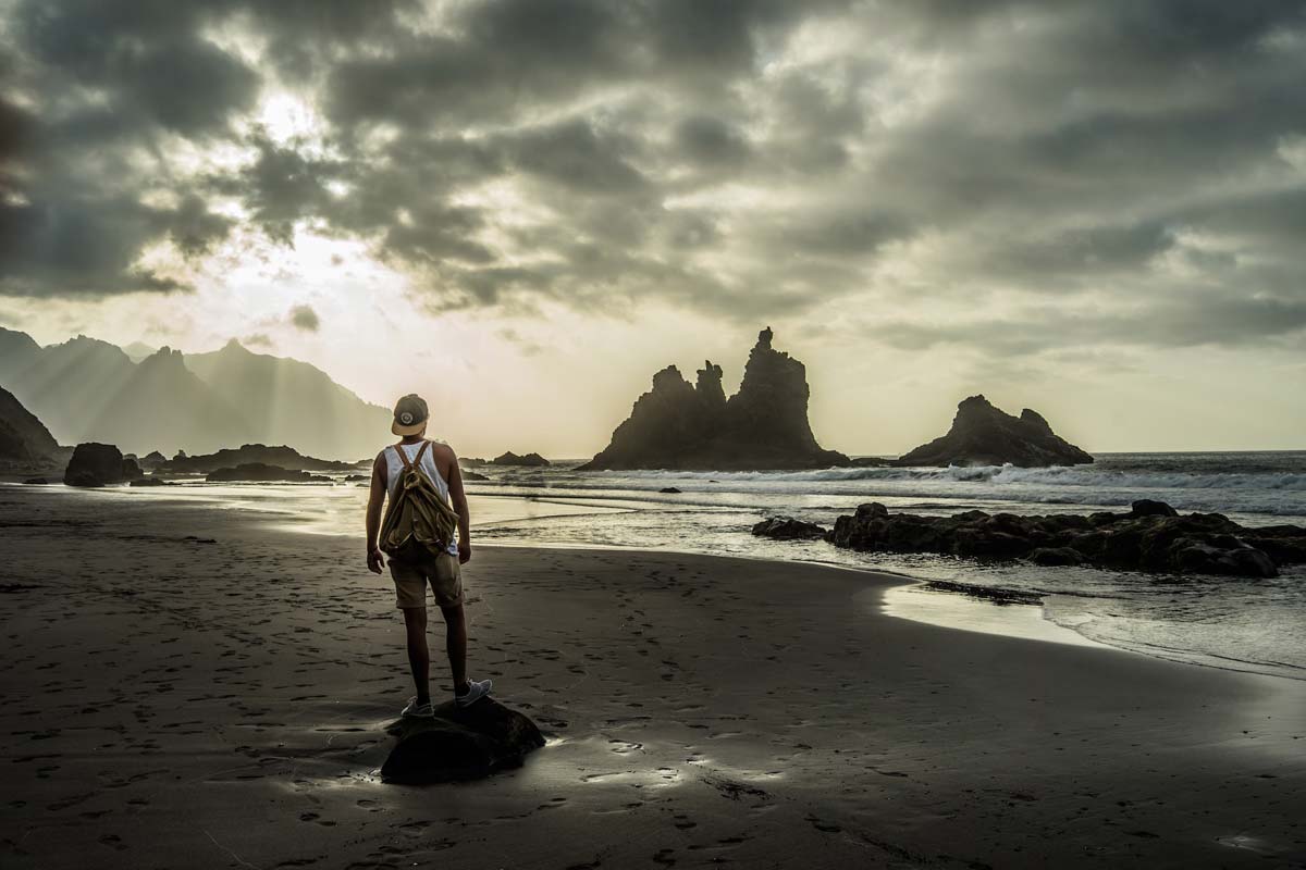
photo: Julian Hanslmaier
Benijo beach is always among the most beautiful beaches in Tenerife, thanks to the picturesque rocks on its shore. It is difficult to deny its charm and it is difficult to argue with the beauty of the natural coastal rock sculptures. I won't even try to describe them. Just go, sit down and enjoy the view.
The PR-TF 6.2 and PR-TF 6.3 dishes correspond to Benijo beach, which are then connected to PR-TF 6.
A small parking lot near the entrance to Benijo beach, GPS coordinates:
28°34’28.6″N 16°11’18.0″W
28.574621, -16.188325 - click and route
22. Playa de las Teresitas
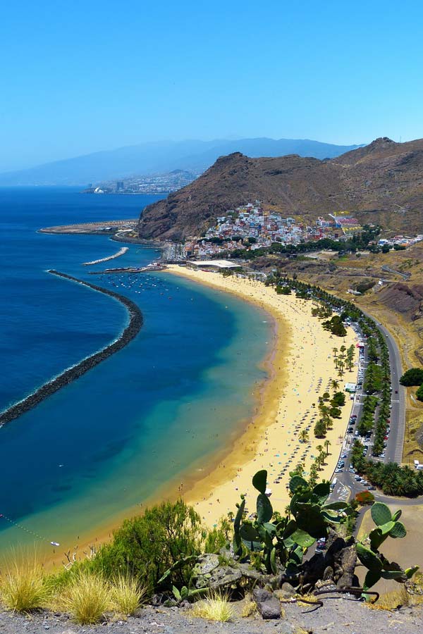
The largest sandy beach on the island. The dog on the beach comes straight from the African Sahara. In the vicinity of the beach there is a complete and extensive catering and sanitary facility.
Parking at Playa de las Teresitas beach, GPS coordinates:
28°30’28.9″N 16°11’17.5″W
28.508017, -16.188194 - click and route
23. Santa Cruz de Tenerife
Santa Cruz de Tenerife is the largest city in Tenerife and the second largest (after Las Palmas in Gran Canaria) city of the Canary Islands archipelago. Together with Las Palmas, it serves as the capital of local autonomy. Currently, over 220 people live in Santa Cruz de Tenerife. people.
The easiest way to explore Santa Cruz de Tenerife is to focus on a few of the most important squares and places. They can be easily arranged into a loop in the following order (the coordinates of all points are given below):
1. Castillo de San Cristobal castle
2. Plaza de España square
3. Plaza del Príncipe de Asturias square
4. Parque García Sanabria park
5. Plaza Weyler
6. return to Castillo de San Cristobal
You can leave your car in the parking lot near Plaza de Espana (GPS coordinates below).
Entrance to the public parking lot at Plaza de Espana, GPS coordinates:
28°28’02.8″N 16°14’47.6″W
28.467434, -16.246556 - click and route
Plaza de Espana and Castillo de San Cristobal (fragments can be seen in the underground gallery), GPS coordinates:
28°28’00.9″N 16°14’48.8″W
28.466905, -16.246900 - click and route
Plaza del Príncipe de Asturias, GPS coordinates:
28°28’05.9″N 16°15’01.4″W
28.468309, -16.250387 - click and route
García Sanabria Park, GPS coordinates:
28°28’18.7″N 16°15’13.4″W
28.471867, -16.253724 - click and route
Weyler Square, GPS coordinates:
28°28’03.6″N 16°15’20.5″W
28.467655, -16.255682 - click and route
Those interested can take a short walk near the characteristic building Tenerife Auditorium, next to which there is a round fortress on the water Castle of St John the Baptist, a complex of recreational and relaxation swimming pools César Manrique Maritime Park and palmetum, a famous garden with hundreds of species of palm trees.
All facilities are exactly next to each other, one next to the other, and there is a huge parking lot right next to it.
Parking at the swimming pool complex, GPS coordinates:
28°27’16.8″N 16°15’18.8″W
28.454671, -16.255234 - click and route
Auditorio de Tenerife and Castle of St John the Baptist, GPS coordinates:
28°27’20.9″N 16°15’07.4″W
28.455816, -16.252043 - click and route
Swimming pool complex, GPS coordinates:
28°27’14.7″N 16°15’15.9″W
28.454090, -16.254414 - click and route
Viewpoint in Palmetum, GPS coordinates:
28°27’09.4″N 16°15’16.8″W
28.452611, -16.254667 - click and route
At the end, you can still drive to the viewpoint from which you can see a vast panorama of the city.
Viewpoint overlooking the panorama of Santa Cruz de Tenerife, GPS coordinates:
28°28’31.5″N 16°15’38.0″W
28.475419, -16.260549 - click and route
24. El Medano
El Medano is one of the largest tourist and hotel centers near Costa Adeje with comfortable beaches. I am marking it on the map because some of you may have your base here, so having this point on the map will make it easier to plan your sightseeing.
Parking by the beach in El Medano, GPS coordinates:
28°02’45.7″N 16°32’03.2″W
28.046013, -16.534211 - click and route
Important to me!
Give the article a good rating (5 stars welcome 😀)!It's free, a for me it is very important! The blog lives on visits and thus has a chance to develop. Please do it and ... thank you in advance!
If you like my guides, you will certainly find the one I created useful guide catalog - [click]. There you will find ready-made ideas for your next trips, descriptions of other tourist destinations and an alphabetical list of guides divided into countries, cities, islands and geographical regions.
I also post link to Facebook profile - [click]. Come in and press "Follow"then you will not miss new, inspiring posts.
Unless you prefer Instagram. I'm not a social media demon, but you can always count on something nice to look at on my instagram profile - [click]. The profile will gladly accept any follower who likes it.
I make the content I create available free of charge with copyright, and the blog survives from advertising and affiliate cooperation. So, automatic ads will be displayed in the content of the articles, and some links are affiliate links. This has no effect on the final price of the service or product, but I may earn a commission for displaying ads or following certain links. I only recommend services and products that I find good and helpful. Since the beginning of the blog's existence, I have not published any sponsored article.
Some of the readers who found the information here very helpful, sometimes ask me how you can support the blog? I do not run fundraisers or support programs (type: patronite, zrzutka or "buy coffee"). The best way is to use links. It costs you nothing, and support for the blog is self-generating.
Pozdrawiam

Thank you for such a beautiful guide to the island, best regards.
Please kindly!
The best, comprehensive description of attractions with location data. Perfect convenience for independent tourism! This should be standard for everyone who describes tourist attractions. Great respect for real and competent work. A true example of real work!
You simply rock - the whole of Tenerife is beautifully described. Thanks 😉
This article is so well constructed that I don't even know what to write. Hats off for the quality and formation, detailed descriptions of places and details... thank you. He will be my main helper when planning the trip.
A super prepared guide to Tenerife. Especially for those who do not want to look for interesting places and directions on how to get there or where to park their car. In my case, very useful. Thank you and I recommend.
The quality of this guide blew me away. I haven't seen such good work on the Internet for a long time, refined down to the smallest detail. You can see how much work you do. I thank you for that!
One riječju: Svaka čast!
Pratim te za daljnja putovanja.
Brilliant!! As you would say in Spanish! I've already been there once, but now I know what I didn't have time to see and I also know exactly how to get there in 10 days :) Big GRATIAS! for this article
Hats off, thanks to your work we can save a lot of time.
Thank you very much, fantastic guide, great work.
In my opinion, the best guide available on the Internet. Congratulations! Gratitude for preparing it :)
Hello - the BEST and most accurate, comprehensive description of Tenerife. I admire the amount of work and congratulations on such a blog. I will recommend it, because "branded" guides are weak compared to it.
Pozdrawiam
I am grateful to
Well, for me it's the bomb
Rich content, linked topic developments! Stroke!
I liked it on Facebook and maybe I will travel more often with your travel tips!
I am sending greeting and I wish you good luck!
Tenerife in 1 day? 🙂 what to choose when it comes to sightseeing? I will be grateful for your advice :)
Petard! This should be published as a book! Not only is it a good read, but it's also full of useful stuff! Thanks so much especially for taking the time to do this!
Thank you for a very informative and inspiring article! It will definitely be the basis for planning our stay on the island <3
Great job! Very useful article :)
The best guide to Trenyf I have ever come across - a huge plus for the provided coordinates, links and tips regarding parking, as well as a well-thought-out grouping of sightseeing options - we will definitely use it and thank you! 👍
Great description, thank you very much 😁
Class! Everything you need in one place. Respect for the great job, everyone needs some work!
I spent a few days preparing a 10-day itinerary. I wish I had looked here earlier. In my case, I will spend 2 days in each of these beautiful places with my wife, saving travel time from one location. Wonderfully prepared material. I congratulate you.
Great material, we'll use it!
We bought tickets and I was looking for a guide on where to start sightseeing and what interesting things we can see in a few days in Tenerife. I came to the perfect place, thank you for the great guide.
excellent and professional guide
I used your article about Iceland, it was very useful. So now I read about Tenerife. I really want to go to its northern part. Thanks for the inspiration.
I am a tour leader and this is the best text I have ever read about Tenerife :) Very useful information. Thank you for the inspiration and best regards
WOW! And it's all in front of me. Fantastic text, lots of helpful information. 🙂 I will be looking for more guides. And just like Mr. Jacek, I am also annoyed by looking for parking spaces. Many thanks, I haven't found SUCH an introduction and description on other websites.
The most useful post about Tenerife I have read. THANK YOU !
Super useful text. I'm currently planning a trip to Tenerife and I'm getting excited reading this text :) it's great that the coordinates are indicated. Thank you
I use this entry while in Tenerife. Very substantive and systematic material, thank you, I will use the links.