
Andalusia attractions, MAP and sightseeing plan [2026]. What to see?
Andalusia is one of Spain's most fascinating regions, full of spectacular monuments, whitewashed towns, Moorish palaces, beautiful beaches, and extraordinary landscapes. If you're planning a visit to Andalusia and wondering what to see, below you'll find a map highlighting the main attractions and a suggested itinerary. It's a good starting point for planning a trip through southern Spain—from Malaga and Granada, through Seville and Cordoba, to Cadiz, Gibraltar, and more off-the-beaten-path destinations.
Andalusia – a tourist diamond mine
The longer I explored Andalusia, the closer I came to the moment when this very term appeared in my head: a tourist diamond mine. I admit that when I first arrived in this area I had no idea how many and what quality attractions awaited me here. Every day I set out to conquer new places, I visited them, and my legs became more and more weak from the impression. As I delved deeper into the subject, I kept coming across more and more places that were worth seeing, and in the end I ran out of time to visit everything. It doesn't matter - I thought. I'll just come here again.

The guide I decided to write collects the most important and interesting places in my opinion into one amazing journey. This is the essence of Andalusia. For two weeks, something spectacular and unique happens every day. The accumulation of impressions is really big, and the variety of attractions is as wide as possible. Absolutely unique works of art created by nature mix with outstanding works of human hands and mind. I assure you that many times you will have to think to yourself that what you are seeing is simply impossible. It will seem so, but everything will really happen! And everything will be wonderful except for one thing ... the adventure will end someday, and you will miss Andalusia forever!
Are you ready to take on this challenge? Then I invite you!
WARNING!
The guide you are about to read works closely with interactive PDF map of Andalusia – [click]You can download the map to your phone or print it out and keep it with you throughout your trip.
Map points are active! Click on them for more information.
Where is Andalusia?
Spain is divided into 50 provinces, and the structure of the Spanish system is such that each province has the right to enter into unions with other provinces, creating larger communities called autonomous communities. All Spanish provinces have made use of this right and currently each of them is a member of a larger autonomous community (there are 17 autonomous communities). This is how Andalusia was created, which is an autonomous community formed by eight provinces: Almeria, Cadiz, Cordoba, Granada, Huelva, Jaen, Malaga and Seville.
The capital of the community is Seville, where the Community Government and Parliament have their seat. The seat of the Community Supreme Court is Granada.

Here is the location of Andalusia on the map of Europe.
Below you will find a map of Spain, where I have marked the borders of all 17 Spanish autonomous communities, and Andalusia, located in southern Spain, is highlighted in red. On the map, I have also marked the location of the capital of the community (Seville) and Malaga, which is a major air hub due to its coastal location.

As a curiosity, Andalusia is the most populated (in terms of number of inhabitants) community in Spain, and in terms of area it ranks second. It is not hard to guess that it is also one of the strongest Spanish communities and therefore has a lot of autonomy.
Before we begin planning anything related to visiting Andalusia, it's worth understanding the actual dimensions of its territory. The first comparison can already be seen on the previous map. It shows 17 Spanish communities, with Portugal juxtaposed to the left of Spain. Take another look at this map and compare the areas occupied by Andalusia and Portugal. You see that, right? Andalusia is roughly the size of Portugal! So let's understand the actual dimensions of this area.

As you can see on the map above, we will be exploring a fairly large area measuring 520 km by 300 km. It will be necessary to plan accommodation and the order of sightseeing really well. We do not want to spend too many hours in the car and travel hundreds of unnecessary kilometers.
How to visit Andalusia?
In my opinion, there are two reasonable ways to explore Andalusia: public transport or a rental (or your own) car.
Public transport
Andalusia is well-connected. Getting between the main centres shouldn't be a major problem or challenge. Of course, it will take more time and introduce a few restrictions, mainly due to the need to adapt your activities to the timetables, but it will allow you to reach the most important places. Unfortunately, there are also places that will be difficult to reach by public transport. These are mainly places located far from the main urban centres, such as Caminito del Rey or some of the "white towns".
It is also important to be clear that if you decide to travel by public transport, you must immediately eliminate about half of the attractions I have suggested from your plan. Travelling will simply take you much longer and there is no solution to this.
In this guide, I won't focus on describing public connections because I haven't used them myself. So I won't talk about something I haven't tested in practice.
For those interested in this form of travel, I can only suggest that the website can make planning journeys and purchasing tickets much easier. Omio – [click], which allows you to check timetables, bus, train, flight and ferry connections. Although I usually rent a car, I have used it several times Omio and I admit that purchasing tickets there is simple, fast and clear.
Strona Omio is available in several languages, so there is no language barrier when using it.
Own or rented car
I don't like wasting time and I value the freedom and independence that having my own means of transport guarantees me. If possible, I always rent a car. This way, I am not limited to looking for accommodation near transport hubs, nor to the time I have to get back to the hotel to catch, for example, the last connection.
Sometimes I choose accommodation outside the city in agritourism, which at good prices can provide me with much greater comfort. At the same time, being slightly away from the main tourist traffic, it is much easier to feel the local atmosphere. I love sitting somewhere in the countryside having dinner with a view of the hills over which the sun is just setting and leisurely sipping local wine.
Spain has a well-developed car rental network and is one of the countries where renting a car is relatively inexpensive. So, I definitely recommend using your own transportation. If you live far enough away that you can't get there by car, simply rent a car at the airport. I've prepared a short guide on renting a car in Spain – [click] . With my guide, renting a car isn't difficult or complicated, and it's also very safe (as long as you choose the right insurance). You just need to know how! I encourage you to read it.
If this short guide is not enough for you, you can always check out the extensive description of car rental in Malaga – [click] , along with direct contact details to the local rental companies I have verified.
Need a car in another city? This Malaga guide includes universal advice that will help you rent a car in the same way in other cities!
Accommodation in Andalusia
Andalusia has excellent accommodation options, but searching them is incredibly time-consuming. However, there's room for improvement here, too. I'll include helpful links in the descriptions of attractions to make your search easier . I've designed the links so they include filters that present offers from the location you're interested in and block offers you're not interested in, such as those from far-flung destinations. It's worth starting your search with these links; they save a lot of time.
If you find a link to a specific hotel in the descriptions, do not treat it as a suggestion of a selected accommodation that I recommend. In this way, I only use the search engine mechanism, which, in addition to a specific hotel, always offers other, similar offers, often more attractively priced. This is also a way to avoid constantly filling in search forms. After one click, you get a ready list of interesting hotels from this specific location.
Travel Insurance (Is It Necessary?)
I don't want to spend too much time on this topic, so I'll be really specific. I'll be brief: I never leave home on a trip alone without insurance. On a trip we are constantly moving to new places, our heads are occupied with delights and other pleasures. We are more relaxed and it is not difficult to have an adventure. Lack of insurance is asking for serious trouble.It is also worth remembering that the so-called EHIC, i.e. the insurance that we have as citizens of the European Union, does not reimburse everything. It only reimburses what is reimbursed in a given country (e.g. in France, 35% of the costs of state rescue services are paid out of pocket). We could go into details for a long time, but doing so is pointless, because a solid weekly insurance for one person in Europe, compared to the cost of the entire trip it's surprisingly cheap. You can easily find really good deals for around 10-15 EUR total for the whole week (!!!), which is the equivalent of two or three beers.
I usually look for the best deals in this area offer comparison - [click] (in this case it's Rankomat) and I buy them online. You can do it really quickly and cheaply.
Below is an example of a good and not at all the cheapest offer from a price comparison site (for an entire week in 2025).

Two parameters are key in the offers:
- goat goat (KL) - the minimum amount is PLN 250 (EUR 000)
- Civil protection (OC) - the minimum amount is PLN 250 (EUR 000)
it is worth paying attention to two additional parameters:
- Consequences of Accidents (NNW) - at your discretion
- travel luggage insurance - at your discretion
Andalusia - map of attractions
go to: download page for the PDF interactive map of Andalusia – [click]
Are you using my logistics data, GPS coordinates or NaviG PDF maps for your trip?
Read this MUST!
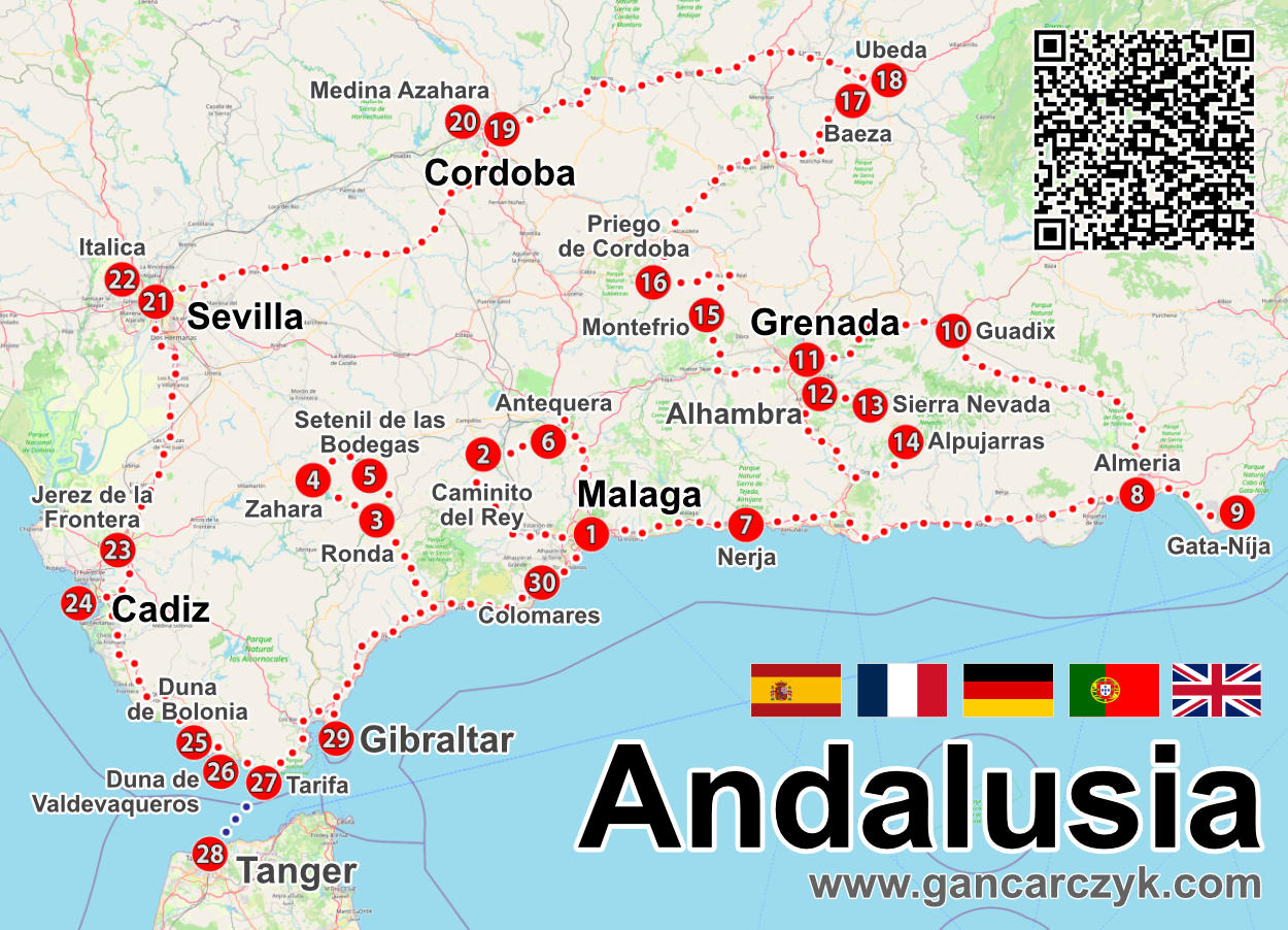
The starting point for starting your planning will, as always, be a special map prepared by me. It will be the main tool of my and your work. Below I am posting a version presenting the location of all the attractions and an approximate, optimal route between them. Of course, the plan and route I have proposed are not the only and best ones. This is a proposal that you may like, but there is nothing to stop you from creating your own plan based on my data. I even encourage you to rebuild and modify my ideas. After all, the point is for each of you to be able to realize your dream vacation idea!
Tip:
If you lose your map, don't worry! You don't have to remember any pages!
Type in Google: Andalusia gancarczyk
I'll show up at the top of search results!
The same applies to other majors!

1. Málaga
2. Caminito del Rey
3. Round
4. Zahara
5. Setenil de las Bodegas
6. Antequera
7. Nerja (Caves: Nerja and Treasure Cave)
8. Almeria
9. Parque Natural del Cabo de Gata-Níja
10. Guadix
11. Grenada
12.Alhambra
13.Sierra Nevada
14. Alpujarras
15. Montefrio
16. Priego de Cordoba
17.Baeza
18. Ubeda
19. Cordoba
20. Medina Azahara
21. Seville
22. Italica
23. Jerez de la Frontera
24. Cadiz
25. Duna de Bologna
26. Valdevaqueros Duna
27. Tarifa
28. Tangier
29.Gibraltar
30. Colomares
First, it's worth spending some time looking at the map and checking the locations of the places you're most interested in. If you click on the map, a higher resolution image will open, showing more details (roads, names of nearby towns, etc.)
The organization of this article will make it easier for you to use the map (even outdoors) and create your own itinerary. Each attraction has a unique number. You'll also find this number (in addition to the maps) in the table of contents at the beginning of the guide and in the chapter headings related to the more detailed descriptions of the attractions. Each attraction I've mentioned has its own description further down in the text, containing more details, interesting facts, and very useful GPS coordinates for important locations and parking lots. Attraction coordinates make it incredibly easy to reach them. Use this data! They're incredibly easy to use. Just click the link next to them, and your phone's navigation will automatically launch and plot a route to your destination (just remember to switch from walking to driving mode, or vice versa).
Some of the attractions that require more detailed discussion, in addition to the brief information in this entry, also have their own articles (e.g. Caminito del Rey, Ronda, Malaga, etc.), dedicated to them, containing much more information and advice. Links to them (if such extended entries exist) can be found later in the guide, in their descriptions. If new descriptions are created, the links to them will be updated by me on an ongoing basis.
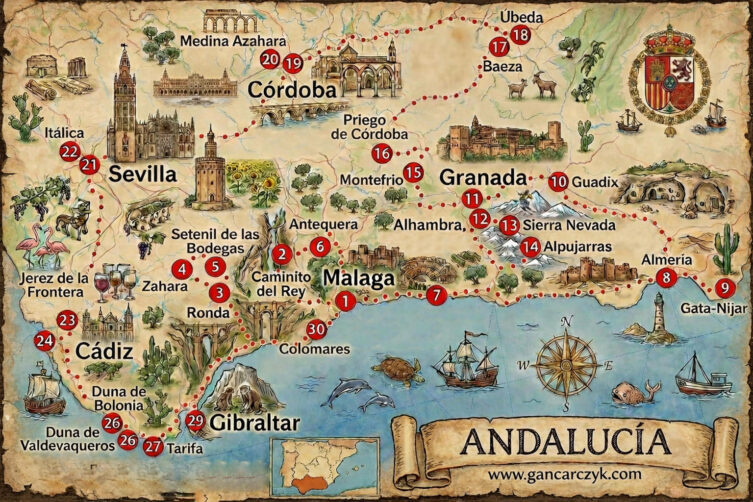
If you enjoy having a map in your hands that perfectly captures the atmosphere of your trip, I've also prepared a high-quality illustrated map of Andalusia. It's an exact replica of the previous map, but has a completely different feel. It works perfectly with this guidebook, and the numbering of attractions is identical, so feel free to use it instead of a traditional map!
I also know that some of you have printed out my regular maps as part of your travel journal. An illustrated map is even better for this purpose. If you're planning to create a souvenir photo book, what better way could there be to illustrate your trip?
If you want to print the map in the best quality or include it in a photo book, download the illustrated map of Apulia in higher resolution – [click]
Andalusia sightseeing plan
I must immediately point out that the plan I have proposed is very intensive. It has been planned for 14 days and does not include even one day for rest. Every day something happens and the days are completely filled. Of course, there are also days in which we will visit the wonderful landscapes of the coast and beaches, but I have not planned a long beach vacation for them. Rather, a moderately short rest with a break to admire nature.
Don't worry if you don't manage to complete your plan. I assumed that most people who wanted to visit wouldn't be able to visit all the points. I know that the question immediately comes to mind: why did I prepare such a plan? The reason is simple and you will soon think that I cleverly came up with it. I assumed that not everyone is interested in the same things. Therefore, if the plan were not so dense, removing one attraction from it would create a hole. For me, removing something that interests you less doesn't bother me at all, because you have several other offers right next to it. So you can safely get rid of what you don't feel like doing and there will still be something to see. In accordance with this principle, I have already written several plans and it turns out that it works really well.
In my guidebook, I assumed that we would start our tour from Malaga. In most cases, this will be the case, as it is the main transport hub for the entire region. However, if you are flying into another city (e.g. Seville), it doesn't really change much. I planned the route as a closed loop, so you can start from any starting point, and in the end you will return to the starting point anyway. This form of plan seemed the most universal and useful to me.
Day 1 – Arrival in Malaga (1) and a short reconnaissance
I spent the first day arriving, checking in, and picking up my rental car. If you arrive in Malaga (1) early and have some free time in the afternoon or evening, take a walk around the city. Malaga sightseeing plan is quite extensive, so if you manage to see a few places on the first day, exploring the city the next day will simply be less intense.
Below I am posting the link to the accommodation I mentioned, which contains the necessary filters. You will find identically prepared links for the other accommodations, but I will not describe or comment on them in detail.
accommodation: Malaga – [show accommodation]
Day 2 – Malaga (1)
I've allotted one day for exploring Malaga. That's very little. Malaga is a large city packed with attractions. Fitting everything into one day will be difficult. However, I won't leave you without help. I've written a separate Malaga itinerary and guide – [click] , where you'll find a ready-made sightseeing plan for one day.
accommodation: Malaga again – [show accommodation]
Day 3 – Caminito del Rey (2) and Antequera (6)
Transit route: Málaga (1) – Caminito del Rey (2) – Antequera (6) – Málaga (1)
Length of the ride: 170 km
Driving time (without breaks and sightseeing time): 3 h
accommodation: Malaga – [show accommodation]

On the third day of your trip, prepare for a real knockout blow. Today's route is a culmination of emotions you'll remember for the rest of your life. We head inland to confront a legend and discover places where nature and human courage have created something truly unique.
We start the day with Caminito del Rey (2). This isn't just a walk, it's a hike along paths clinging to the vertical walls of the Desfiladero de los Gaitanes gorge. Once called "the most dangerous trail in the world," today, after a thorough renovation, it's a safe, yet still vertiginous, adventure. Walking along wooden walkways suspended hundreds of meters above the canyon floor, you feel the power of space. The turquoise waters of the Guadalhorce River below, the rugged rocks overhead, and that moment of crossing the suspension bridge as the wind gently sways the structure—these are moments when you know you'll always relive the memories. I recommend booking an early morning hike, when the sun is just beginning to penetrate the gorge and the temperature is perfect for walking.
Once the adrenaline from the Caminito has subsided, we continue towards Antequera (6). This place offers a completely different kind of delight. Our main destination is El Torcal de Antequera, one of the most spectacular karst landscapes in Europe. Nature has played sculptor here, shaping the limestone rocks into shapes reminiscent of pancakes, towers, and fairytale characters. Walking among these formations feels like walking along the bottom of a prehistoric sea that decided to rise to the surface millions of years ago.
If time permits, Antequera itself invites you to stroll through its historic center. The city is called the "heart of Andalusia," and this feeling is felt in every corner, from the monumental UNESCO dolmens, which remind us of a bygone past, to the white facades of the churches and the Alcazaba fortress towering over the area. The view from the viewpoints of the "Mountain of the Lovers" (Pena de los Enamorados) is the perfect way to end the day.
A day of extremes is behind us. From the thrill of the Caminito del Rey to the soothing peace of the stone labyrinth in Antequera, this route is for those who want to experience the power of nature and witness the incredible scenarios that time and geology can create.
WARNING!!!
The Caminito del Rey (2) is ticketed and tickets are purchased for a specific entry time. The attraction is very popular, so make sure you book your tickets well in advance (at least a few weeks) because you need a ticket for a specific day and time to fit your travel plans.
check : tickets to Caminito del Rey – [click]
Day 4 – Nerja (7) and Almeria (8) and something along the way
Transit route: Malaga (1) – Nerja (7) – Almeria (8)
Length of the ride: 220 km
Driving time (without breaks and sightseeing time): 3 h
accommodation: Almeria – [show accommodation]

Day four sees us bid farewell to bustling Malaga (1) and begin our journey east, where the Costa del Sol landscape slowly gives way to the harsher, almost desert-like wilderness of Almería. Before we reach our destination, however, a day awaits us, suspended between the dark secrets hidden underground and the dazzling blue of the Mediterranean Sea.
Our first stop is almost on the doorstep of Malaga, in Rincón de la Victoria. Here lies the Cueva del Tesoro, or Cave of the Treasure. This is an absolutely unique place – one of only three known marine caves in the world (the other two are located in Asia and Central America). Water has carved out elaborate galleries and chambers in the limestone, which for centuries have concealed the legend of the hidden treasure of five kings of the Almoravid dynasty. Even if you don't find gold, the coolness of the underground and the knowledge that you're standing in a place carved by sea waves millions of years ago are reward enough.
We continue until Nerja (7) looms before our eyes. Despite its popularity, this town has retained the charm of a white Andalusian village. Its heart is the Balcon de Europa (a spectacular vantage point jutting out from a cliff, overlooking the rocky coast and hidden coves below). It's here that coffee tastes best, with your gaze drawn between the horizon and the sheer cliffs.
Right next door are the Cuevas de Nerja, known as the "underground cathedral of Andalusia." The sheer scale of this place is breathtaking. This vast cave system houses the world's largest stalactite (listed in the Guinness Book of Records!), measuring an impressive 32 meters high. Walking beneath the massive vaults, among formations that resemble frozen waterfalls, makes you realize how small humans are compared to the patient work of nature.
We'll spend the second half of the day traveling to Almeria (8). The city welcomes us with a completely different energy. More austere, steeped in Moorish history and the proximity of Europe's only desert. I hope you'll have enough energy for an afternoon wander, because Almeria is at its best in the golden light of sunset, when the walls of the mighty Alcazaba fortress begin to glow against the blue sky.
A day of contrasts awaits us: from the damp, dark corridors of caves, through the sunny terraces of Nerja, to the monumental defensive architecture of Almeria. This route shows that Spain's southern coast is not just about beaches, but above all, fascinating stories hidden deep underground and high on the cliffs.
Day 5 – Cabo de Gata-Níja (9), Gaudix (10)
Transit route: Almeria (8) – Parque Natural del Cabo de Gata-Níja (9) – Gaudix (10) – Granada (11)
Length of the ride: 210 km
Driving time (without breaks and sightseeing time): 3 h
accommodation: Granada – [show accommodation]

Day five is a journey through landscapes that seem to come from another planet. We leave civilization behind to first encounter the stark, volcanic beauty of the coast, and then discover how humans have managed to coexist with the land in the most literal sense of the word for centuries.
We begin with a wander through the Cabo de Gata-Níjar Natural Park (9). It's one of the last truly wild and unspoiled stretches of the Mediterranean coast. Forget the rows of hotels. Here, nature reigns supreme! The region's volcanic past has left behind spectacular black cliffs, basalt formations, and hidden bays with crystal-clear waters. A must-see is Arrecife de las Sirenas (Mermaids' Reef), where jagged rocks rise straight from the turquoise depths, creating a sight worth every minute spent on the road. The wind here smells of salt and herbs, and the silence is broken only by the sound of crashing waves.
Once we've feasted our eyes on the blue, we head inland, towards the Sierra Nevada mountain range. Our destination is Guadix (10), a place that astonishes every traveler. Instead of traditional rooftops, you'll see white chimneys jutting out from the red clay hills. This is the famous Barrio de las Cuevas, a district of houses carved into the rock. However, these are not abandoned ruins, but a living city: some two thousand caves are still inhabited today. The microclimate within them ensures a pleasant temperature year-round (around 18-20°C), a luxury worth its weight in gold in the sweltering Andalusia. Walking among the hills, where the roofs double as sidewalks, is a surreal and unique experience.
We end the day in Granada (11 AM). Although we've planned our main sightseeing for tomorrow, our evening arrival into the city, dominated by the snow-capped peaks of the Sierra Nevada, promises something special. It's the perfect moment for a first stroll through the Albayzín district or for dinner with a view of the Alhambra illuminated in the distance. Granada's atmosphere, where the Orient meets Christian tradition, will set you up perfectly for what the next day will bring.
We've had a journey full of visual shocks. From the volcanic ash of Cabo de Gata, through the subterranean life of Guadix, to the gates of a Moorish paradise. Today proved that Andalusia is a land that never ceases to surprise, even when you think you've seen it all.
Day 6 – Granada (11), Alhambra (12)
Day six is the moment when we forget about the car keys for a moment. Granada is a city best enjoyed on foot, its heart beating to the rhythm of your footsteps on its cobblestone streets. Today, before you lies an absolute jewel in the crown of Spanish monuments, a place that redefines the concept of beauty and architectural precision.
We're starting with the Alhambra (12). This isn't just any castle; it's a massive, UNESCO-listed palace and fortress complex that was the last bastion of the Moors in Europe. Step inside the Nasrid Palaces and you'll feel as if you've stepped straight into the pages of "One Thousand and One Nights." Intricately carved stucco, lace arches, and the famous Court of the Lions blur the lines between stone and fabric. Next door lie the Generalife Gardens, the sultans' summer residence, where the sound of flowing water and the scent of jasmine create an atmosphere of absolute tranquility. Just remember the golden rule: tickets to the Alhambra must be booked well in advance! It's the most popular monument in Spain and shows no mercy to latecomers.
After descending the Alhambra hill, we immerse ourselves in the labyrinthine Albaicín. This is the oldest Arab quarter, also a UNESCO World Heritage Site, and has survived almost unchanged for centuries. Walking here is a challenge for orientation, but also a great pleasure. The white walls of the houses (carmenes), the smell of brewing tea in the teterías, and the sudden glimpses of the fortress towering over the city create an atmosphere that cannot be replicated. Your destination is the Mirador de San Nicolas. There, sitting on a low wall alongside local flamenco musicians, you will witness the most beautiful sunset of your life: the moment when the Alhambra's walls turn from sandy to intense red (hence its name: al-Hamra, meaning "the Red").
An evening in Granada is the perfect time for a tapas tour. The tradition of free snacks with every drink is still going strong in this city. It's the ultimate reward for the thousands of steps you'll take today.
A day full of admiration for the artistry of the old masters is behind us. From the mathematical perfection of the sultans' palaces to the chaotic yet magnetic charm of Arab streets, Granada doesn't demand attention. It simply steals it from the very first second.
The Generalife, located right next to the main palaces of the Alhambra, was the retreat of the kings of Granada. Its name derives from the Arabic Jannat al-Arif, meaning "Garden of the Architect." The gardens' irrigation system is based on ingenious 13th-century engineering, which exploits the elevation difference in the terrain to bring water from the Darro River without the use of pumps.
accommodation: Granada – [show accommodation]
Day 7 – Sierra Nevada (13) and Alpujarras (14)
Transit route: Granada (11) – Sierra Nevada (13) – Alpujarras (14) – Granada (11)
Length of the ride: 210 km
Driving time (without breaks and sightseeing time): 4 h 30 min
accommodation: Granada – [show accommodation]

Day seven is an escape into the clouds. We'll trade the hustle and bustle of the city for crisp, high-altitude air and views that make you feel dwarfed by the power of nature. Today's route, however, is not only an aesthetic feast but also a significant logistical and technical challenge. The roads will twist like serpentines, and your car's engine will feel every change in altitude.
We begin by ascending the highest point of the Sierra Nevada (13). We head towards the Hoya de la Mora point, located at an altitude of approximately 2500 meters above sea level. This is the highest point in Europe accessible by paved road. From here, on a clear day, the panorama can be breathtaking: the rugged, snow-capped peaks of Veleta and Mulhacen (the highest peak on the Iberian Peninsula) seem within reach. However, remember an important rule for this day: if you want to complete your entire plan, treat the mountains as a viewpoint. One longer hike will mean you'll have to leave the Alpujarras for another time. The choice is yours. Sometimes the silence of a ridge is worth more than another stop on your itinerary.
If you decide to continue, we head to the southern slopes of the massif, to the Las Alpujarras region (14). This is a land of white villages suspended over precipices, looking as if time had stopped there during the era of Moorish rule. Villages like Pampaneira, Bubion, and Capileira, nestled in the Poqueira Valley, embody the quintessence of Andalusian idyll. Narrow, steep streets, flat roofs with characteristic chimneys, and colorful carpets (jarapas) hanging from the walls create an inimitable setting. The air here smells of burnt wood and herbs, and the water from the local springs is icy and crystal clear.
I must warn you, however: this will be a very demanding day for the driver . The roads are narrow, winding, and incredibly steep. If you feel like struggling with the steering wheel is taking away from the joy of the journey, give up. There's no obligation to "complete" everything. Sometimes it's better to spend two more hours on a terrace in one of the white villages, gazing at the mountains, than rushing through kilometers of switchbacks.
A day full of altitude and technical challenges lies ahead. From the stark, almost lunar landscapes of the high Sierra Nevada to the cozy, flower-filled terraces of the Alpujarras. This is a route for those who love space and aren't afraid of twists and turns (literally and figuratively).
Las Alpujarras is renowned for its unique Berber architecture, brought by settlers from North Africa. Its flat, clay roofs (launa) and distinctive chimneys are ideally suited to the harsh mountainous conditions. This region was also the last refuge of the Moors after the fall of Granada in 1492.
Day 8 – Montefrio (15), Priego de Cordoba (16), Baeza (17) and Ubeda (18)
Transit route: Granada (11) – Montefrio (15) – Priego de Cordoba (16) – Baeza (17) – Ubeda (18)
Length of the ride: 220 km
Driving time (without breaks and sightseeing time): 3 h 30 min
accommodation: in one of the two towns Bazea – [show accommodation] or Ubeda – [show accommodation]

On the morning of the eighth day, we leave Granada to explore four beautiful Andalusian towns. This will be an intense journey through the olive groves of the provinces of Granada, Córdoba, and Jaén, leading from spectacular viewpoints to Baroque splendor and the mathematical harmony of the Renaissance.
We start in Montefrío (15), which will greet you with a view straight out of a National Geographic magazine cover (the magazine named it one of the 10 most beautiful cities in the world). Towering above the white houses is a massive rocky outcrop, home to the Iglesia de la Villa church, built on the foundations of a former Arab fortress. It's worth climbing to the Mirador National Geographic viewpoint to see how the town blends seamlessly with the dramatic rock formations. In the center, notice the Iglesia de la Encarnacion, a circular church unique in Spain, inspired by the Roman Pantheon.
Next, we head to Priego de Córdoba (16), known as the "capital of the Baroque." This city of water and white flowers is particularly impressive, especially the monumental Fuente del Rey (King's Fountain) with its 139 fountains and the labyrinth of narrow streets in the oldest district, Barrio de la Villa. The walk ends at the Balcon del Adarve, a natural observation deck suspended over a cliff, overlooking a sea of olive trees.
The second half of the day is dedicated to two cities jointly listed on the UNESCO World Heritage List: Baeza and Úbeda. First, we visit Baeza (17), which captivates with its intimate, almost university-like atmosphere. Here, in the Plaza de Santa María, stands the Renaissance cathedral, and right next door are the former university and the fairytale Palacio de Jabalquinto, with its façade decorated in the Isabelline style.
We end the day in neighboring Úbeda (18), a true Renaissance manifestation. Its heart is Plaza Vazquez de Molina, considered one of the most beautiful squares in Europe. The Sacra Capilla del Salvador, with its stunning façade, and the noble palaces create a setting that transports us straight to the 16th century, when the city was awash with gold imported from the New World.
A day of great contrasts and architectural grandeur lies ahead. From the volcanic rocks of Montefrío, through the roar of the fountains in Priego, to the stately Renaissance of Úbeda. This is a route through the essence of inland Andalusia… a land of sun, olive oil, and history carved in pale stone.
Practical tip : I recommend staying overnight in Úbeda. Evening strolls through its illuminated squares have a magic you won't experience during the day. The average price for accommodation at hotels like Puerta de La Luna or Hotel RL Ciudad de Úbeda hovers around 200 PLN per night.
Day 9 – Cordoba (19), Medina Azahara (20)
Transit route: Ubeda (18) – Cordoba (19) – Medina Azahara (20)
Length of the ride: 150 km
Driving time (without breaks and sightseeing time): 2 h
accommodation: Cordoba – [show accommodation]

Day nine takes us into the heart of ancient Al-Andalus. Córdoba, once the most important center of science and culture in Europe, is now the only city in the world with four UNESCO World Heritage Sites. I recommend visiting it twice. First, during the day, discovering its details in full sunlight, and then after dark, allowing yourself to be captivated by the magic of its nighttime illuminations.
We begin our day a few kilometers outside the center, in Medina Azahara (20). This "Shining City," built in the 10th century by Caliph Abd ar-Rahman III, was intended to be a symbol of power and luxury. Although today it is mostly picturesque ruins, a stroll through the terraced gardens and restored audience halls allows us to imagine the grandeur with which this complex was built. It's the perfect introduction to understanding the region's history before we even enter the maze of city streets.
Back in the center, it's time for the highlight: La Mezquita. This absolutely stunning Grand Cathedral-Mosque captivates everyone who walks in. A "forest of columns" strung together by distinctive red-and-white arches stretches almost endlessly, creating a mesmerizing pattern. The sight of a Christian cathedral "growing" in the midst of a Muslim mosque is an architectural paradox unparalleled anywhere in the world. It's a place where time and religions have converged, creating something unique.
After an intense sightseeing tour, it's time for a moment of respite, before returning to the streets in the evening. Córdoba transforms after dark. Artificial lighting brings out details that are invisible during the day, and a walk across the illuminated Roman Bridge (Puente Romano) with a view of the illuminated Mezquita is one of those moments that lingers in the mind's eye for a very long time. The narrow streets of the Judería district become even more mysterious and atmospheric.
Day 10 – Seville (21) and Italica (22)
Transit route: Cordoba (19) – Italica (22) – Seville (21)
Length of the ride: 170 km
Driving time (without breaks and sightseeing time): 2 h
accommodation: Seville – [show accommodation]

I understand your pain! Allocating only one day to Seville is practically sacrilege. Seville is a time-saver; one look at its squares is enough to make you want to stay a week. However, the plan is ambitious, and today, though intense, will be the epitome of Andalusian splendor: from Roman ruins to Gothic and Moorish masterpieces.
We begin the day just outside the city, in Italica (22). This is where Rome's power on the peninsula was born (it was the birthplace of Emperors Trajan and Hadrian). The most impressive feature is the monumental amphitheater, which could seat 25 spectators. Strolling among the perfectly preserved mosaics and ancient streets, you'll get a foretaste of the grandeur that awaits you in the regional capital itself. "Game of Thrones" fans will surely recognize the Dragon's Den here, but even without the film's context, Italica is a first-rate history lesson.
From the Roman ruins, we drive straight into the bustling city of Seville (21). To make the most of this day, we focus on the "Golden Triangle." We begin with the Cathedral of Our Lady, the largest Gothic church in the world. Its scale is stunning, and climbing the Giralda tower (former minaret) rewards the effort with the best panoramic view of the city. Right next door awaits the Real Alcazar, a royal palace, an absolute triumph of the Mudejar style . Lace decorations, hidden patios, and gardens where water flows in the shade of palm trees will make you forget about the rush for a moment.
At the end of the day, we head towards Plaza de Espana. Despite being built in 1929, this place looks like something straight out of a fairytale about ancient Spain. The semicircular square, with its bridges over the canal and ceramic mosaics representing the Spanish provinces, is a visual treat. Spend an evening in the labyrinthine Santa Cruz district (the former Jewish quarter), where the scent of oranges mingles with the sounds of flamenco emanating from hidden bars.
A day full of logistical and emotional challenges lies behind us. From the Roman amphitheater, through the majesty of the cathedral, to the romance of Santa Cruz. Seville in a day is a sprint, but I promise that after such a sprint, you'll fall head over heels in love with this city and will already be planning your return.
Day 11 – Jerez de la Frontera (23), Cadiz (24), Duna de Bologna (25), Duna De Valdevaqueros (26), Tarifa (27)
Transit route: Seville (21) – Jerez de la Frontera (23), Cadiz (24), Duna de Bologna (25), Duna De Valdevaqueros (26), Tarifa (27)
Length of the ride: 250 km
Driving time (without breaks and sightseeing time): 3 h 30 min
accommodation: Tarifa – [show accommodation]

On day eleven, there's no doubt in anyone's mind that the pace of our journey isn't slowing down for a moment. Today's route takes us from the aristocratic tranquility of wine country, through the oldest city in Western Europe, to the wild, sandy coast, where the wind from Africa becomes almost tangible.
We begin in Jerez de la Frontera (23), a city redolent of oak barrels and history. It's the world capital of sherry (Vino de Jerez). A visit here might be brief, but if you're persuaded to sample it at one of the legendary bodegas like Tio Pepe or Domecq, time can speed up dangerously. Jerez isn't just about wine, though; it's also about the elegance of Andalusian horses and the deep, authentic sound of flamenco that echoes through the palm-fringed squares.
Next, we head towards the ocean, to Cadiz (24). This city literally "floats" on the waves of the Atlantic, connected to the mainland only by a narrow isthmus. Cadiz has something of the magic of Havana. The dilapidated facades of the buildings, the golden dome of the cathedral, and the promenades, crashing with mighty waves, create a melancholic yet incredibly joyful atmosphere. A stroll through the narrow streets of the El Populo district will allow you to feel the weight of this port's three thousand-year history.
In the afternoon, the landscape changes dramatically. We enter regions where sand and wind rule. Duna de Bolonia (25) is a natural phenomenon. The gigantic, shifting dune seems to devour the nearby pine forest. Right at its foot lie the ruins of the Roman city of Baelo Claudia, creating a surreal sight: ancient columns set against the blue ocean and white sand. A little further on, Duna de Valdevaqueros (26) greets us with the sight of hundreds of colorful kites. This is a mecca for kitesurfers, where the sandy-desert landscape reminds us that we are very close to another continent.
We end the day in Tarifa (27). It's the southernmost point of continental Europe, where the Mediterranean meets the Atlantic. Tarifa has a unique, laid-back feel, a surf town nestled within medieval walls. Overnight stays here are crucial. It's from here, from a port nestled between two bodies of water, that we'll set off tomorrow on a journey that will take us to Africa.
A day full of space and sea breezes is behind us. From the elegant bodegas of Jerez, through the bustling city of Cádiz, to the wild sands of Bologna. An evening in Tarifa, with a view of the twinkling lights of Tangier across the strait, is the perfect prelude to the biggest adventure of the trip.
Sherry (Vino de Jerez) is a unique wine thanks to the solera system (an aging process that involves blending younger vintages with older ones in pyramids of barrels). This allows the wine to maintain its consistent character for decades. Remember, true Jerez sherry comes in many varieties: from the very dry and light Fino to the dark and sweet Pedro Ximenez.
Day 12 – Tangier (28) … or we’re sailing to Africa!
This was definitely something no one expected! For the twelfth day of your Andalusian trip, I suggest a cruise to Africa, specifically Morocco (be sure to bring your passport!). Tarifa has regular connections with Tangier (28), and the one-way trip takes less than an hour. In one day, you can sail, explore this mythical city on foot, and return before evening. If it's possible, and we're so close, why not ? Especially since you can buy boat tickets online – [click] , and on the other side, you don't need a car.
After disembarking at the port of Tangier Ville, as I mentioned, a car becomes unnecessary. The true soul of the city lies hidden in the maze of streets, through which no car can pass anyway. Your African adventure begins in the Medina, the old walled city. Here, the intense aromas of spices, freshly baked bread, and the bustle of the local souks (markets) assault your senses. Strolling through the narrow passages, you'll reach the Petit Socco, a charming square that was once a center of international espionage and literary gossip, and today is the perfect place for your first glass of traditional mint tea.
Heading uphill, you'll reach the Kasbah, the highest point of the old town. It's here, inside the former citadel, that the Kasbah Museum is located, housed in the former sultan's palace, Dar el-Makhzen. Even if you don't plan on spending much time exploring the exhibition, it's worth visiting the square in front of the museum for the panoramic view alone. The view from the Kasbah walls of the Strait of Gibraltar, where the blue water meets the outline of the Spanish coast, is one of those images that best defines Tangier as the "gateway to two continents."
Another must-see is the Grand Socco, a massive square that connects the old Medina with the modern part of the city (Ville Nouvelle). This is where the heart of Tangier beats, and right next door you can relax in the Mendoubia Gardens, home to giant fig trees and ancient trees. If you have time and energy, stroll along the Corniche seaside promenade to feel the ocean breeze before heading back to the port for your return ferry.
Before evening we return to Tarifa for another overnight stay, with the sights, sounds and tastes of a completely different continent in our minds.
A day has passed that proved that borders are just lines on a map. From breakfast in Europe, to Moroccan tagine for lunch, to dinner overlooking the African coast from Tarifa. Tangier is a legendary city that can completely change your perspective on the world in just a few hours.
For many years (1923–1956), Tangier enjoyed the status of an "international zone," jointly administered by several countries. It was during this time that the city became a mecca for artists, writers (such as Paul Bowles and William S. Burroughs), and intelligence agents, giving it a unique, cosmopolitan, and somewhat mysterious atmosphere that can still be felt today.
It is worth buying ferry tickets in advance online (e.g. through Direct Ferries ) to avoid queues at the port and to be sure of a seat at the selected time.
accommodation: Tarifa – [show accommodation]
Day 13 – Gibraltar (29), Ronda (3)
Transit route: Tarifa (27) – Gibraltar (29) – Ronda (3)
Length of the ride: 170 km
Driving time (without breaks and sightseeing time): 3 h
accommodation: Ronda – [show accommodation]

After yesterday's visit to Morocco, today it's time for another flag change as we head to Great Britain. Our destination is Gibraltar (29), a British Overseas Territory. So don't hide your passport after your African adventure, because you'll need it today when crossing the Spanish-British border. Gibraltar is a strange place, where Spanish temperament blends with British phlegm, and red telephone boxes stand in the shadow of a massive rock.
Entering Gibraltar is an experience in itself. The route leads directly across the airport runway, which intersects the only route into the city. The heart of the territory is the Rock of Gibraltar. You can ascend by cable car, reaching a height of over 400 meters in just a few minutes. It's here that you'll encounter the peninsula's most famous inhabitants: the Barbary Macaques . They're the only wild population of monkeys in Europe. They're photogenic, but beware: they're professional thieves of snacks, sunglasses, handbags, and cameras!
Inside the Rock lies the stunning St. Michael's Cave, which, thanks to its modern lighting and sound system, resembles the interior of a fantastic cathedral. History buffs must visit the Great Siege Tunnels (a maze of tunnels carved in the 18th century). To the south lies Europa Point, from where, on a clear day, Africa seems within reach. Finally, stroll down Main Street for some classic fish and chips and experience the atmosphere of London's High Street in the heart of the Mediterranean.
After our British adventure, we're leaving the coast and heading inland to Ronda (3). It's crucial we arrive before dusk. Ronda, after sunset, illuminated by the warm glow of streetlights, looks like a scene from a movie. The main destination is the Puente Nuevo (a monumental, nearly 100-meter-long bridge), which connects the two halves of the city, separated by the El Tajo gorge. An overnight stay in Ronda will allow you to experience the magic of this place without the crowds of day-trippers and ensure you'll be the first on the trail tomorrow morning.
The Gibraltar Barbary Macaques are surrounded by legend, which states that as long as they remain on the rock, Gibraltar will remain in British hands. They are treated with the utmost respect here. During World War II, when their population plummeted, Winston Churchill himself ordered new specimens brought in from North Africa to fulfill the tradition.
Day 14 – Ronda (3), Zahara (4) and Setenil de las Bodegas (5)
Transit route: Zahara (4) – Setenil de las Bodegas (5) – Ronda (3)
Length of the ride: 90 km
Driving time (without breaks and sightseeing time): 2 h
accommodation: Ronda – [show accommodation]

We're slowly bidding farewell to Andalusia, but we're doing it in truly royal style. Today is the epitome of the famous Pueblos Blancos (White Villages), where each new location seems to be vying with the last for the title of most surreal. This is a finale of the highest order! Prepare for architecture that defies gravity and logic.
We start the morning in Ronda (3). Since you've spent the night here, you have the luxury of seeing the Puente Nuevo in the morning sun before the coaches from the coast arrive. This 18th-century bridge is an engineering masterpiece, spanning the two halves of the city over the 100-meter-high El Tajo gorge. Walking down to the viewpoints in the valley, you'll appreciate just how monumental this structure is. Ronda isn't just a bridge, though; it's also home to one of Spain's oldest and most prestigious bullfighting arenas (Plaza de Toros) and a labyrinth of gardens and palaces that Hemingway and Rilke praised as the most romantic place in the world.
The next stop is Setenil de las Bodegas (5). A town you have to see to believe. Here, people didn't build their houses on the rocks, but beneath them. A stroll through the streets of Calle Cuevas del Sol and Calle Cuevas de la Sombra is an almost claustrophobic, yet fascinating, experience. Massive basalt overhangs serve as natural roofs for houses, bars, and shops. This is a place where geology literally peers in, and coffee sipped in the shade of a rock several hundred tons tall tastes completely different than anywhere else.
For dessert, we leave Zahara de la Sierra (4). The view of this town from afar is breathtaking: white houses climb a steep hill, atop which the ruins of a Moorish castle proudly tower, and at its foot the shimmering turquoise waters of the Embalse de Zahara-el Gastor reservoir. This is the quintessence of the Andalusian landscape. It's worth gathering your last remaining strength and climbing all the way to the castle tower. The panoramic view from there is the best way to sum up the entire trip.
Day 15 – Colomares Castle (30) and return to Malaga (1)
Transit route: Ronda (3) – Colomares Castle (30) – Malaga (1)
Length of the ride: 125 km
Driving time (without breaks and sightseeing time): 2 h

Day fifteen is the time when we're slowly closing our Andalusian loop. While your mind is probably already on packing your bags and scrolling through hundreds of photos on your phone, we have one more, incredibly photogenic surprise for you. This morning is your last chance to experience the magic of the local architecture before we return the car and head back home.
On our way to Malaga Airport, we stop in Benalmádena to visit Colomares Castle (30). Although from a distance it looks like an ancient, fairytale fortress, blending Gothic, Renaissance, and Moorish styles, it is actually a monumental monument built in the late 20th century. It pays tribute to Christopher Columbus and his discovery of the New World. Every detail of this "castle," from the carved ships to the intricate turrets, tells a piece of the story of the voyage to the Americas. Strolling its terraces, it's worth noting the world's smallest church (listed in the Guinness Book of Records!), located inside one of the towers. This place is the true highlight of our trip, demonstrating that in Andalusia, history and fantasy always go hand in hand.
From Benalmadena, we head straight to Malaga Airport. This is where our great adventure ends. We return the car that, for the past two weeks, has braved the mountain serpentines of the Sierra Nevada, the desert wastelands of Almeria, and the narrow streets of whitewashed towns. It's time for check-in, a last coffee in Spain, and the return home to start planning our next trips.
Fifteen intense days of living the rhythm of southern Spain are behind us. We've traveled hundreds of kilometers, visited two continents, touched the history of three religions, and seen landscapes that forever changed our definition of "beauty." Andalusia bid us farewell with sunshine and architectural splendor.
I think it's safe to say don't say goodbye! It would probably be: see you Andalusia!
If you run out of ideas, I remind you that you can always use the list of my prepared guides – [click]
Description of attractions on the trip route
1. Málaga

Malaga, due to its location, has definitely dominated the tourist traffic in the region. It is from Malaga that the adventure with Andalusia usually begins. My sightseeing plan also begins here.
The city is mainly associated with the sweet wine of the same name, relaxation on sunny beaches and (thanks to Pablo Picasso, who was born in Malaga) with omnipresent art. By far the most important source of income for Malaga is currently tourism and it is immediately obvious that they take care of tourists here. Parks, promenades, alleys, excellent food, vast beaches and even free museums.
Malaga has so much to offer that it required a separate sightseeing plan. So I'll just leave it at this point link to Malaga guide – [click], thanks to which you will get to know the entire city well.
filter link: Malaga accommodation – [click]
You'll likely be staying overnight in Malaga and will park your car somewhere near your accommodation. However, if you don't plan to stay overnight in Malaga and need a convenient and well-located parking lot while exploring the city, I've provided the coordinates below. It's a 24-hour parking lot beneath the bullring (Plaza de toros de La Malagueta). Bus number 35 stops right next to it, taking you to the top of the hill where my Malaga sightseeing itinerary begins – [click] . The parking lot is accessed via a dedicated road, closed to regular traffic and intended solely for access. The coordinates below indicate the beginning of this road, near a small roundabout.
Malaga - Cervantes car park in the city center (underground, paid), GPS coordinates:
36°43’15.1″N 4°24’42.6″W
36.720863, -4.411835 - click and route
2. Caminito del Rey

This spectacular, incredibly scenic trail, which leads along footbridges suspended on the vertical, rocky slopes of the ravines, will leave you with an unforgettable experience. It's hard to find anything more exciting or beautiful. A detailed description of the trail and plenty of specifics on how to organize your own tour can be found in a separate post about the Caminito del Rey – [click]
Caminito del Rey is, of course, very popular, even crowded, and the number of tickets is limited. Tickets are sold for specific entry times.
check: availability of tickets to Caminito del Rey – [click]
check: organized trips to Caminito del Rey – [click]
There are three different parking lots on Caminito del Rey, each quite far apart. Below are the coordinates for all three, but before you decide which one to go to, read the description of the Caminito del Rey tour – [click] – it will help you make the right choice.
filter link: accommodation in El Chorro near Caminito del Rey – [click]
Parking lot P1 and bus stop (Ardales), GPS coordinates:
36°55’43.9″N 4°48’06.4″W
36.928868, -4.801772 - click and route
Parking lot P2 and BUS stop (El Chorro), GPS coordinates:
36°54’24.4″N 4°45’33.1″W
36.906777, -4.759200 - click and route
P3 parking lot and BUS stop (Visitors Reception Center), GPS coordinates:
36°54’51.6″N 4°48’27.2″W
36.914324, -4.807561 - click and route
3. Round

Just take a look at a few photos to want to see this place live.
The views are simply breathtaking, but some say they are mind-blowing 🙂 Whatever! It is definitely one of those places that you should not miss during your trip to Andalusia.
For those who are more inclined to the version that the views are breathtaking, I suggest buying knee pads, because in the next few days they will be landing on their knees many more times 🙂
For now, however, let's get back to exploring Ronda. I've also written a separate guide for that, so for more details, check out this post: Ronda: sightseeing plan – [click]. In the Ronda sightseeing plan you will find a sightseeing map with marked parking lots, the coordinates of which are given below.
filter link: Ronda accommodation – [click]
Roundabouts: Parking 1 - Plaza del Socorro
36°44’36.0″N 5°09’57.2″W lub
36.743325, -5.165889 - click and route
Roundabouts: Parking 2 - Calle Carlos Cobo Gómez
36°44’38.9″N 5°10’04.0″W lub
36.744132, -5.167770 - click and route
Roundabouts: Parking 3 - Av. The poet Rilke
36°44’42.2″N 5°10’05.2″W lub
36.745056, -5.168099 - click and route
4. Zahara

Zahara de la Sierra is one of the most picturesque "white towns" (so-called Pueblos Blancos), typical of Andalusia.
What are Pueblos Blancos? In short… they are picturesque, small towns in southern Spain (mainly in the Andalusia region, in the Sierra de Grazalema, Sierra Nevada and other mountain ranges). They are characterized by white limestone facades of houses that reflect sunlight and help keep them cool in the hot, Mediterranean climate.
A total of 19 towns have been distinguished by this designation, but tourists following in their footsteps are constantly adding more to the list. For those interested, all 19 towns form the so-called Trail of the White Towns and some people visit Andalusia by traversing it along this route. If you are interested in this idea, here is a full list of towns that are part of the trail (it will help you delve deeper into the subject): Alcalá del Valle, Algar, Algodonales, Arcos de la Frontera, Benaocaz, Bornos, El Bosque, El Gastor, Espera, Grazalema, Olvera, Prado del Rey, Puerto Serrano, Setenil de las Bodegas, Torre Alháquime, Ubrique, Villaluenga del Rosario, Villamartín and Zahara de la Sierra.
Returning to Zahara, it is worth knowing that the history of the town dates back to Phoenician and Roman times, but its importance increased greatly when it became a defensive fortress on the border between the Christian and Muslim kingdoms during the Reconquista (it was conquered by the Christians in 1407, but in 1481 the Moors took control of the city again, which began the final phase of the Reconquista).
During your visit, it is worth visiting the castle (Castillo de Zahara) with its observation tower (Torre del Homenaje) offering spectacular views of the town, lake and surrounding mountains, and strolling through the old centre, which consists of just a few streets. The walk to the castle is steep and quite tiring.
The closest to the path to the castle is a small parking lot, the coordinates of which are given below (this is also the starting point of the path to the castle). You can also park in the second, larger parking lot on the other side of the town (the distances are small). Then we first visit the central square with the viewpoint, and then go to the starting point of the sewage to the castle at the first parking lot.
filter link: Zahara accommodation – [click]
The first parking lot and starting point of the path to the castle, GPS coordinates:
36°50’27.4″N 5°23’20.4″W
36.840949, -5.388985 - click and route
Second (larger) parking lot in Zahara, GPS coordinate:
36°50’25.6″N 5°23’34.5″W
36.840454, -5.392922 - click and route
Zahara Central Square and Viewpoint, GPS coordinates:
36°50’26.2″N 5°23’26.0″W
36.840611, -5.390556 - click and route
5. Setenil de las Bodegas

An attentive reader will have noticed right away that Setenil de las Bodegas is a town that can also be found on the Trail of White Towns. This time, however, the white walls and narrow streets are just an addition to the incredible scenery created by houses squeezed between giant boulders and rock overhangs. It is hard to describe. You have to see it, and at the same time feel the emotions that accompany everyone in this unusual scenery.
Below, of course, I've included the coordinates for the parking lot and probably the two craziest viewpoints you need to head for. Then, just wander around the town and you'll definitely find more photogenic spots.
filter link: Setenil de las Bodegas accommodation – [click]
Main car park near the town (Los Canos Parking), GPS coordinates:
36°51’49.7″N 5°10’59.1″W
36.863798, -5.183074 - click and route
Landmark in one of the most spectacular places (“Cuevas del Sol” street), GPS coordinates:
36°51’44.3″N 5°10’43.4″W
36.862307, -5.178713 - click and route
Second landmark (“Cuevas de la Sombra” street on the other side of the river), GPS coordinates:
36°51’43.2″N 5°10’45.4″W
36.861994, -5.179283 - click and route
6. Antequera

The name Antequera in my guidebook is actually the UNESCO-listed Dolmens Area of Antequera. It consists of several sites, so after visiting the Caminito del Rey (which is how it is planned in my guidebook), you probably won't be able to see everything. It all depends on how much time and energy you have. There are three dolmens and two mountain nature parks to see here. None of these places require long or demanding walks. However, there are walking trails of various lengths available (especially in El Torcal) and if someone feels like taking a longer walk, this option is also available.
As a reminder, I will just add that dolmens are prehistoric megalithic tombs made (to put it simply) of two huge boulders dug vertically into the ground and covered with a third flat boulder.
filter link: Antequera accommodation – [click]
WARNING!
The dolmens and El Trocal can be easily reached from Malaga, even without a car. Local offices organize sightseeing trips. The offer of organized trips and prices can be found in the link below.
check: trips to Antequera Dolmens Site – [click]
Curiosity:
The dolmens in Antequera are very peculiar and therefore extremely interesting. They are characterized by an unusual orientation towards the directions of the world. Only one of them (Dolmen Viera) is situated in a typical way (like almost all dolmens around the Mediterranean Sea), so that at dawn on the summer solstice, sunlight directly enters and illuminates the interior of the dolmen chamber. The other two dolmens face completely different directions.
The Menga Dolmen points to a nearby peak called Pena de los Enamorados, whose shape resembles a human face. Inside the mountain, a cave (Abrigo de Matacabras) covered with prehistoric paintings was discovered.
The Tholos Dolmen in El Romeral is oriented so that in terrestrial orientation it points to the El Torcal Mountains and the Bull Cave located within them, and in astronomical orientation it points to the midday sun at the time of the winter solstice.
– Dolmen Menga (Dolmen de Menga)


photo: Pedro J Pacheco on the rules CC BY-SA 4.0
It is one of the largest known ancient megalithic structures in Europe. Its creation is estimated at 3700 BC. It was made of 32 megaliths, the largest of which weighs about 200 tons. It is 27,5 m long, 6 m wide and 3,5 m high.
After the dolmen was discovered and excavated in the 19th century, the skeletons of several hundred bodies were found inside.
Remembering the unusual orientation of the dolmen, when visiting it, stop in the corridor leading inside and look towards its outlet. In front of you (during favorable weather) you should see Mount Pena de los Enamorados, to which the dolmen points.
Parking at the Menga dolmen and Viera dolmen, GPS coordinates:
37°01’25.3″N 4°32’49.0″W
37.023695, -4.546940 - click and route
– Dolmen Viera (Dolmen de Viera)

photo: Grez on the rules CC BY-SA 3.0
It is located only 70 meters from the Menga dolmen, and its name comes from the discoverers (brothers Antonio and Jose Viera). It is assumed that it is younger than the Menga dolmen and was built between 3510 and 3020 BC. It takes the form of a long corridor ending with a rectangular room, slightly larger than the corridor.
It has a typical (like virtually all places located near the Mediterranean Sea) location relative to the cardinal directions. At dawn on the summer solstice, sunlight enters and directly illuminates the interior of the dolmen chamber.
Parking at the Menga dolmen and Viera dolmen, GPS coordinates:
37°01’25.3″N 4°32’49.0″W
37.023695, -4.546940 - click and route
– Dolmen Tholos de El Romeral

It is approximately 2,5 km away from the two dolmens described above, and at the same time the youngest of them. Its construction is estimated at 1800 BC. At first glance, it looks different from the Menga and Viera dolmens. Its side walls were made of small stones, and large megalithic slabs were used to build the ceiling. The long corridor leading inside ends in two round chambers resembling beehives. Only the first, larger chamber (approximately 4,2 meters in diameter) is available to visitors. The smaller chamber has a diameter of about 2 meters and its floor is lined with stone slabs.
Parking at the Tholos de El Romeral dolmen, GPS coordinates:
37°02’01.8″N 4°32’06.1″W
37.033827, -4.535017 - click and route
– La Peña de los Enamorados Mountain

photo: Julia K on principles CC BY-SA 3.0
A very characteristic mountain that, seen from the city of Antequera, forms the shape of a human face. For this reason, it is often called Montana del Indio (Indian mountain), due to the fact that the shape of the face has distinct Indian features.
There are many typical legends associated with the mountain, which I will not mention, because none of them contains anything that we have not heard before. Much more interesting is the Abrigo de Matacabras cave, located inside the mountain (not open to the public), decorated on its walls with prehistoric paintings. A group of scientists from the University of Seville recently published an analysis based on high-resolution photos of the paintings covering the interior of the cave, confirming the connection of the mountain and the cave with the Menga dolmen pointing to them.
Landmark, which you need to follow when coming from Antequera, GPS coordinates:
37°03’11.5″N 4°30’00.1″W
37.053187, -4.500022 - click and route
-The Torcal of Antequera


The El Torcal de Antequera Nature Reserve, set in the Sierra del Torcal mountain range, is located about 30 minutes drive (18 km) south of Antequera. If you are travelling towards Antequera from Malaga (or vice versa), it is right on the road.
The most important point of the reserve is... the tourist parking lot, where two scenic trails begin. The paths are 1,5 km and 2,7 km long, partially overlapping and are color-coded. Depending on your preferences, weather and willingness, you can go to one of them. If someone does not feel like taking longer walks, it is enough to walk a short, initial part of the trail, where we are accompanied by beautiful views from the very beginning.
The trail leads along an uneven dirt and rocky path. The most unfavorable conditions for walking occur here... in summer!!! This is due to the extremely high temperatures that often occur here, and the tendency for additional heat to accumulate between the rocks, which is exactly where the walking path runs.
The parking lot where the trails through El Torcal begin, GPS coordinates:
36°57’10.3″N 4°32’40.3″W
36.952860, -4.544517 - click and route
Map of the yellow trail (longer) coming from the website Junta de Andalucia
download: map of the trail in El Torcal de Antequera – [click]
7. Nerja (Caves: Nerja and Treasure Cave)

As in the previous point in the description of Antequera, I have hidden more than one attraction under the name Nerja. In addition to Nerja, it will be the Treasure Cave located on the way (close to Malaga) and the Nerja Cave located outside the town. The caves are worth seeing and if you have the opportunity, I recommend seeing both. The order of places visited after leaving Malaga will be as follows:
– Treasure Cave (Cueva del Tesoro)
– Nerja (viewpoint and town)
– Nerja Cave (in the town of Maro)
Treasure Cave
Located in the town of Rincón de la Victoria, Cueva del Tesoro is one of the few sea caves in the world open to the public. It was created by the erosion of limestone rocks by seawater and contains a variety of rock formations, and the interior of the cave consists of several chambers and corridors with unique shapes.
Parking at the Treasure Cave, GPS coordinates:
36°43’10.2″N 4°17’49.9″W
36.719512, -4.297206 – click and route
The town of Nerja
The most important point of the town is the Balcon de Europa viewpoint, located on a cliff, with an amazing view of the coast. I won't even try to describe the scenery, I'm doomed to failure. Just come and see. It's worth it.
The town itself has a typical Andalusian character: narrow streets among houses with whitewashed walls. As it is a popular tourist town, next to which there are several nice beaches (such as Playa de Burriana, Playa de Calahonda or Playa de Maro), you will find quite a large gastronomic base here.
It is best to leave your car at the large parking lot near the beaches and then walk a short distance (about 400m) to the Balcon de Europa viewpoint.
filter link: Nerja accommodation – [click]
Large parking lot on the beaches of Nerja, GPS coordinates:
36°44’49.5″N 3°52’28.7″W
36.747080, -3.874631 - click and route
Balcon de Europa Viewpoint, GPS coordinates:
36°44’39.5″N 3°52’31.2″W
36.744300, -3.875336 - click and route
Nerja Cave (Cuevas de Nerja)
I should actually write Nerja Caves, because it is actually a network of huge caves, filled with incredible stalactites and stalagmites. Prehistoric cave paintings have been found in the caves, and one of the cave halls (Sala de la Cascada) is used to organize concerts.
The caves were discovered by accident in 1959 by a group of boys looking for bats and quickly became one of the most important archaeological and geological attractions in Spain. Cuevas de Nerja is about 5 km long, but only part of the caves is accessible to tourists (the tourist route is about 1 km long and is well-lit and adapted for visitors). It is cool inside (about 19°C), so it is worth taking a light coat.
Car park at the Nerja Caves, GPS coordinates:
36°45’41.0″N 3°50’47.5″W
36.761391, -3.846518 - click and route
8. Almeria

The most important place to visit in Almeria is definitely the Alcazaba, a walled Arab defensive fortress that is said to be even larger than the most famous Alcazaba in Granada. It was built in the 10th century by Caliph Abd ar-Rahman III and, as befits a solid fortress, played a key role in the city's defense. Its strategic position on a hill offers spectacular views of Almeria and the Mediterranean Sea.
filter link: Almeria accommodation – [click]
Curiosity:
The Alcazaba in Almeria has three separate defensive walls: two date back to Arab times, and the third was built after the city was captured by the Christians in 1489. When it was built, the fortress was able to hold the entire population of the city during a siege. It has recently been used as a filming location for numerous films, including Game of Thrones and Conan the Barbarian, starring Arnold Schwarzenegger.
In addition to the Alcazaba, the Cathedral (Catedral de la Encarnación de Almería) and the Vieja Square are also worth seeing. If you want to spend more time in Almeria, you can also see the underground tunnels (Refugios de la Guerra Civil) from the Spanish Civil War.
Below are the coordinates of the most conveniently located multi-storey car park in the city centre, which is very close to all the attractions. Leaving the car park, it is best to visit the attractions (if you want to see them all) in the following order: car park – cathedral – Plaza Vieja – Alcazaba – optional: underground shelters – car park.
Almeria Cathedral, GPS coordinates:
36°50’18.2″N 2°28’02.4″W
36.838375, -2.467340 - click and route
Old Square, GPS coordinates:
36°50’25.1″N 2°28’02.4″W
36.840297, -2.467324 - click and route
Entrance to the Alcazaba de Almería, GPS coordinates:
36°50’24.2″N 2°28’12.9″W
36.840049, -2.470242 - click and route
Refugios de la Guerra Civil war shelters, GPS coordinates:
36°50’29.7″N 2°27’52.9″W
36.841586, -2.464703 - click and route
Parking garage Plaza San Pedro in the center of Almeria, GPS coordinates:
36°50’23.4″N 2°27’54.1″W
36.839818, -2.465027 - click and route
9. Parque Natural del Cabo de Gata-Níja
The first half of the day will be full of beautiful views of the picturesque coastline and beaches located within the Cabo de Gata-Níja Natural Park. The terrain is so beautiful and diverse that you will probably find your favorite spot here. As you drive through this area, you will probably stop many times outside the points I have indicated, and that is exactly how it should be. It is impossible to point out all the points of interest in this area. There are simply too many of them. So I will only point out the main points of the drive, and you can keep your eyes open and enjoy the scenery along the way.
Viewpoint: Mirador del Arrecife de las Sirenas, GPS coordinates:
36°43’19.7″N 2°11’30.9″W
36.722138, -2.191920 - click and route
At this viewpoint you can try to go further towards the coast and explore the coast among the rocks on foot. However, do not do this during high tide and when the wave is clearly visible. The coastal waves can be very dangerous.
Below are the coordinates you can use to get close to the water's edge.
Landmark by the shore, GPS coordinates:
36°43’18.0″N 2°11’25.7″W
36.721656, -2.190463 - click and route
Parking near Playa Los Escullos, GPS coordinates:
36°48’15.1″N 2°03’50.8″W
36.804180, -2.064119 - click and route
Take a short walk towards the rocky shore.
Parking at Playazo de Rodalquilar, GPS coordinates:
36°51’40.1″N 2°00’24.6″W
36.861128, -2.006839 - click and route
Follow the shore towards the Cala del Cuervo landmark below. At first glance, a seemingly wild path leads here. Beautiful views await you! Go as far as you like.
Cala del Cuervo landmark, GPS coordinates:
36°52’21.2″N 2°00’11.8″W
36.872545, -2.003288 - click and route
Car park at Cala del Plomo, GPS coordinates:
36°55’24.0″N 1°57’20.6″W
36.923342, -1.955725 - click and route
Follow the shore towards the landmark given below Middle Cove.
Landmark at Middle Cove (in the panoramic photo above), GPS coordinates:
36°55’59.5″N 1°56’45.2″W
36.933193, -1.945887 - click and route
10. Guadix

We come to Guadix mainly to see the unique cave houses carved in the soft volcanic rock. Some of these troglodyte houses are still inhabited today and these are not isolated cases. It is estimated that more than 6 thousand people currently live in cave houses in the Gaudix area. There are houses that have dozens of rooms and their interiors are spacious. Some have been converted into guesthouses and tourist apartments.
The caves maintain a constant temperature throughout the year (around 18-20°C). They are cool in summer and warm in winter and are still ideal in the climate of Andalusia.
The largest concentration of houses is in the Barrio de las Cuevas district. It is best to park your car in the nearby public car park and walk to two viewpoints. The first is next to the historic Cueva de Jose house, whose owner often invites tourists to tour it, and the second is the Mirador del Cerro de la Bala viewpoint. The coordinates of the car park and both points are given below. The entire walk from the car park to both points and back is about 4,2 km and takes (excluding time for viewing and sightseeing) about one hour.
Curiosity:
As you walk through the district, you will see white chimneys sticking out of the ground, which are the only visible elements of these underground homes.
filter link: Guadix accommodation – [click]
Viewpoint next to the Cueva de Jose house, GPS coordinates:
37°17’39.4″N 3°08’28.3″W
37.294281, -3.141207 - click and route
Cerro de la Bala Viewpoint, GPS coordinates:
37°17’34.8″N 3°08’15.5″W
37.292989, -3.137625 - click and route
Public parking in Gaudix, GPS coordinates:
37°18’12.6″N 3°08’01.8″W
37.303488, -3.133838 - click and route
For the curious and interested
If you like the scenery around Gaudix and don't mind driving on dirt roads, there are three other viewpoints in the area. They are all in the Beas de Guadix area, but are easier to get to from Gaudix.
To help you decide whether to visit these places, I have included links to other people's photos along with the GPS coordinates.
The first viewpoint Mirador Cárcavas de Marchal, GPS coordinates:
37°18’01.5″N 3°11’11.6″W
37.300412, -3.186554 - click and route
see: photos from the Mirador Cárcavas de Marchal viewpoint – [click]
The second viewpoint (about 500 meters further from the first one) Mirador Badlands de Purullena, GPS coordinates:
37°18’17.2″N 3°11’01.3″W
37.304763, -3.183704 - click and route
see: photos from the Mirador Badlands de Purullena viewpoint – [click]
The third viewpoint Mirador del Fin del Mundo, GPS coordinates:
37°16’44.9″N 3°11’46.6″W
37.279145, -3.196281 - click and route
see: photos from the viewpoint Mirador del Fin del Mundo – [click]
The third viewpoint is also accessible via a special footpath from Beas de Guadix. If driving on dirt roads isn’t for you, you can leave your car somewhere on the street in Beas de Guadix and take a short walk (about 1,5 km each way) to the Mirador del Fin del Mundo viewpoint.
11. Grenada

In my sightseeing plan for Granada, I have allocated one full day, although you can easily spend at least two days here from dawn to dusk. Our main task in Granada will be to explore the old part of the city and visit the Alhambra (which I have specially distinguished as a separate sightseeing point). If everything goes smoothly and you have some time and energy left, then the next steps should be directed to the oldest Arab district located on the hill next to the Alhambra: Albaicin.
filter link: accommodation in Grenada – [click]
Granada Center
Luckily, in the center of Granada, almost all the places of interest are close to each other. The entire walk is about 1,5 km long and ends in a place (Plaza Nueva), which is the best starting point for a further walk towards the Alhambra, or in the other direction to the Albaicin. In the center of Granada, see:
Granada Cathedral (Cathedral of Granada), GPS coordinates:
37°10’34.3″N 3°35’55.3″W
37.176207, -3.598703 - click and route
An impressive Renaissance cathedral, one of the largest in Spain. The interior is distinguished by its tall columns, ornate altar and beautiful stained glass windows.
Royal Chapel (Capilla Real), GPS coordinates the same as the Cathedral of Granada because it is inside the same building.
The chapel is, in short, the mausoleum of the Catholic monarchs Ferdinand and Isabella. There are also valuable paintings and relics from the Renaissance.
Bib-Rambla Square, GPS coordinates:
37°10’30.6″N 3°35’59.0″W
37.175175, -3.599733 - click and route
A former Arab market, today a bustling square with restaurants and a fountain. A perfect place for a small snack: tapas.
Alcaiceria, GPS coordinates:
37°10’31.7″N 3°35’55.8″W
37.175485, -3.598839 - click and route
The Alcaicería in Granada is a typical district of Muslim culture, composed of narrow streets lined with houses and a souk, or market, where silk was produced and sold.
Coal Corral, GPS coordinates:
37°10’30.1″N 3°35’53.5″W
37.175030, -3.598205 - click and route
It is the only preserved funduq (trade warehouse or inn) from the Nasrid period on the Iberian Peninsula.
Calle Reyes Catolicos and Gran Vía de Colon, GPS coordinates:
37°10’33.0″N 3°35’51.1″W
37.175837, -3.597539 - click and route
The GPS coordinates take you to the intersection of these streets. These are the two main shopping streets, perfect for walking and shopping. Following my plan, you will first walk a bit along Calle Reyes Catolicos and then at the intersection turn left onto Gran Vía de Colon. Walk along the street as far as you feel like and then head to the next point.
New Square, GPS coordinates:
37°10’36.7″N 3°35’45.9″W
37.176866, -3.596074 - click and route
One of the oldest squares in Granada, surrounded by cafes and tapas bars. Starting point for visiting the Alhambra and the Albaicín district.
You can open the route of this short walk directly on Google Maps – [click]
albaicin
If you decide to visit Albaicin, visit:
11th Century Arab Public Baths: El Banuelo, GPS coordinates:
37°10’42.1″N 3°35’34.4″W
37.178348, -3.592891 - click and route
Viewpoint Mirador de San Nicolas, GPS coordinates:
37°10’52.0″N 3°35’33.7″W
37.181100, -3.592684 - click and route
Nasrid Palace (15th century): Palacio Dar al-Horra, GPS coordinates:
37°10’54.0″N 3°35’47.7″W
37.181651, -3.596576 - click and route
12.Alhambra


Without a doubt, for many tourists, the main reason for coming to Granada is to visit the Alhambra. Listed along with the Generalife and the Albaicin as a masterpiece of Moorish architecture by UNESCO (1984), it is one of the most famous monuments in the world. Its name comes from the Arabic word "Al-Ḥamrāʾ", meaning "The Red Fortress". Construction of the Alhambra began in the 1492th century during the reign of the Nasrid dynasty, and it became the seat of their kingdom. The complex flourished in the XNUMXth century under the reign of the sultans Yusuf I and Muhammad V. In XNUMX, the Alhambra was taken over by the Catholic Monarchs, Ferdinand and Isabella, ending the Reconquista. Parts of the palaces were rebuilt, and in the XNUMXth century, Charles V added the Renaissance Palace of Charles V (Palacio de Carlos V). During the XNUMXth and XNUMXth centuries, the Alhambra fell into neglect and was used by the military. In the XNUMXth century, conservation work began, restoring its former glory.
The most important parts of the complex:
Nasrid Palaces (Palacios Nazaríes): the heart of the Alhambra, composed of beautiful courtyards, ornate halls and arcades. The Patio de los Leones (Courtyard of the Lions) is the most famous part, with a fountain surrounded by 12 lion sculptures, symbolizing strength and harmony.
Generalife: the summer residence of the Nasrid rulers, surrounded by beautiful gardens, water channels and fountains. This place was a refuge where the sultans could rest from their courtly duties.
Alcazaba: the oldest part of the Alhambra, a defensive fortress. The Watchtower (Torre de la Vela) offers magnificent views of the city and the surrounding mountains.
Palace of Charles V (Palacio de Carlos V): Renaissance building with an impressive courtyard with a colonnade contrasting with the Moorish architecture. It houses two museums: the Alhambra Museum and the Museum of Fine Arts.

Entry to the Alhambra is limited, and the number of tickets is limited (although you can enter the walls without a ticket, you have to pay to visit the most important and interesting parts). Tickets sell out quickly and well in advance. There are always many more people willing to buy than tickets. So you should definitely take care of tickets well in advance, using the option to buy them online. Below are links to two selected alternative sources where you can check availability and prices:
check : entrance tickets to the Alhambra (GetYourGuide) – [click]
The second option, which can be used even if you're out of tickets, is to purchase a ticket package that includes entry to the paid areas of the Alhambra. To start, I suggest checking out The Granada City Pass – [click].
An interesting proposition for our needs seems to be the slightly broader Andalusia Digital Pass package – [click] , which, at a good price, in addition to admission to the Alhambra, includes admission to two other attractions from our plan: the royal Alcazar in Seville and the Mezquita in Cordoba.
13.Sierra Nevada

In the case of Sierra Nevada, the tour starts much earlier than at my destination, because the beautiful views of the mountains and surroundings will accompany us for many kilometers. The driver should of course focus on the road, not the views, but in such situations the driver always has the worst.
I suggest reaching the Pradollano ski resort, located at an altitude of 2078 m above sea level, where hiking trails start and a year-round ski lift that can take us even higher into the mountains. There are quite a few ideas for spending time here, and a few may appear after studying the map of attractions around the town. So I decided not to impose my solution this time and share map downloaded from the official website – [click]. Download it, take a look at it and decide for yourself what you want to do in the Sierra Nevada Mountains.
Car park in Pradollano, GPS coordinates:
37°05’44.7″N 3°24’03.2″W
37.095750, -3.400889 - click and route
14. Alpujarras

The Alpujarras region is a picturesque region located on the southern slopes of the Sierra Nevada. It is a mountainous area, known for its beautiful landscapes, traditional white villages and terraced fields. This region is distinguished by its unique climate. It is dry and sunny, but at the same time the area has excellent access to water sources thanks to the melting snow from the higher parts of the Sierra Nevada. Thanks to the specific climate, excellent dried ham is produced here, very famous for its taste. The most appreciated is the one from the town of Trevelez.
Exploring the Alpujarras involves traveling between villages, searching for cozy spots, and admiring the landscapes as you pass by. The roads are narrow and winding, so it is generally not worth rushing.
filter link: accommodation in Alpujarras near Capileira – [click]
The three most famous villages are (best seen in the exact order given):
- Pampaneira
Not far from the car park is the centre of the town, the church. The most interesting area in the town is of course around the church. Be sure to take a walk along the steep, narrow streets, for example towards the La Forjera art gallery.
La Forjera Gallery, GPS coordinates:
36°56’25.4″N 3°21’37.5″W
36.940381, -3.360424 - click and route
Pampaneira public parking, GPS coordinates:
36°56’23.3″N 3°21’42.3″W
36.939812, -3.361737 - click and route
- Bubion
The most interesting parts of the town are located on the way from the parking lot to the Iglesia de la Virgen del Rosario church (about 500m to walk).
Church of Iglesia de la Virgen del Rosario, GPS coordinates:
36°56’55.2″N 3°21’25.4″W
36.948673, -3.357068 - click and route
A tiny parking lot in Bubion, GPS coordinates:
36°56’54.3″N 3°21’16.5″W
36.948415, -3.354592 - click and route
Driving along the road through Bubion, you’ll quickly realize that parking is tough. If you can’t find a spot where I’ve indicated, only a lucky spot on the street might save you.
- Capileira
The point worth heading to when visiting a town is... of course the church! In small towns, the area around the church is always the most important.
Church in Capileira, GPS coordinates:
36°57’40.9″N 3°21’35.3″W
36.961372, -3.359799 - click and route
Public parking in Capileira, GPS coordinates:
36°57’38.7″N 3°21’32.5″W
36.960735, -3.359023 - click and route
Curiosity:
If you have a little more time, it is worth visiting the viewpoint with a swing near the town of Lanjaron. The place is called Lanjaron Colony and it is accessed via a poor quality asphalt road that ends about 650 m from the swing. There is not much parking space here. So you have to drive a bit off the asphalt and look for a spot on the dirt road leading to the swing. The video below will help you decide whether to visit this place.
If you decide to visit the swing, it is on the way from Granada to the three villages mentioned above, so come here before or after visiting them.
The Swing of Columpio de Lanjaron, GPS coordinates:
36°53’37.9″N 3°29’08.4″W
36.893857, -3.485657 - click and route
15. Montefrio

Montefrío is known primarily for its extraordinary views. The town is situated on a hill, and its landscape is dominated by a church and the ruins of a castle rising on a rocky peak. This view is the main reason for visiting the town, and for this view, in 2015, Montefrio was named one of the towns with "the most beautiful views in the world" by National Geographic magazine. Well, I must admit that there is no exaggeration in this.
To admire the view awarded by National Geographic, I invite you to a special viewing point (a must!). If you feel like walking around the town, below you will find the coordinates to a conveniently located public car park, from which it is a steep uphill walk to the castle in about 15 minutes (distance 500 m).
filter link: accommodation in Montefrio – [click]
National Geographic Viewpoint on Montefrio, GPS coordinates:
37°19’04.5″N 4°00’40.8″W
37.317902, -4.011328 - click and route
Public parking near the castle of Montefrio, GPS coordinates:
37°19’12.4″N 4°00’37.2″W
37.320109, -4.010326 - click and route
16. Priego de Cordoba

In Priego de Córdoba, time seems to flow differently – slower, more sensually. The town, nicknamed the “capital of Andalusian Baroque,” is mainly due to the large concentration of majestic Baroque churches and chapels, among which the Sagrario Chapel in the Asunción church stands out. However, the soul of Priego de Córdoba is hidden in the labyrinth of white streets of the Barrio de la Villa district. Walking through this Moorish corner, you can feel the echo of bygone eras, when Priego was a Moorish stronghold and later a Christian bastion in the Reconquista.
Things to see in the town:
Fuente del Rey and Fuente de la Salud – two fountains symbolizing the history and life of the city.
The Barrio de la Villa district – the old Arab district: a labyrinth of narrow, white streets decorated with colorful flowers. In this small district you will come across the Church of La Asunción with the Sagrario Chapel, the Moorish castle of Fortaleza Arabe and the Balcony of Adarve viewpoint.
filter link: accommodation in Priego de Cordoba – [click]
Fuente del Rey Fountain, GPS coordinates:
37°26’23.9″N 4°11’24.4″W
37.439967, -4.190117 - click and route
The focal point of the Barrio de la Villa district with church and castle, GPS coordinates:
37°26’22.9″N 4°11’31.4″W
37.439688, -4.192065 - click and route
Viewpoint Balcony of Adarve, GPS coordinates:
37°26’08.0″N 4°11’49.5″W
37.435546, -4.197075 - click and route
Quite big for the conditions in Priego de Cordoba paid parking, GPS coordinates:
37°26’16.9″N 4°11’50.2″W
37.438035, -4.197289 - click and route
17.Baeza

Baeza is a town that attracts with its Renaissance elegance, reminiscent of Spain's golden age. Walking along its cobbled streets, you are transported to an era when art and architecture expressed the power of the empire. Baeza, together with neighboring Ubeda, is a UNESCO World Heritage Site and can be considered an open-air museum, presenting majestic palaces, cathedrals and squares.
The main walking area is marked by three squares: Plaza de Santa Maria, Plaza de Santa Cruz and Plaza del Populo. They are all close to each other, so it is worth enjoying the town and walking between them, not necessarily by the shortest route.
filter link: accommodation in Baeza – [click]
Santa Maria Square, GPS coordinates:
37°59’25.7″N 3°28’08.0″W
37.990475, -3.468896 - click and route
Santa Cruz Square, GPS coordinates:
37°59’28.8″N 3°28’06.2″W
37.991331, -3.468387 - click and route
People's Square, GPS coordinates:
37°59’30.1″N 3°28’13.5″W
37.991686, -3.470429 - click and route
Parking near the historic center of Baeza, GPS coordinates:
37°59’23.2″N 3°28’20.1″W
37.989775, -3.472241 - click and route
18. Ubeda

Ubeda has been nicknamed the "Renaissance Lady of Andalusia". It gracefully combines the elegance of the 16th century with the Andalusian soul. It became a center of Renaissance architecture thanks to the architect Andrés de Vandelvira, the author of many of its most beautiful buildings.
The focal point of the city is the Vazquez de Molina Square, around which are the city's most important monuments: the El Salvador Chapel (Capilla del Salvador) and the Dean Ortega Palace (now the Parador Hotel).
Along with neighbouring Baeza, Ubeda is a UNESCO World Heritage Site.
filter link: accommodation in Ubeda – [click]
Vazquez de Molina Square, GPS coordinates:
38°00’28.5″N 3°22’03.5″W
38.007907, -3.367633 - click and route
Ubeda - public parking, GPS coordinates:
38°00’32.1″N 3°22’12.1″W
38.008913, -3.370018 - click and route
19. Cordoba

Situated on the Guadalquivir River, Cordoba was once the most magnificent capital of the Caliphate, and its golden age made it one of the most important centers of culture, science and religion in the medieval world. Today, Cordoba still impresses with its magnificent monuments and incomparable atmosphere in the historic part of the city. Cordoba's monuments are on the UNESCO list.
filter link: accommodation in Cordoba – [click]
Visiting Córdoba is pure pleasure and worth doing twice: once during the day and once in the evening, under artificial light. The city is compact and exploring it is almost intuitive, but I've also prepared a separate Córdoba guide – [click] – with a special map of the city's attractions and plenty of additional information. To ensure you don't miss anything important and for your convenience, I've also included the must-sees below. I've arranged the attractions in the order they are most convenient to visit. Walking through them in this order will bring you full circle, as the last attraction (Alcázar de los Reyes Cristianos) is close to the first (Torre de la Calahorra):
Calahorra Tower – a watchtower from Moorish times. It now houses a museum showing the life and culture of medieval Andalusia.
GPS coordinates:
37°52’32.5″N 4°46’36.0″W
37.875689, -4.776674 - click and route
Roman Bridge (Puente Romano) – over 2000 years old, the bridge was a strategic connection between the city and the rest of Andalusia
GPS coordinates:
37°52’36.6″N 4°46’41.2″W
37.876824, -4.778110 - click and route
Mosque (cathedral-mosque) – in its heyday it was the largest mosque in the world outside Mecca, able to accommodate 40 worshippers.
GPS coordinates:
37°52’45.8″N 4°46’47.2″W
37.879385, -4.779770 - click and route


– Old Town with narrow streets – Cordoba has one of the largest old town areas in Europe, listed in its entirety on the UNESCO World Heritage List (in simple terms, it is the area surrounding the Mezquita)
Alley of Flowers – the most famous street in Cordoba, decorated with flower pots
GPS coordinates:
37°52’49.2″N 4°46’46.7″W
37.880335, -4.779639 - click and route
Synagogue in the Jewish Quarter – it is one of only three medieval synagogues preserved in Spain
GPS coordinates:
37°52’47.0″N 4°47’00.0″W
37.879715, -4.783339 - click and route
Alcazar of the Christian Kings – a former fortress, the residence of the Catholic Monarchs, with delightful gardens full of fountains and citrus trees
GPS coordinates:
37°52’35.4″N 4°46’51.7″W
37.876497, -4.781024 - click and route
– the interior courtyards of houses – worth seeing at any time of year, but in May, Córdoba hosts the Patio Festival, when residents showcase their intricately decorated courtyards filled with flowers.
If you feel like walking around Cordoba for a bit longer, there are two more attractions within a 2,5 km walk each way:
Plaza de la Corredera – one of the largest squares in Cordoba, surrounded by arcades, where you can try local culinary specialties and relax at the same time
GPS coordinates:
37°53’00.8″N 4°46’28.5″W
37.883545, -4.774592 - click and route
Palacio de Viana – A 12th-century palace famous for its XNUMX stunning courtyards, each with a different style. The perfect place to discover Andalusian aesthetics at their best.
GPS coordinates:
37°53’19.1″N 4°46’26.8″W
37.888635, -4.774109 - click and route
See a panoramic photo from one of the courtyards in the palace – [click]
Parking near the first sightseeing point (just over 100 m from Torre de la Calahorra), GPS coordinates:
37°52’27.3″N 4°46’36.8″W
37.874253, -4.776901 - click and route
The second, large parking lot also near Torre de la Calahorra, GPS coordinates:
37°52’38.6″N 4°46’30.4″W
37.877389, -4.775098 - click and route
20. Medina Azahara

Medina Azahara, or the “Shining City,” is a unique monument just 8 kilometers from Cordoba. Built in the 2018th century on the orders of Abd ar-Rahman III, the first caliph of Cordoba, it was a symbol of his power and authority. It was originally designed as a show of Abd ar-Rahman III’s strength and independence from the caliphate in Baghdad. The complex, which once shimmered with gold, marble, and exotic plants, was the largest palace in the Western Islamic world, but was destroyed after only a few decades of existence during a civil war. It disappeared from maps and history for hundreds of years. It was not until the XNUMXth century that the ruins of the city were rediscovered and archaeological work began. It quickly became clear that the find was extraordinary, and in XNUMX Medina Azahara was listed as a UNESCO World Heritage Site.
It is estimated that only 10% of the original area of the palace city has been uncovered so far.
Tourist parking at Medina Azahara, GPS coordinates:
37°52’51.3″N 4°51’10.1″W
37.880902, -4.852790 - click and route
21. Seville

Seville will enchant you. I have no doubts. The city is filled with sun, music and the scent of orange blossoms. It is beautiful! This is a place where narrow, cobbled streets hide colorful patios, and monumental monuments tell their own story - from Roman times, through the rule of the Moors, to the Golden Age, when Seville was the gateway to the New World.
Curiosity:
If these few words were not enough encouragement to visit Seville, I will add that
in Seville, the remains of Christopher Columbus rest (in the cathedral). Can this be omitted?
filter link: accommodation in Seville – [click]
Seville requires a special guide, which you can find in a separate post: Seville: attractions, map, and sightseeing plan – [click] . Below, I'll provide only a very short list of attractions you can't miss, along with a set of essential links:
Cathedral of Our Lady of Seville – the Gothic cathedral (the largest of its kind in the world) is stunning in its interior. Inside, see the tomb of Christopher Columbus and the majestic main altar.
check out: Entrance tickets and tour of the Cathedral – [click] (GetYourGuide)
Giralda – the bell tower at the cathedral. It was originally the minaret of the mosque before being transformed into the cathedral's bell tower. Thanks to ramps instead of stairs, people rode horses to the top!
check out: Entrance tickets and Giralda tour – [click] (GetYourGuide)

The Royal Palace (Real Alcázar) – a remarkable royal palace that is one of the most fascinating examples of Mudejar architecture in the world. It is one of the oldest palaces still in use in Europe. It currently serves as the official residence of the Spanish royal family during visits to Seville. It was designated a UNESCO World Heritage Site in 1987.
see: panoramic photo of the interior of the Ambassadors' Hall – [click]
The attraction is extremely popular and despite its enormous size, it cannot accommodate all those who want to visit. It is best to buy tickets in advance online.
check: tickets to the Alcazar of Seville – [click]
Plaza de Espana – A monumental, semicircular square built for the Ibero-American Exposition of 1929. Surrounded by a canal accessible by boat, it is decorated with colorful azulejos depicting the Spanish provinces. The building on the square, which resembles a palace, is the Spanish Army Headquarters.

Barrio de Santa Cruz – a picturesque district (former Jewish quarter) full of narrow streets, squares and white houses, charming corners and atmospheric pubs.
Metropol Parasol (also known as Setas de Sevilla) – a modern and now very famous and popular wooden structure in the heart of the city. At the top is an observation deck with extraordinary views of Seville.
Pilate's House (Casa de Pilatos) – one of the most beautiful and best preserved palaces in Seville, which combines Mudejar, Renaissance and Gothic styles. Built in the 16th century, the palace served as a residence for the noble Enríquez de Ribera family.
The name "Casa de Pilatos" comes from a legend that the palace was modeled on the supposed palace of Pontius Pilate in Jerusalem. Every year, the traditional Via Crucis (Way of the Cross) in Seville begins here.
Paid parking Paseo de Colon in the center of Seville, about 750 m from the Cathedral, GPS coordinates:
37°23’12.7″N 6°00’01.7″W
37.386860, -6.000472 - click and route
Paid parking Magdalena, located about 850 m from the Cathedral, but it will be better if you intend to end your visit at the Pilate House, GPS coordinates:
37°23’26.0″N 5°59’50.6″W
37.390543, -5.997384 - click and route
22. Italica
Italica, located just 9 km from Seville in the town of Santiponce, is one of the most important archaeological sites in Spain. Founded in 206 BC by the Roman general Publis Cornelius Scipio, it was the first city founded by the Romans on the Iberian Peninsula. It was the birthplace of two Roman emperors, Trajan and Hadrian, who were the first rulers of Rome to be born outside of Italy. Both contributed to the development of the city, making it one of the richest and most important centres in the province, and the city's amphitheatre was one of the largest in the Roman Empire (it could hold around 25 spectators).
The currently preserved ruins include the amphitheater and sections of the streets with the original cobblestones, the foundations of houses and thermal baths, as well as floor mosaics.
Main entrance to Italica near the amphitheater, GPS coordinates:
37°26’38.9″N 6°02’39.7″W
37.444146, -6.044370 - click and route
23. Jerez de la Frontera

The world owes more to the town of Jerez de la Frontera than you might think at first glance. First of all, Jerez is the birthplace of that famous Spanish drink, Sherry. The English name "sherry" comes from the Arabic "Sherish" - the old name for the town. Secondly (although I'm not sure which came first), it was here that the most emotional and expressive style of flamenco, called cante jondo ("deep singing"), was born. This combination promises to be a really good time.
filter link: accommodation in Jerez de la Frontera – [click]
After visiting the city's most important attractions, which are all within walking distance of each other, I finally invite you to one of the city's oldest taverns, Tabanco El Pasaje, where everyone except the driver can sample local wines and perhaps see the frequent, spontaneous flamenco performances.
Alcazar of Jerez de la Frontera – the majestic 12th-century Arab castle is one of the best-preserved Almohad fortresses in Andalusia. The gardens, mosque and former Arab baths are worth seeing.
GPS coordinates:
36°40’52.7″N 6°08’24.5″W
36.681302, -6.140129 - click and route
Cathedral of Jerez de la Frontera – built in the 17th and 18th centuries, the cathedral is a perfect example of harmony between Gothic, Baroque and Renaissance elements. It was built on the site of a former mosque and a later church. The cathedral houses one of Francisco de Zurbarán’s most famous works – the painting of “Christ Crucified”.
GPS coordinates:
36°40’56.0″N 6°08’28.5″W
36.682231, -6.141256 - click and route
Arenal Square – the central square of Jerez, surrounded by cafes and restaurants. This is where locals meet to chat over a cup of coffee or a glass of sherry.
GPS coordinates:
36°40’53.2″N 6°08’17.0″W
36.681430, -6.138054 - click and route
The Passage Tabanco – one of the oldest taverns in Jerez, where you can taste local wines and see spontaneous flamenco performances.
GPS coordinates:
36°40’58.3″N 6°08’10.0″W
36.682846, -6.136106 - click and route
Parking in the center of Jerez de la Frontera under Arenal Square, GPS coordinates:
36°40’50.8″N 6°08’17.5″W
36.680785, -6.138181 - click and route
24. Cadiz

Cadiz is situated on a narrow peninsula surrounded by the Atlantic Ocean. The city has a unique atmosphere and a rich history, dating back more than 3000 years. It is considered the oldest continuously inhabited city in Western Europe. It was founded by the Phoenicians (around 1100 BC) as Gadir. Today, Cadiz is full of narrow streets, whitewashed houses, and at every step you can feel the sea breeze and hear the sound of the ocean.
It was from the port of Cadiz that Christopher Columbus set off on his second and fourth voyages to the New World.
Curiosity:
Due to its architectural similarity, Cadiz is often compared to Havana, Cuba. Interestingly, many scenes from the James Bond film Die Another Day (2002) were filmed here, even though they were intended to depict the Cuban capital.
filter link: accommodation in Cadiz – [click]
Cadiz Cathedral (Catedral de Cádiz) – Known as the “Cathedral of the Americas,” it was built with funds from trade with the New World. Its golden dome towers proudly over the city.
GPS coordinates:
36°31’45.4″N 6°17’42.7″W
36.529284, -6.295186 - click and route
Tavira Tower – the watchtower was once the highest point in the city and served as an observation post. Today, it houses a camera obscura, which offers a unique view of Cadiz.
GPS coordinates:
36°31’55.0″N 6°17’54.3″W
36.531930, -6.298407 - click and route
Castle of San Sebastian – the castle situated on a small headland surrounded by ocean waters is one of the most picturesque places in Cadiz. The castle was once an important defensive point, and today it is mainly used for cultural events.
GPS coordinates:
36°31’41.4″N 6°18’56.8″W
36.528160, -6.315789 - click and route
Castle of Santa Catalina – the star-shaped castle, built in the 16th century, offers beautiful views of the sea and currently serves as a venue for exhibitions and concerts.
GPS coordinates:
36°31’58.8″N 6°18’27.6″W
36.532993, -6.307668 - click and route
Genoves Park – a beautiful park on the ocean shore with exotic plants, an artificial waterfall and well-kept alleys. You will probably appreciate this place, mainly because it is perfect for relaxing in the shade of trees.
GPS coordinates:
36°32’07.9″N 6°18’16.0″W
36.535534, -6.304436 - click and route
Cadiz Museum (Museo de Cádiz) – offers exhibitions that take you on a journey through the history of the city, from Phoenician times, through the Roman period, to the modern era. It houses the famous Phoenician sarcophagus sculpture.
GPS coordinates:
36°32’06.0″N 6°17’47.7″W
36.534996, -6.296579 - click and route
Saint John of God Square – the main square of the city, full of palm trees and fountains, surrounded by cafes and historic buildings, including the impressive town hall.
GPS coordinates:
36°31’48.3″N 6°17’32.7″W
36.530092, -6.292419 - click and route
Multi-storey car park paid in the center of Cadiz, near the cathedral, GPS coordinates:
36°31’44.5″N 6°17’48.7″W
36.529032, -6.296859 - click and route
25. Duna de Bologna
Duna de Bolonia is a spectacular, natural dune about 30 meters high and over 200 meters wide, which slowly moves inland at a speed of several meters per year, engulfing pine forests and changing the landscape into a real desert. The view from its top is stunning - golden sand, emerald ocean waters and in the distance the Moroccan coast. It will definitely be appreciated by nature, adventure and photography lovers.
Despite its uniqueness, the beach at the Bolonia dune remains less crowded than other Andalusian beaches, so you can find peace here even in the summer season.
Parking near the Duna de Bologna, GPS coordinates:
36°05’14.1″N 5°46’10.3″W
36.087239, -5.769531 - click and route
26. Duna De Valdevaqueros
Duna de Valdevaqueros is the second, gigantic dune, surrounded by a lush pine forest and a wide, golden beach. In some places it looks like a fragment of the Sahara transferred to Andalusia. Like Duna de Bolonia, the Duna De Valdevaqueros dune also slowly moves and covers the surrounding area (including the road), turning it into a desert. This makes it almost always look different and the photos from here are always slightly different.
Thanks to its location on the Strait of Gibraltar, Valdevaqueros has become the world capital of kitesurfing and windsurfing. It is a paradise for water sports enthusiasts, but also a perfect place to relax, admire the views of Africa and take long walks on the golden sands.
Parking near Duna De Valdevaqueros, GPS coordinates:
36°03’55.2″N 5°42’15.0″W
36.065343, -5.704167 - click and route
27. Tarifa

Tarifa is the southernmost city in continental Europe. This is where the Mediterranean meets the Atlantic, and Europe almost touches Africa (it is only 14 km from Tarifa to Tangier in Morocco). This is a city of wind, surfing freedom and a history dating back to Phoenician times. It is famous as the world capital of kitesurfing, but it offers much more: picturesque beaches, Arabic architecture, Roman ruins and a unique bohemian atmosphere.
The whitewashed houses, narrow streets and numerous tapas bars give Tarifa a typically Andalusian character, while at the same time you’ll find an international mix of surfers, artists and travellers who have fallen in love with the place.
Curiosity:
Due to the fact that the waters of two gigantic bodies of water meet here (the warm Mediterranean Sea and the cold Atlantic), in Tarifa you can choose whether you want to spend your time on the beach bathing in the warm waters of the Mediterranean Sea, or perhaps you prefer a beach with the cooler waters of the Atlantic.
filter link: accommodation in Tarifa – [click]
Castle of Guzman the Good – a medieval castle built in 960 by Caliph Abd ar-Rahman III. Legend has it that Guzmán el Bueno preferred to sacrifice his own son rather than surrender the castle to the enemy. The view from the walls over Africa and the ocean is spectacular!
GPS coordinates:
36°00’41.4″N 5°36’13.2″W
36.011511, -5.603658 - click and route
Jerez Gate – the last preserved entrance gate to the city from Arab times, a reminder of Tarifa's Moorish past.
GPS coordinates:
36°00’50.9″N 5°36’16.2″W
36.014128, -5.604499 - click and route
Los Lances Beach – a several-kilometre, untouched beach with golden sand, ideal for kitesurfing and windsurfing enthusiasts.
GPS coordinates:
36°00’40.2″N 5°36’36.2″W
36.011154, -5.610059 - click and route
Parking in Tarifa close to the coast and Playa de Los Lances beach, GPS coordinates:
36°00’35.2″N 5°36’26.6″W
36.009780, -5.607378 - click and route
28. Tangier

According to legend, Tangier was founded by Antaeus, the son of Poseidon, which would make it one of the oldest cities in the world. However, based on more reliable data, I will only mention that in ancient times it was known as Tingis. This word comes from the Tamazight language, which is a strong indication that the city was founded by Berbers. Around the 7th century BC, Tangier was colonized by the Phoenicians, and in the 1st century AD the city became the capital of the Roman province of Mauretania Tingitana.
For centuries, Tangier has been a meeting point for different cultures, a trading hub and an inspiration for artists, writers and travellers. It is here that the Phoenicians, Romans, Arabs and, in the 20th century, literary and film bohemia have left their traces.
Curiosity:
In the 20th century, Tangier was an international zone under the control of several countries, making it a haven for spies, smugglers and adventurers.
The proximity of Tarifa and the constant ferry connection with Europe (with various cities) make visiting Tangier very easy. Ferries from Tarifa – Tangier – Tarifa They sail several times a day and are operated by several carriers. The travel time one way is approximately , so the connection is fast and convenient. Tickets for the ferry can be purchased online at Direct Ferries – [click]. The site works in dozens of languages (including Polish) and contains offers from many carriers. So you can choose the most advantageous option for yourself.
I have included an example search result with a price (in Polish currency) for two people in both directions below. As you can see, the total cost of the trip on the date I selected when I created this entry (February 17, 2025), for two people in both directions, is approximately PLN 600.

Tangier is explored on foot. The city is practically fused with the port and no means of transport is needed. Walking through the medina of Tangier is like moving through a labyrinth of narrow streets squeezed between white houses and drowning in the smell of spices and freshly brewed mint tea. It is a city of secrets and contrasts, where elegant villas of European diplomats are next to a bazaar full of colours and sounds.
Dar Al-Baroud Tower – this is the first landmark after disembarking from the ferry at the port of Tangier. The tower, sometimes called the “guardian of Tangier,” is located within the former Kasbah fortress, from where there is an impressive view of the Strait of Gibraltar and the city.
GPS coordinate:
35°47’18.9″N 5°48’29.6″W
35.788580, -5.808231 - click and route
Tangier's Medina – a labyrinth of narrow streets filled with stalls, cafes, and colorful mosaics. The perfect place to get lost and discover the local culture. It's hard to pinpoint a single place in the Medina that you should go to. Here, you simply have to enter the labyrinth, which begins behind the tower, and then exit.
Kasbah Museum – The museum is housed in the former palatial residence of the sultans, known as Dar el-Makhzen, which in itself makes it a unique place. It displays a collection of artifacts dating back to the Phoenicians, Romans, Arabs and Europeans who have left their mark on this strategically located city over the centuries.
You will find here:
Roman mosaics – extremely well-preserved works of art from ancient times.
Ceramics, jewelry and weapons from different eras.
The Sultan's throne and richly decorated objects from the times of the rule of Moroccan dynasties.
GPS coordinates:
35°47’17.7″N 5°48’44.4″W
35.788236, -5.812331 - click and route
Phoenician Tombs (Tombeaux Phéniciens) – although this name is currently used and it is commonly believed that they were tombs, some researchers believe that they could have had another purpose. To this day, it is one of the most mysterious places in Tangier.
The tombs are remains of the ancient Phoenicians who settled in Tangier around the 2500th century BC and are estimated to have been built around XNUMX years ago.
GPS coordinates:
35°47’27.0″N 5°49’12.5″W
35.790825, -5.820133 - click and route
Cafe Hafa – a cult 20s café, frequented by Mick Jagger and The Beatles. The perfect place to enjoy a mint tea overlooking the sea.
GPS coordinates:
35°47’28.9″N 5°49’18.6″W
35.791373, -5.821838 - click and route
Grand Socco – a lively square where the medina and the modern part of the city meet. The perfect place to observe daily life in Tangier.
GPS coordinates:
35°47’03.7″N 5°48’47.0″W
35.784350, -5.813058 - click and route
Petit Socco – the widely known “Small Market”, is one of the most atmospheric places in Tangier. It is located in the very center of the old medina and has been a place of meetings, trade and intrigue for centuries. Today, it is surrounded by cafes full of local life, small shops and historic buildings that remember the history of the times when Tangier was an international zone, full of spies, artists and travelers.
In the 19th and 20th centuries, Petit Socco was one of the most famous squares in Tangier. Writers would hang out here, and pre-war traders would trade gold, opium, and all sorts of goods. In the past, the place was also famous for its gambling houses and luxury hotels, such as the legendary Hotel Fuentes, which hosted the elite of the time.
There are two historic cafes here: Cafe Tingis and Cafe Central. Both are over 100 years old and were witnesses to Tangier's golden age.
GPS coordinates:
35°47’07.8″N 5°48’38.3″W
35.785512, -5.810627 - click and route

The Great Mosque of Tangier (Tangier Grande Mosque) – its history is extremely interesting, because the temple was built on the site of a former Roman temple, and later (during the rule of the Portuguese) for some time served as a Christian church. In the 17th century, during the rule of Sultan Moulay Ismail, the building became a mosque again and has served its religious function since then. The current building dates mainly from the 19th century and impresses with its elegant architecture in the Moroccan-Andalusian style, with a characteristic minaret covered with green tiles.
GPS coordinates:
35°47’09.2″N 5°48’34.7″W
35.785879, -5.809640 - click and route
29.Gibraltar

This British piece of land on the southern tip of the Iberian Peninsula has for centuries been a strategic point controlling the entrance to the Mediterranean. It is here, in just 6,8 km², that different cultures, languages and traditions meet, and its red telephone boxes, English pubs and five o'clock tea create a unique contrast to the hot Spanish-African climate.
The dominant feature of the landscape is the Rock of Gibraltar, known as the "Pillars of Hercules", which according to mythology was one of the pillars separating the human world from the unknown ocean. On the top of the rock you can find the only wild population of monkeys in Europe - Barbary macaques, which, according to legend, are a symbol of British rule. It is said that as long as the monkeys are in Gibraltar, the British will not leave.
Gibraltar also has a history of battles, fortresses and tunnels that have played a key role in wars from the Moors to World War II. It is also one of the few places where you can see the sun rise over the Mediterranean and set over the Atlantic Ocean in the same day.
If you want to visit Gibraltar, it is best to leave your car in the car park before the Spanish-British border crossing (on the Spanish side, of course). Then you walk to the border crossing, go through border and passport control and you can enjoy your stay in the British territory.
Just after the border crossing, you'll be in for a surprise. The road and sidewalk for pedestrians run across the runway of an active airport. If a plane is taking off or landing, traffic is stopped. The barriers for cars are closed, and pedestrians have to wait until they get permission to cross.
Then head towards the cable car that will take you to the top of the Rock of Gibraltar. As you walk, you will see everything interesting along the way, and the rest of the experience awaits you at the top of the rock.
The lower station of the cable car to the summit of the Rock of Gibraltar (Gibraltar Cable Car), GPS coordinates:
36°07’58.2″N 5°21’07.4″W
36.132828, -5.352065 - click and route
Large car park near the border crossing to Gibraltar, GPS coordinates:
36°09’20.8″N 5°21’03.7″W
36.155777, -5.351027 - click and route
30. Colomares Castle

Located in the hills near Benalmadena, Colomares Castle (Castillo de Colomares) is one of the most peculiar attractions in Spain. Unlike other castles, it is not a medieval fortress. The castle was built relatively recently, between 1987 and 1994, by Dr. Esteban Martín, a Spanish doctor who dreamed of commemorating the great explorer Christopher Columbus and his expedition to America.
Interestingly, the construction was carried out mainly by hand, with the support of just a few craftsmen! The result? A fabulous mix of architectural styles – Gothic, Romanesque, Mudejar and Renaissance, which together create a true masterpiece.
Although Colomares Castle looks like a mighty fortress, it is actually the smallest castle in the world, as it has just one room measuring 1,96 m² – a record entered into the Guinness Book!
Curiosity:
The creator of the castle wanted the remains of Christopher Columbus to be buried here. Of course, this has not happened (yet). As we already know, the remains of Christopher Columbus are located in the Cathedral of Seville.
Opening hours and tickets
Seasonally
Spring: 10:00–20:00
Summer: Tue–Sun 10:00–14:00 and 17:00–21:00, closed Mondays
Fall/Winter: 10:00–18:00
Tickets (2025): adults €3, children and seniors €2.
Parking at the Colomares Castle, GPS coordinates:
36°35’26.9″N 4°34’24.5″W
36.590803, -4.573466 - click and route
Directions from Malaga (if you don't have a car)
1. Train C1 + bus (most convenient)
Cercanías C1 from Málaga-Centro Alameda (or María Zambrano) to Benalmádena–Arroyo de la Miel; trains run all day, every ~20–30 min.
From Arroyo de la Miel, change to bus M-103 (Estupa↔Torremuelle) or M-126/M-121 towards Benalmádena Pueblo / Estupa Tibetana. Get off at Las Mimosas or Estupa Tibetana and walk 10-15 minutes downhill to the castle (Avenida del Chorrillo).
2. Train C1 to Torremuelle + walk (quick access, steep climb)
Take the C1 to Torremuelle station. It's about 20-30 minutes uphill (some of it has no pavement), so it's best for those in good shape or in cooler weather.
3. By bus from Malaga (no train)
From Malaga city centre, take the M-110 bus to Benalmádena Costa (e.g. Puerto Marina / Torrequebrada), then the M-126/M-103 to Las Mimosas / Estupa Tibetana and a short walk down to the castle.
Cheap flights
Below, you'll find a tool I created that looks like a regular search engine, but is actually really fast and clever. It allows you to instantly check flight prices to your destination.One click on the "OK" button without entering anything, you can check the current prices of airline tickets from all airports in the country (Poland is entered by default). The form works in real time and immediately generates current call prices! If you want to check connections from another country (or city), simply enter its name in the box. Later (if the list proves interesting), you can modify the search parameters on the landing page (starting city, dates, currency, language, etc.). The search engine works on all devices (phone, computer, tablet) and automatically adjusts functionality to the device type and screen size.
The landing page is probably the world's largest airline ticket comparison and search engine: Skyscanner
The website works in 24 languages and if it opens in a language other than your preferred one, simply switch it (in the menu or the globe icon in the upper right corner).
FAQ: Andalusia - Frequently Asked Questions
Below I have collected answers to the questions I receive most frequently about Andalusia.
Andalusia – how many days do you need to visit?
Ideally, you should allocate around 14-15 days to Andalusia to see the main cities (Málaga, Granada, Seville, Córdoba), the coast, and a few of the white villages. A shorter itinerary can be completed in 7-10 days, but you'll have to forgo some attractions or limit your overnight stays.
Andalusia by car or without a car – which is better?
A car offers the greatest freedom, allowing you to reach viewpoints, small towns, and less obvious attractions that public transport doesn't reach or rarely does. Exploring Andalusia without a car is possible, but mainly between major cities. In such cases, some of the attractions on this itinerary will be out of reach and will need to be scaled back accordingly.
Andalusia by your own car or rented locally?
If you're departing from Poland, driving your own car takes several days each way, so if you have limited time, it's usually more cost-effective to fly and rent a car locally. It's best to book a car in advance through a reliable search engine, and in the guide, I describe step-by-step how I do it myself, including insurance and a security deposit.
Andalusia – when to go so it isn't too hot?
The best weather for visiting Andalusia is usually April-May and September-October. In summer, especially in Seville and Cordoba, temperatures can be extreme, making sightseeing in the middle of the day a struggle for survival. Winter is milder than in Poland, but the days are shorter, so you need to compress your itinerary accordingly.
Is Andalusia safe for tourists?
Andalusia is generally a safe tourist region. The biggest risks are the classic popular spots: pickpockets in crowded city centers, near attractions, and on public transportation. Just use common sense, don't carry all your cash in one place, be careful in crowds, and don't leave items on display in your car.
Andalusia – which travel insurance should you choose?
For a trip to Andalusia, it's always a good idea to have travel insurance with adequate coverage for medical expenses and personal liability insurance. In this guide, I explain the minimum amounts I look for in a policy and which comparison websites I use to avoid overpaying. It's a small expense compared to the overall cost of the trip, but it can save you from serious problems.
Andalusia with children – is this plan suitable?
A guidebook-based Andalusia itinerary can easily be adapted to a family trip, but it's worth adding more relaxing days with a beach, pool, and shorter car rides. Children usually enjoy castles, viewpoints, caves, the coast, animals, and the ferry to Africa, but less so the long hours spent visiting museums or temples.
Andalusia – which cities are worth seeing on your first trip?
For a first-time visit to Andalusia, I most often recommend Malaga, Granada (with the Alhambra), Ronda and other white villages, Seville, and Cordoba. The itinerary described in the guide was designed specifically for these destinations, ensuring you experience the essence of the region without spending half your time in the car on pointless stops.
Do you need to buy tickets to the Alhambra in advance?
Yes, it's worth booking tickets to the Alhambra in Granada in advance, especially during peak season and popular dates like weekends, long weekends, and holidays. Entry times are limited, and it's not uncommon for last-minute bookings to be closed.
Is this Andalusia plan suitable for a first time visit to Spain?
Yes, this is an itinerary designed for those who want to truly experience Andalusia for the first time, rather than just visiting one city. It includes the region's most important attractions, a logical route, and realistic travel times between each stop.
Important to me!
Give the article a good rating (5 stars welcome 😀)!It's free, a for me it is very important! The blog lives on visits and thus has a chance to develop. Please do it and ... thank you in advance!
If you like my guides, you will certainly find the one I created useful guide catalog - [click]. There you will find ready-made ideas for your next trips, descriptions of other tourist destinations and an alphabetical list of guides divided into countries, cities, islands and geographical regions.
I also post link to Facebook profile - [click]. Come in and press "Follow"then you will not miss new, inspiring posts.
Unless you prefer Instagram. I'm not a social media demon, but you can always count on something nice to look at on my instagram profile - [click]. The profile will gladly accept any follower who likes it.
I read ALL the comments (and many times). Under each of them I could write that Thank you very much, because you are real fantastic. I often come back to comments because they give me motivation and energy. For me this is invaluable a treasure trove of good emotions!
Thank you for this here (I don't want to clutter the comments with repeated thanks). Know that by leaving a kind word here, you are doing a really good job for me!
I make the content I create available free of charge with copyright, and the blog survives from advertising and affiliate cooperation. So, automatic ads will be displayed in the content of the articles, and some links are affiliate links. This has no effect on the final price of the service or product, but I may earn a commission for displaying ads or following certain links. I only recommend services and products that I find good and helpful. Since the beginning of the blog's existence, I have not published any sponsored article.
Some of the readers who found the information here very helpful, sometimes ask me how you can support the blog? I do not run fundraisers or support programs (type: patronite, zrzutka or "buy coffee"). The best way is to use links. It costs you nothing, and support for the blog is self-generating.
Pozdrawiam


An extremely interesting and comprehensive description and guide to Andalusia, a huge amount of good work done by the author, I can only say a huge thank you, and I intend to take full advantage of it 😃
master plan! will be played in 2025 🙂
thank you
But you do a great job! I've probably used your tips and recommendations 2-3 times already. And now you've baited me unbelievably with this Andalusia! Best regards!
A great guide like others by this author.
AWESOME!!!!! WE HIGHLY RECOMMEND
TRIP IN JUNE IS PLANNED WE WILL USE THE GUIDE :)))))))
THANK YOU!!!!!!!!!!!!!!!!!!!!!!!!!!!!!!!!!!!
Very well described and we will definitely use a lot of it. 5 plus 🙂
Thank you, interesting site with a wealth of practical information. I concluded long ago that buying official guidebooks is pointless in most cases. It's not about the money, but about the up-to-date, practical information.
Pozdrawiam
Jacek
Thank you so much, Mr. Jacek, for the quality of your message. We've already visited Madeira "with you," so it's time to Andalize. ♡♡♡
I'm thrilled with this comprehensive and incredibly helpful, ready-made itinerary for exploring this unique part of Spain. I'll be making every effort to complete it this summer!
I'm browsing with interest and adding more places to my planned trips. Your guide is very helpful in planning my itinerary 👍 Best regards,
J.
A perfect guide! I'm impressed! Very detailed descriptions of the places; one guidebook would easily be enough for several trips to Andalusia. It's impossible to see everything you've described in one sitting. I like everything: both the maps and the descriptions, perfectly edited. Great job! I've already used it twice, and I'm not done yet... Best regards!
A wonderful guide. My mom and I used it a lot during our trip through Andalusia. The map was especially helpful; we had to limit the number of points and attractions because there were so many that it would have been difficult to see them in a week! Thank you for your work; it's incredibly helpful in planning our own trips.
And what is the plan for the first visit to the seventy petals, so 7-8 days?
A great guide with links to interesting facts. I'm on my way to Andalusia right now and I read it in the car :) I plan to put a lot of what I've read here into practice.
The phrase "between the shade of palm trees in Seville, the red walls of the Alhambra in Granada, the seaside atmosphere Malaga" really stood out to me, as it highlights the diversity of landscapes in Andalusia. I've had the chance to travel to over 30 countries, and I can attest that this region is truly unique. One practical tip I'd add is to consider visiting the smaller coastal towns, which often have less crowded beaches and a more laid-back atmosphere. The parallel between the historic cities and the coastal areas is something I've been thinking about, as I've noticed that some of the most stunning beaches are actually located near cities with rich cultural heritage. I wonder what draws people to the mix of history, culture, and natural beauty that Andalusia offers – is it the opportunity to experience a little bit of everything in one trip?
A perfect guide. Descriptions, practical information, interesting facts. Great. The GPS data does the trick… I recommend it. I used the Tuscany guide last year, and it was also great.
non ho parole per esprimere la mia gratitudine per informazioni così precise e dettagliate fornite gratuitamente. ne userò buonaparte per il nostro viaggio in andalusia di 11 ago tra malaga, paesi bianchi e gibilterra.