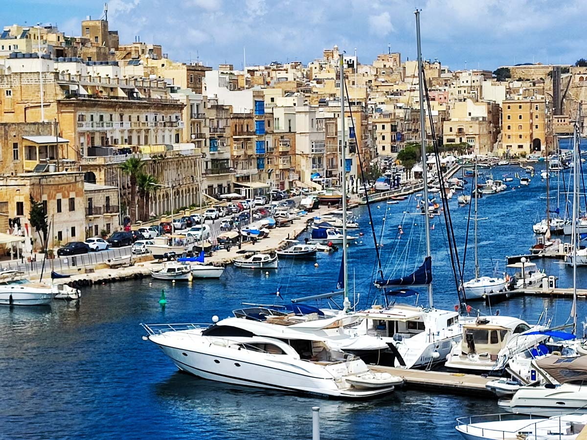
Malta attractions, map, sightseeing plan, tours, the most beautiful places, bus map
Where is Malta?
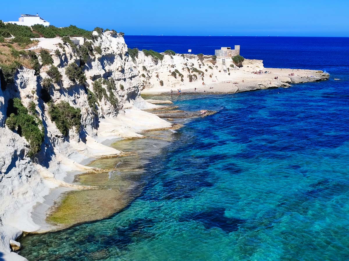
Malta is a small island. So small that compared to, for example, Sicily, it looks like a pinhead. Sicily is Malta's closest neighbor (the islands are about 100 km apart). If you look at the map more broadly, it would turn out that Malta lies practically in the middle of the Mediterranean Sea, dividing it almost evenly into two halves (east and west of Malta).
To better illustrate the location and size of Malta, I have prepared an appropriate map.
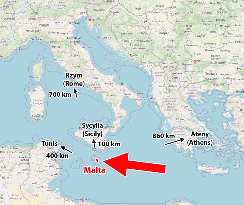
The red dot pointed to by the big red arrow is Malta. The size of the red dot more or less reflects the size of the island. To the north of Malta you can see Sicily. The difference in the size of the islands is clearly visible.
I also marked other interesting places on the map. Note that Malta is about 700 km closer to the equator than Rome. It is also further south than Athens (the capital of Greece) and Tunis (the capital of Tunisia in Africa). This - as you can guess - has a direct impact on the climate and temperature on the island (but more on that later).
How big is Malta?
Malta is an island state made up of an archipelago of islands. The most important and largest are three of them:
- Malta (the main island bears the same name as the state),
- Gozo (the second largest island of the Maltese archipelago)
- Cumin (officially inhabited by 2 people, the smallest inhabited island of Malta).
The other islands are much smaller and uninhabited.
The sizes and relative position of the islands are shown in the picture below.
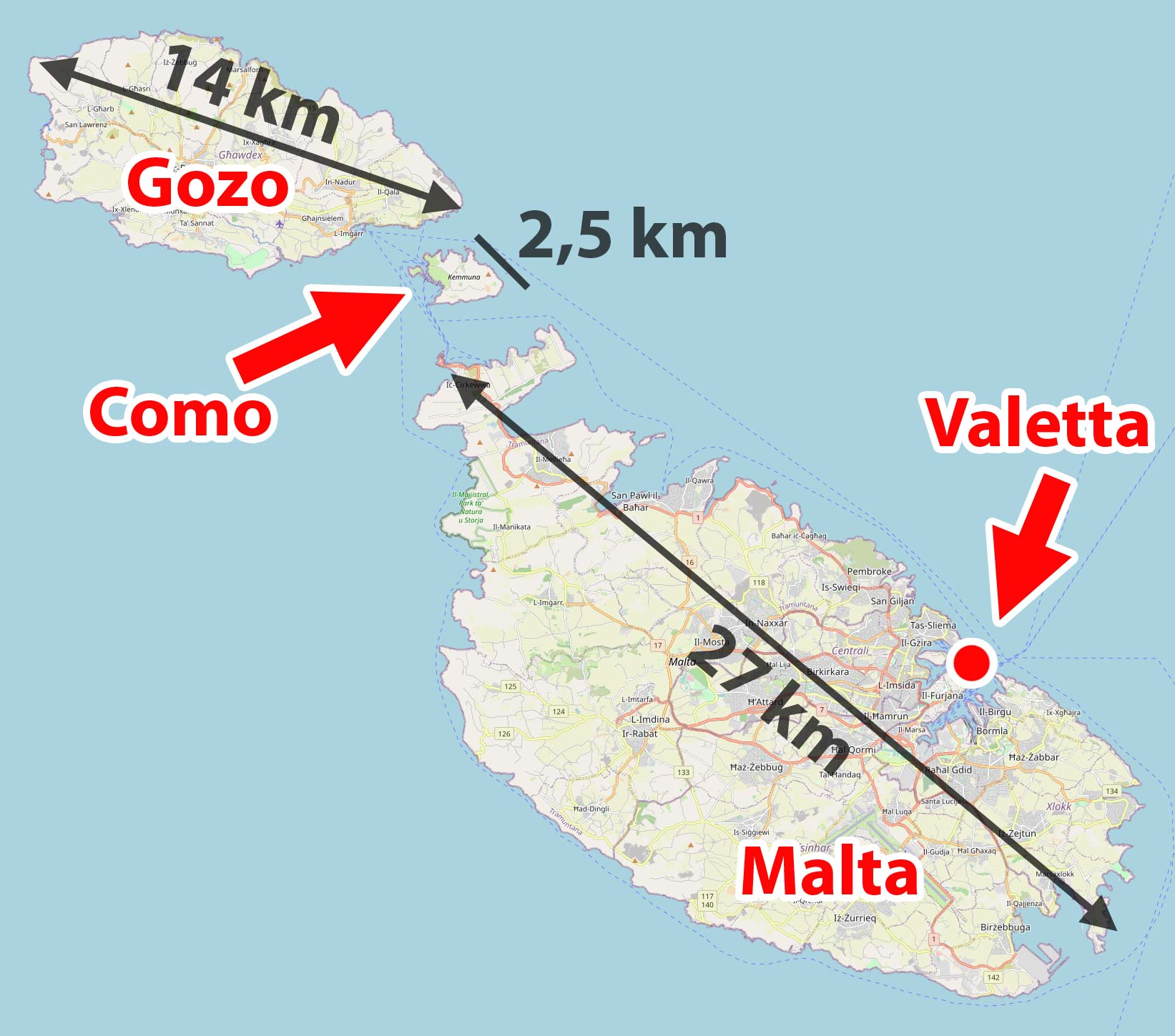
The largest island, or Malta at its longest point in a straight line, it is about 27 km long, and its width does not exceed 13 km. If you plot a road connecting the two most distant points in the navigation, it turns out that the length of the route to be covered by car from the end to the end of the island is 37 km, and it will take about 1 hour to drive it.
On the largest island there is the capital of Malta (Valletta), the airport connecting Malta with the rest of the world and a rich tourist, hotel and gastronomic base. The main tourist traffic is concentrated here.
Second the largest island (Gozo) is 14 km long and 7 km wide. The length of the route connecting the two most distant points on the island is 15 km, and its journey by car will take about 30 minutes. The island has a much more modest tourist base, but it is extremely attractive, mainly due to its fantastic natural and landscape values. The easiest way to get to Gozo is from Malta with a regular ferry service, transporting people and cars.
Comino's third largest it's a real baby, 2,5 km by 2 km. In a few dozen minutes you can walk it from end to end on foot.
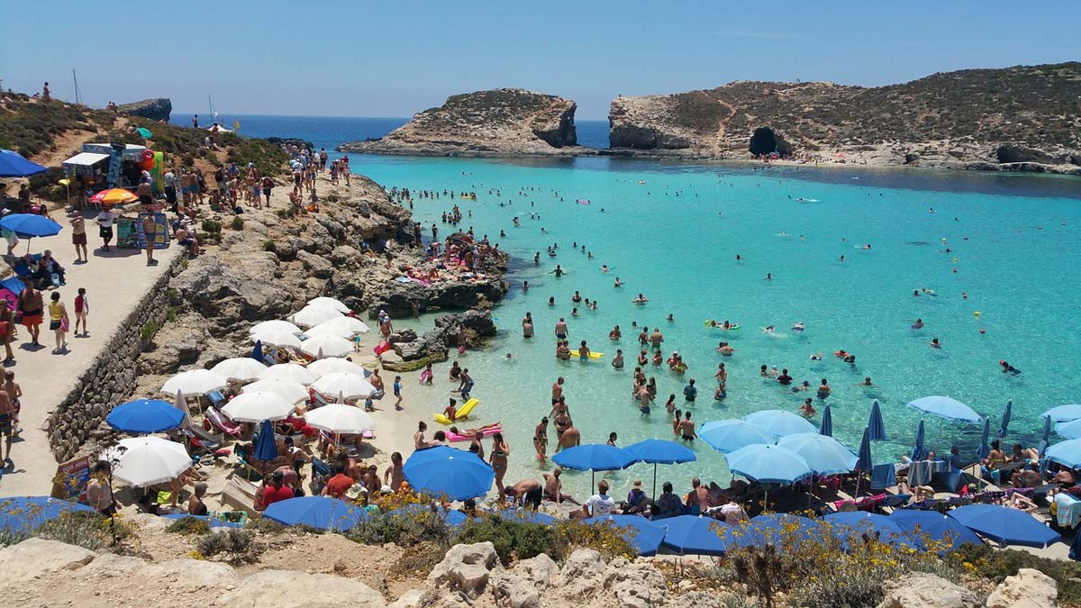
Malta's most famous beach is located on Comino, i.e Blue Lagoon.
Two faces of the island
Despite its small size, Malta has a lot to offer. Lovers of lazy relaxation will find something for themselves here, as well as those who are unable to stay in one place for a long time and constantly have to go somewhere.
The first group (those who like lazy holidays) gets a dozen (or even more) beaches scattered all over the island. The beaches are of different nature and very diverse scenery. There are rocky, rocky and sandy beaches. Close to the city and remote, crowded and empty, with and without beach infrastructure. Some are flat, and others are located among the rocks or even under a steep cliff. The small size of the island makes each of them easy to reach, so the choice is really wide. Everyone will find their favorite.
Enthusiasts of active recreation will find plenty of walking paths in Malta, which stretch along almost the entire coastline. In addition, several beautiful, atmospheric towns, viewpoints, caves and other wonders of nature, and buildings so old that it is hard to believe (the oldest of them were built 1 years earlier than the pyramids in Egypt).
Lovers of newer history and militaria will also not be able to get bored. Due to its strategic location, the island has been an important military bastion for centuries. Spectacular military-defensive buildings are almost everywhere here, and large fragments of urban buildings consist almost exclusively of them. The number of bastions, forts, citadels and towers per square meter exceeds all limits of reason here. There are so many of them on the island that many of them have not been renovated since the end of World War II and are waiting for their turn (he simply has no idea what to do with them). I can't imagine that there is someone who, after visiting Malta, will not have enough defensive buildings 🙂
Only those who like to be surrounded by greenery, beautiful plants and forests can be disappointed with Malta. In Malta, forests are practically non-existent, and ordinary greenery is also scarce. The landscape is rather dry and sandy and rocky. There is nothing to count on paradise oases immersed in lush greenery and it is not worth wasting time looking for them.
How to visit Malta?
Choosing how to travel and explore Malta is a key decision. Everything depends on her. The construction of the plan should start with the decision on how to move around the island.
How was my case? Of course, the Internet and other people's experiences were the basis for my search for the best solution. Unfortunately, in practice it turned out that what seemed to be the best choice (moving by public transport buses), in practice is not the best choice for me at all. During my stay, I had to change the main means of transport (I rented a car) and build the whole plan from scratch.
I know it's the complete opposite of what most sites say, but I'm describing my own experiences, and they don't have to be identical, and I think it's even better that they're not.
What happened? Why did I change my mind during the trip? Everything will be explained in the following paragraphs!
Public transport
The commonly functioning opinion about public transport in Malta is as follows:
public bus transport in Malta is well developed, it allows you to move around the island and reach most of the attractions.
And that's the truth! Needless to say that Malta boasts a large number of bus lineswhich serve practically the entire island, but … there is always a but. The devil is in the details, and we'll get to those details in a moment. First, however, a solid dose of facts and information about the communication itself.
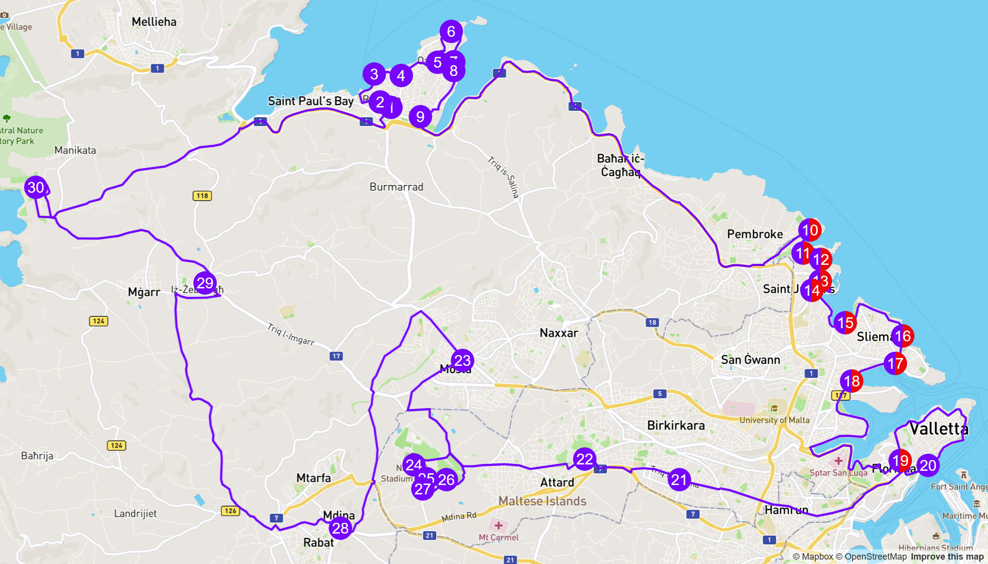
First, a map of bus routes. You can download it in high resolution as a PDF from the link below.
download: Malta and Gozo – PDF bus route map – [click]
The latest map I was able to find comes from 2020 and generally corresponds well to the current state of affairs. Currently, there is no new map in the form of a downloadable file on the official website of the bus operator. There is access to it current routes online, one for each line. In my opinion, it is less practical and useful, but for our needs the map from 2020 is enough.
At first glance, the map may seem difficult to read, but I will introduce a small modification to it that will clarify a lot and make using the original connection map immediately easy. Look at the picture below.
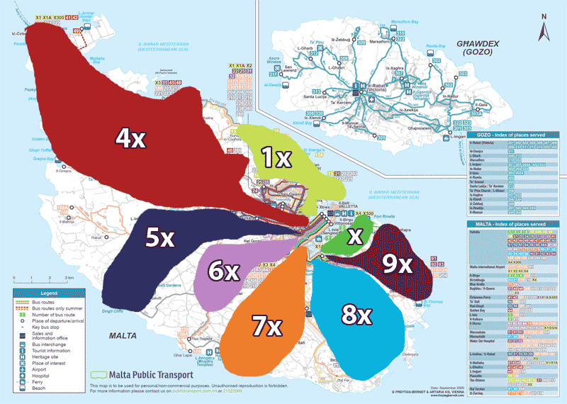
I added colored areas to the map of bus routes and marked them. More or less like in this picture, the bus operator divided the whole of Malta and within this division he designated bus lines, giving them the appropriate numbers. In this way, after the first digit of the bus number, we immediately know which area of Malta the given line serves. Buses with the same first digit, e.g. 71 and 73, will therefore serve the same area, but their route will be slightly different.
As you can see from the map above, the bus lines in Malta have a star-shaped layout and the overwhelming majority of them start in the same place: in Valletta. In practice, this means that when you go to visit an attraction located in area number 5x (e.g. Dingli Cliffs), you will not be able to get easily and quickly to an attraction located in another area, e.g. Golden Bay located 9 km away (Golden Bay) in 4x area. You will need to return to Valletta, where you will change to the 4x area bus to Golden Bay and only then will you arrive at your destination (then it will take approximately 2 hours just to drive between the attractions). Of course, no one in their right mind will plan their trip in this way, assuming traveling by bus, but without this knowledge it could happen 🙂
Fortunately, there are single lines between some areas that connect them (e.g. line 201 connecting 5x, 6x and 7x areas). Generally, these are lines that have numbers starting with "100" and "200". There are really a lot of them and without a detailed analysis of the timetable and maps, you will not be able to do it here. However, another problem may arise here. This is a problem that affects all lines, not just those connecting areas. A bus that is full may not stop at the stop, and contrary to appearances, this is not a rare situation. In the season when Malta is full of tourists this happens quite often.
It wouldn't be a problem if the buses ran often enough, but most of them run about every 30-60 minutes. Waiting in full sun for another hour sitting in an open field on a stone can get boring quickly.
The entire above description of the functioning of bus lines in Malta has been prepared for one extremely important reason, which should make you very happy, and at the same time simplify your life. I decided to adapt the numbering of tourist attractions on the map to the numbering of bus lines. The number of each attraction therefore consists of two parts. The first digit is the number of the area (identical to the bus lines serving this area), and the second digit is the number of the attraction. What does it give us? Well, immediately after the number of attractions, even without delving into the map, we know within which bus lines the attraction is located. We also know that if one attraction has the number 8.1 and the other 4.3, we probably can't combine them in one trip. Trivially simple, effective and useful.
Hop On - Hop Off buses
Coaches Hop on - hop off that is, in short HO HO is a separate category of buses. It can be useful for many people, mainly those who do not want to play around arranging trips based on city buses, and at the same time do not want to rent a car on the island.
There are two main HOHO lines in Malta: northern line i south line. Their routes mostly do not overlap, although they also have common stops. The course of both routes is closely related to the greatest attractions of the island and both have stops near each of the attractions you pass. Driving through them, you will see basically everything that you should see in Malta.
How do HOHO buses work?
The principle is simple. Bus tickets are valid all day (there's also a two-day version) and during that time you can get on and off as many times as you like. During the ride, headphones are available through which the lector in the selected language talks about the passed or upcoming attractions. The voice-over is currently available in thirteen languages: English, Spanish, French, German, Italian, Japanese, Chinese, Portuguese, Russian, Polish, Danish, Finnish and Maltese.
Some people simply get on the bus and travel the entire route, listening to the narrator's story and admiring the attractions from the bus. The hop-off journey takes 3,5 hours on the northern route and 3 hours on the southern route.
Most people, however, use HOHO buses a little differently. He chooses the stops on the route where he wants to get off in order to spend more time at the selected attraction (e.g. to visit the town or megalithic temples) and returns to the stop when the next HOHO bus arrives there. The average interval between successive buses is about an hour. This is enough time to get acquainted with any of the selected attractions and return to the stop.
HOHO Bus Schedule (2023)
On the northern line eight buses leave daily. They depart from the Bugibba stop (Topaz Hotel/Pebbles Hotel) at the following times:
– 08:00, 09:00. 10:00. 11:00, 11:30, 12:30, 13:30, 14:30
Buses on this line run every Monday, Wednesday, Friday and Saturday.
Bugibba (Topaz Hotel/Pebbles Hotel), GPS coordinates of the stop:
35°56’48.8″N 14°24’43.8″E
35.946875, 14.412177 - click and route
On the southern line Six buses leave daily. They depart from the ITS Roundabout stop (Radisson & Corinthia Hotels Roundabout) at the following times:
– 09:05, 10:05, 11:05, 12:05, 13:05, 14:05
Buses on this line run every Tuesday, Thursday and Sunday
ITS Roundabout (Radisson & Corinthia Hotels Roundabout), GPS coordinates of the stop:
35°55’43.4″N 14°29’22.8″E
35.928715, 14.489674 - click and route
Therefore, when planning transfers between successive buses, remember not to plan a transfer when the last bus is on the route, because there will be no way to return 🙂
Then only the city bus or taxi (Bolt or Uber) will remain.
HOHO bus tickets
Tickets for HOHO buses can be purchased in advance online. The carrier has such a sales policy that (as I write these words) on the distributor's website - [click] tickets can be purchased almost €3 cheaper (€28) than on his own site (€30,77). This is no surprise. Many facilities get rid of the problem of handling ticket sales and use ready-made systems (e.g. the Louvre museum in Paris no longer sells tickets at the box offices and does it only online, on the same website as Maltese HOHO buses).
HOHO bus tickets are valid for 12 months from the date of purchase. During this time, they can also be returned for a full refund. Tickets are activated only when you board the bus for the first time, and from that moment the time of 24 or 48 hours is counted down, during which you can freely use the HOHO line.
Holders of e-tickets must choose one of two stops for their first stop (both lines pass through them):
– Valletta Waterfront Terminus
– Sliema Ferries
Only at these two stops there are devices that allow you to activate electronic tickets. However, this is not a major problem, because both stops are close to the main transport hubs, which you usually pass through anyway.
The departure times of HOHO buses from these stops are at least several minutes (or a little more) later than from the starting stops.
check out: HOHO bus tickets in Malta – [click]
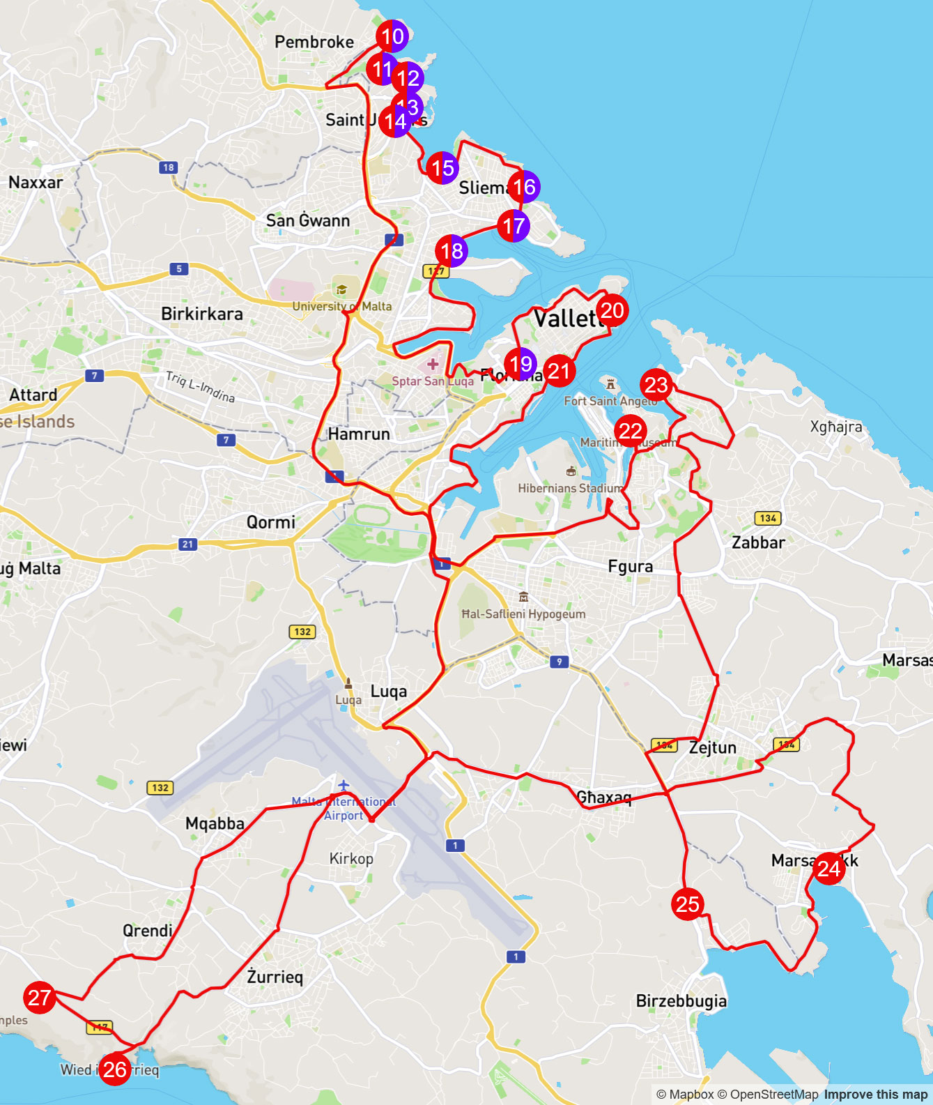
Detailed routes of HOHO buses
To complete happiness, we only need full descriptions of the routes of both HOHO bus routes.
Northern route map and stops with the original numbering of stops as on the carrier's maps:
Stops on the northern route
• (1) Bugibba (Hotel Topaz / Hotel Gillieru)
• (2) Bugibba (Pebbles Hotel)
• (3) Bugibba Jetty (Seatrips Hotel)
• (4) Bugibba Center (opposite HSBC)
• (5) Bugibba (Hotel Santana)
• (6) Malta National Aquarium
• (7) Qawra Palace Hotel
• (8) Qawra Promenade
• (9) Hotel Bellavista, Qawra
• (10) Rondo ITS (Radisson and Corinthia hotels)
• (11) St George's Bay, St Julians (city sightseeing stage)
• (12) Westin Dragonara, St. Julians
• (13) Hilton Roundabout, St Julians
• (14) Spinola Bay, St. Julians
• (15) Balluta Bay (Opp Balluta Church)
• (16) Sliema Quay (opposite the Preluna Hotel)
• (17) Sliema Ferries (city tour and harbor cruise stop)
• (18) Opposite the Bayview Hotel (CitySightseeing Outlet)
• (19) Valletta - city centre
• (20) Valletta Waterfront Terminus (Southern interchange)
• (21) Farsons Brewery
• (22) San Anton Gardens
• (23) Mosta Church
• (24) Ta Qali - Aviation Museum
• (25) Valletta Glass
• (26) Mdina Glass
• (27) Ta Qali (craft village)
• (28) Mdina - main gate
• (29) Skorba
• (30) Golden Bay
Map and stops on the southern route with the original numbering of stops as on the carrier's maps:
• (10) ITS roundabout
• (11) St George's Bay, St. Julians (CSS tour leg)
• (12) Westin Dragonara, St. Julians
• (13) Hilton, St. Julians
• (14) Spinola Bay, St. Julians
• (15) Balluta Bay (Opp Balluta Church)
• (16) Sliema Quay (opposite the Preluna Hotel)
• (17) Sliema Ferries (city tour and harbor cruise stop) opposite Bayview Hotel
• (18) Opposite the Bayview Hotel (CitySightseeing Outlet)
• (19) Valletta - city centre
• (20) Valletta - Fort. St. Elmo
• (21) Valletta Waterfront Terminus (Northern interchange)
• (22) Birgu Wharf (Vittoriosa)
• (23) Esplora Interactive Science Center
• (24) Marsaxlokk fishing village
• (25) Ghar Dalam Cave
• (26) The Blue Grotto
• (27) Hagar Qim Temples and Mnajdra Temples
map source: city-sightseeing.com
Car rent
At the end, I left to discuss my preferred form of moving around the island, i.e. renting a car. Originally, he was not a supporter of it, mainly due to the prevailing left-hand traffic here, the small size of the island and available bus transport. Eventually, life verified my view and I changed my mind. It is enough to sit for an hour in the sun on a stone, waiting for a bus that will not arrive as planned anyway. It is enough that the overcrowded bus will not stop at the bus stop and you will have to wait hopefully for the next one. It is enough that you will have to visit attractions in a hurry so as not to miss the next bus ... you start to look at bus connections differently. That's why I changed my mind and rented a car for the remaining four days of the trip. What a relief!
In retrospect, I believe it was the best possible decision. I rented the car exactly as described in the car rental guide in Malta - [click]. I paid a total of around EUR 100 for a car with full insurance. I would have paid cheaper for bus tickets (€42 for a week for two people), but what if the family has more than two people? The car still costs the same, and the cost of tickets increases with each person and it is no longer so profitable. In addition, if you have children with you on the trip and you still want to visit something, then wandering around by buses becomes really tiring.
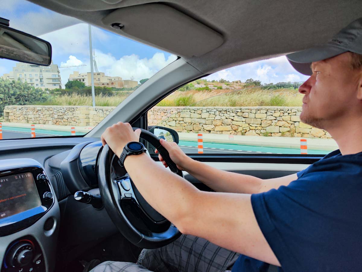
There is left-hand traffic in Malta and this was a big concern for me. In practice, left-hand traffic turned out to be not as scary as I originally thought. The first minutes and even hours were of course stressful and I kept maximum focus. In the evening, after a day of driving, I was very tired, but after a good night's sleep, on the second day I was driving quite well and then it was fine. Ultimately, it turned out that Malta is a very good place to learn how to drive on the left side. Driving around the island is very slow and in most places there is a speed limit of 40 or even 30 km/h. For the first time in my life I enjoyed such speed limits. There is plenty of time to react everywhere, so the pressure on the driver is somewhat less.
Speed limits on the fastest, two-lane road sections allow you to drive at a speed of 70-80 km/h, which is still quite slow and safe.
The greatest difficulty is the common narrow sections of two-way roads (sometimes even dirt roads), which can accommodate only one car. Then driving in both directions takes place alternately and you have to give way to each other, hiding in the bays that appear from time to time. You have to be patient and not rush anywhere, which suited me as a driver who had no experience in driving on the left side of the road and, paradoxically, made the job easier.
I gained another argument for renting a car when we went to explore a neighboring island: Gozo – [click]. Bus transport in Gozo also operates, but it is not as well organized as in Malta. Getting to most of the attractions in Gozo by bus would be impossible or much more troublesome (you have to walk a long way from the stop), and moving between attractions requires returning to the capital of the island each time. Seeing what we were interested in in one day would be impossible. By car, around 10:00 in the morning we boarded the ferry and quickly crossed over Gozo. Then we drove around the entire island, easily reaching every attraction, and in the evening (around 18.00 p.m.) we left again for the ferry that took us back to Malta. In my opinion, there is no better way to enjoy sightseeing Gozo, and the island offers plenty of attractions and is truly stunning in its beauty.
To sum up: contrary to most opinions I think renting a car is a good idea and if I was going to Malta again, I would definitely do it. The costs of renting a car do not destroy the wallet, and the freedom and comfort gained in return in planning sightseeing definitely compensate for a slightly higher expense.
Before renting a car, be sure to read it prepared by me car rental guide in Malta – [click]. I think it can help you a lot to tame the topic.
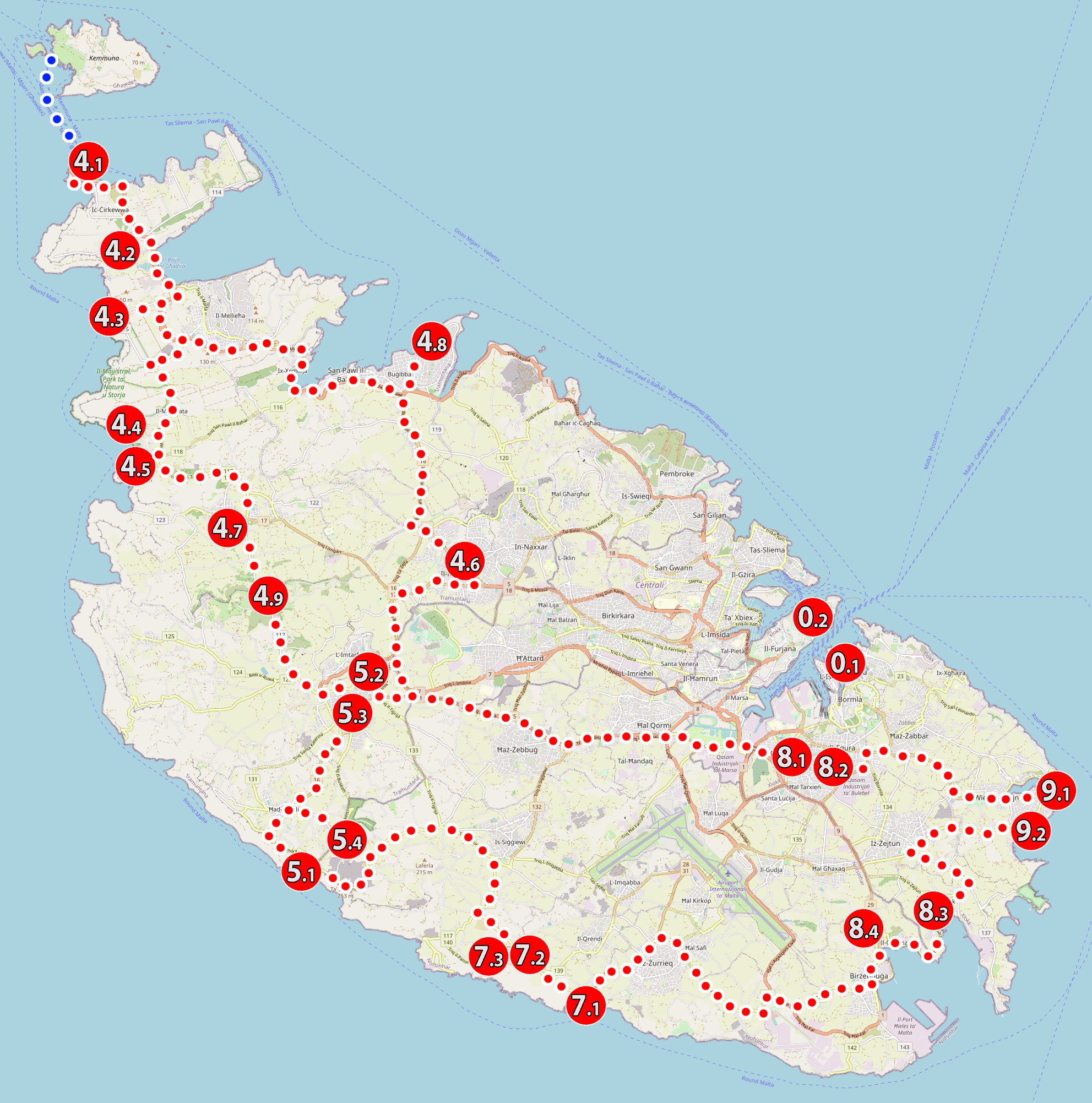
Malta attractions map
It's finally time to plan your visit to specific attractions on the island. To start with, a map of Malta with tourist attractions will come in handy, giving you a good idea of how the most interesting places on the island are located.
As I mentioned earlier, the numbering of attractions is not accidental and is directly related to the numbering of bus lines serving the island. If you missed this information, be sure to go back to the section describing bus transport on the island and everything will become clear.
WARNING!
The above map is also available as a PDF file, prepared for easy use on a phone. Attraction markers on the map are active and open additional data about each attraction (including GPS navigation data).
Description of use and link to download Malta PDF map you will find in a separate entry: Malta – tourist map PDF – [click]
Malta sightseeing plan by public transport
Here the plan seems simple. My suggestion is that:
– based on the numbering prepared by me, choose one zone that interests you on a given day (e.g. 7x, where there are megalithic temples and the Blue Grotto) and go explore it. Depending on how the situation develops during the day, decide what to do next. If the sightseeing goes smoothly and it turns out that you can visit more things that day, then choose another zone, return by bus to the main stop in Valletta and explore further (or if possible, take a bus connecting different zones, such as line 201).
– build a sightseeing plan for the next few days, depending on the development of the situation, strength and willingness.
Below the descriptions of each attraction, you will find the numbers of bus lines that stop near it.
you may find it useful: the official website of public transport in Malta and the timetable of all buses - [click]
Malta sightseeing itinerary with HOHO buses
There is nothing to think about here. You already have the division and the sightseeing route imposed in advance. All you have to do is choose which stops you want to drop off at to explore the attractions located near them. There can't be too many of these stops (about 4-5, depending on the line), because you have to stick to the line's operating hours.
Malta sightseeing plan by car
This is the version for those who like the freedom to travel and explore. I could write: go where you want and visit what you want, but of course I have prepared a ready plan that you can use in its entirety or treat it only as an inspiration and make your own modifications.
It seems to me the most sensible to divide the tour into four days (then whole days are filled with various activities):
- the first day: Valletta and Birgu (Vittoriosa)
- day two: the southern part of the island
- day third: northern part of the island + Comino
- fourth day: island of Gozo
Of course, this is only a proposal that you can freely modify for your own needs and interests.
Most tourists come to Malta for seven days, so you'll have three days left. If you are interested in militaria, then probably spending one day to see everything in the capital of the island and its surroundings (museums and forts in Valletta, Silema and Birgu) will definitely not be enough. So you can allocate another day for that. I also suggest setting aside some time for a simple beach holiday. In Malta, you can visit a different beach every day, and there are some really beautiful places to choose from. On the blog you will find descriptions of selected ones.
Even the most remote beaches can be reached in less than an hour by car, so basically you can go anywhere you want.
The presented division into days is conventional and you can implement the plan in any order. Each day is a separate and independent trip.
Day one – visiting Valletta and Birgu (Vittoriosa)
Detailed sightseeing plan Valletta i Birgu will be the subject of a separate entry. Here I will only mention that I suggest starting your tour from Birgu (1), where it is worth taking a pleasant walk, ending it near the fort Saint Angela. From here, for a small fee (EUR 2 per person), you can take a short cruise around the harbor and get off at the Valletta wharf, then explore Valletta.
A highly simplified itinerary presenting my idea for sightseeing can be found below.
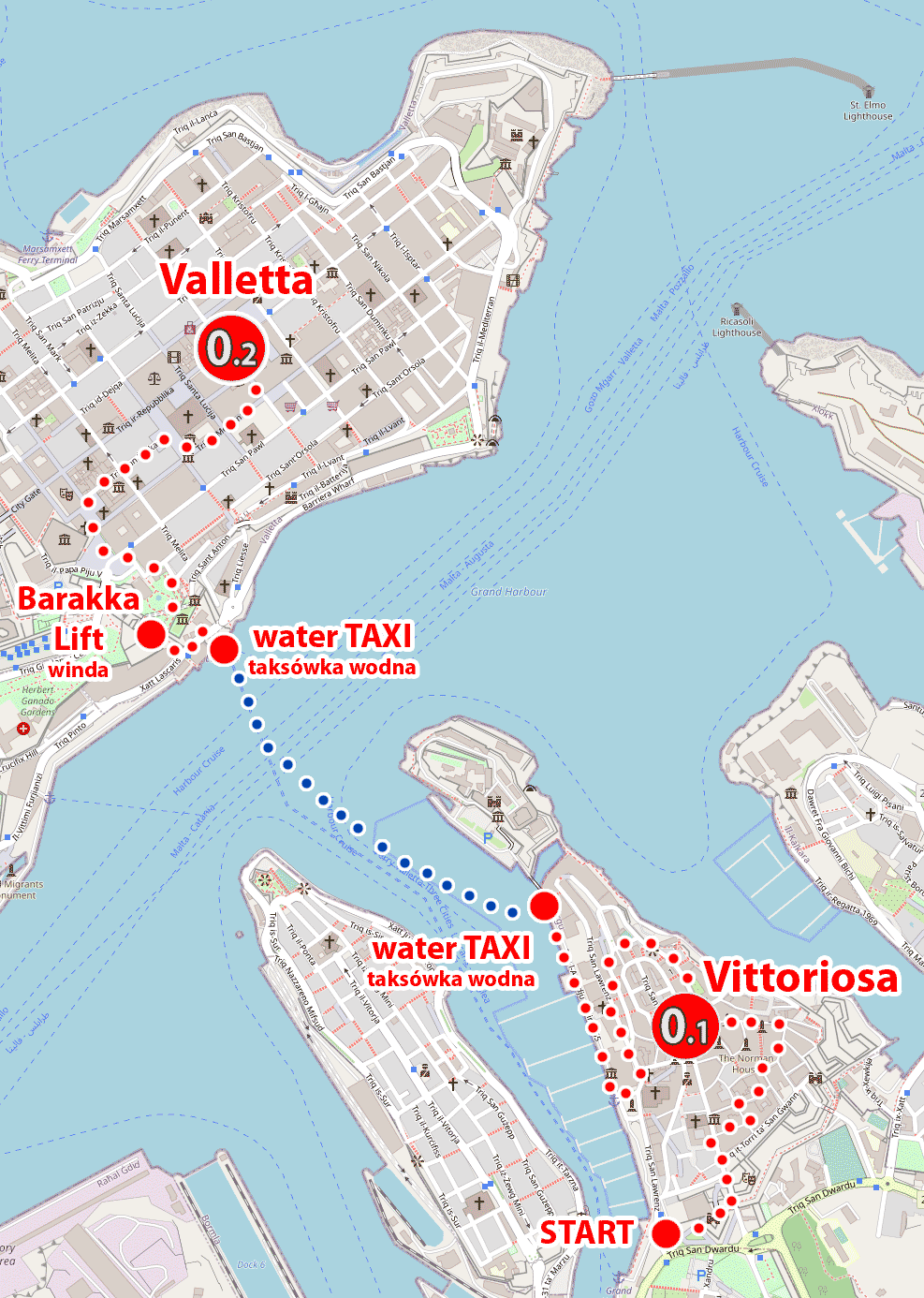
Thanks to such planning of the trip, you do not waste time on uninteresting bus rides, and a boat trip from Vittoriosa (Birgu) to Valletta is a great and cheap attraction and a way to see the port and city buildings from a very interesting perspective.
Note that the numbering of attractions here starts with the first digit "0". Attractions with the first digit "0" are served by bus lines, with a single-digit number, i.e. 2, 3 ... etc. In my numbering, I simply put "0" instead of a blank space.
Birgu - START of the walk, GPS coordinates:
35°53’05.5″N 14°31’16.8″E
35.884851, 14.521346 - click and route
Riche - bus stop near the START of the walk
lines: 2, 3, 4 stop
GPS coordinates of the stop:
35°53’07.0″N 14°31’24.4″E
35.885288, 14.523451 - click and route
Birgu - water taxi, GPS coordinates of the place from which the boats depart:
35°53’25.1″N 14°31’09.7″E
35.890314, 14.519346 - click and route
Barakka Lift to the center of Valletta, GPS coordinates:
35°53’39.8″N 14°30’43.2″E
35.894393, 14.512012 - click and route
Valletta downtown, GPS coordinates:
35°53’50.8″N 14°30’44.1″E
35.897450, 14.512253 - click and route
Day two – the southern part of Malta
It will be a day full of various attractions. Filled with amazing historical objects (exceptional unique in the world), intertwined with brilliant natural scenery and captivating landscapes. Undoubtedly, there will be countless emotions and memories after that day, and the shutter of the camera will be red hot. I suggest you charge the battery to 100%, prepare a lot of space on the memory card and off we go!
The sightseeing route looks like this:
(8.1) Hal Saflieni Hypogeum - (8.2) Tarxien Temples - (9.1) Marsaskala Salt Pans - (9.2) St. Thomas – (8.3) Marsaxlokk – (8.4) Ghar Dalam Cave – (7.1) Blue Grotto – (7.2) Hagar Qim Megalithic Temple – (7.3) Mnajdra Megalithic Temple – (5.1) Dingli Cliffs
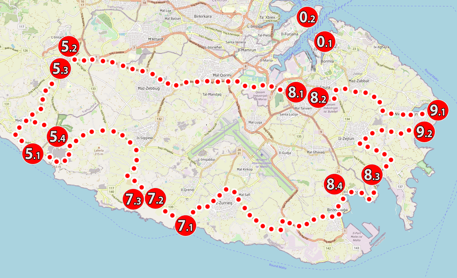
However, the beginning of the tour may not be as dynamic and spectacular as we would like, because the UNESCO list goes first Hal Saflieni Hypogeumto which - let's face it - most of you will not be able to enter. Hypogeum tickets sell out well in advance, and entry must be booked at least a month, preferably two months in advance. The number of tickets is very very small. A maximum of 10 people are allowed inside at a time, and only 8 such groups can enter during the day.
It is definitely better with the availability of the second and all subsequent attractions. There shouldn't be any problem accessing them.
Depending on the pace of your visit and the amount of attractions you decide to visit (or skip) along the way, you may have some energy and time left at the end of the day. If that's the case, you can easily make use of that time by visiting the next two places that you'll probably pass through on your way back from today's trip. They are: (5.2) Mdina and (5.3) Rabat. This will free up a lot of time that you will use the next day.
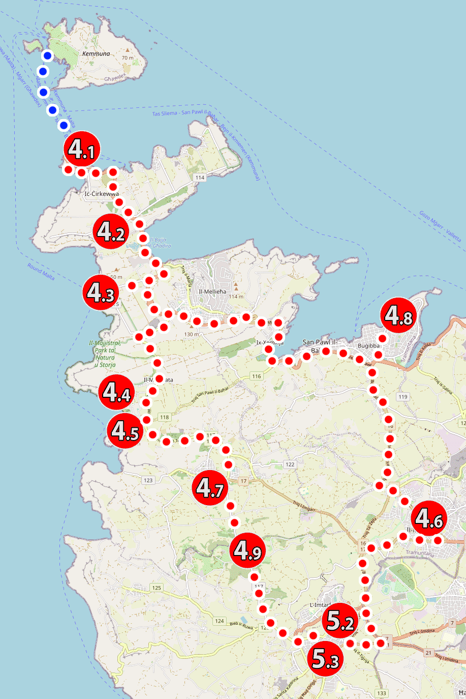
Day three – the northern part of Malta and Comino
On this day, I suggest getting up a little earlier. The tour begins with a quick trip to the parking lot, from where the ferries depart to the island of Comino. I suggest getting on the ferry as early as possible, before it gets hot and before the main wave of tourists arrives on Comino.
You can go to Comino without a car. You have to leave your car in the free car park at the marina and this is another argument to be here earlier. The parking lot fills up quickly and then there are no spaces left. You need to look for a parking space in the vicinity.
The first ferry to Comino departs at 8:30 AM, then every half hour until 16:00 PM. Ticket price €15 (2023)
A detailed schedule of flights and current prices can be found on the carrier's website: Comino Ferries – [click]
Comino can also be reached from other places in Malta (e.g. from Bugibba or Sliema near Valletta). Most often, these are cruises that last a few hours and other places are also visited along the way. Then you need to allocate one whole day for this attraction. If you don't have a car, and you don't want to bother with the bus, then you can go on such an all-day cruise. Prices start from EUR 25.
For your convenience, I have prepared a special link that generates a list of currently available trips to Comino and filters out most of the attractions that are not related to this topic and unnecessarily clutter the offer.
see: offer of cruises to Comino from various places in Malta – [click]
Coming back to our itinerary: of course, it assumes that a trip to Comino will not take you the whole day and you will spend only the first half of it. In the second half of the day we start exploring Malta; but do not worry! We will not run out of beaches, because the next points of the program are more beautiful beaches, as well as viewpoints and climatic towns. It's going to happen!
The sightseeing route looks like this:
(4.1) Comino Ferries (cruises to Comino) – (4.2) Saint Agatha Tower – (4.3) Popeye Village – (4.4) Golden Bay Beach – (4.5) Riviera Beach – (4.7) Ta Hagrat megalithic temple – (4.6) Mosta – (5.2) Mdina – (5.3) Rabat – (4.8) megalithic Bugibba Temple
Day four - visiting the island of Gozo
Na visiting Gozo – [click] you need to allocate a whole day, and you will only be able to complete the plan I have proposed if you go (actually sail) to Gozo by car. It is neither expensive nor complicated.
Without a car, you won't be able to complete the itinerary I've suggested, and traveling to Gozo just to see two or three things is pointless. It's like licking a lollipop through the paper.
So I am not proposing any alternative plan. It's a waste of time and money. I recommend renting a car and thoroughly exploring the island. Gozo is small and delightful. Many people like it even more than Malta and there is no exaggeration in that. It's a pity not to take advantage of this opportunity.
Visiting Gozo requires writing a separate itinerary. Here, I only signal the need to book the whole day for it, and a detailed description of the tour can be found in a separate entry: Gozo – map and sightseeing plan [click]
Descriptions of attractions in Malta
0.1 Birgu (Vittoriosa)

Birgu is a small medieval town located on one of the promontories in the southern part of the Grand Harbor. Since the arrival of the Knights of the Order of St. John to the island, Birgu has been the headquarters of the Order of Malta and the capital of Malta. In 1571, a change came and the role of the capital was taken over by Valletta. The importance of Birgu on the island was so great that anyone who wanted to take control of Malta first had to take control of Birgu.
The promontory on which Birgu is located is crowned with the heavily fortified buildings of Fort Saint Angelo. The upper part of the fort is still occupied by the Sovereign Knightly Hospitaller Order of Saint John and this part of the building is practically treated as the territory of a separate state belonging to the Order of Malta. The relevant agreement between Malta and the Order was signed in 1998, then ratified in 2001 and remains in force for the next 99 years.
Birgu - START of the walk, GPS coordinates:
35°53’05.5″N 14°31’16.8″E
35.884851, 14.521346 - click and route
Riche - bus stop near the START of the walk
lines: 2, 3, 4 stop
GPS coordinates of the stop:
35°53’07.0″N 14°31’24.4″E
35.885288, 14.523451 - click and route
Birgu - water taxi, GPS coordinates:
35°53’25.1″N 14°31’09.7″E
35.890314, 14.519346 - click and route
0.2 Valletta
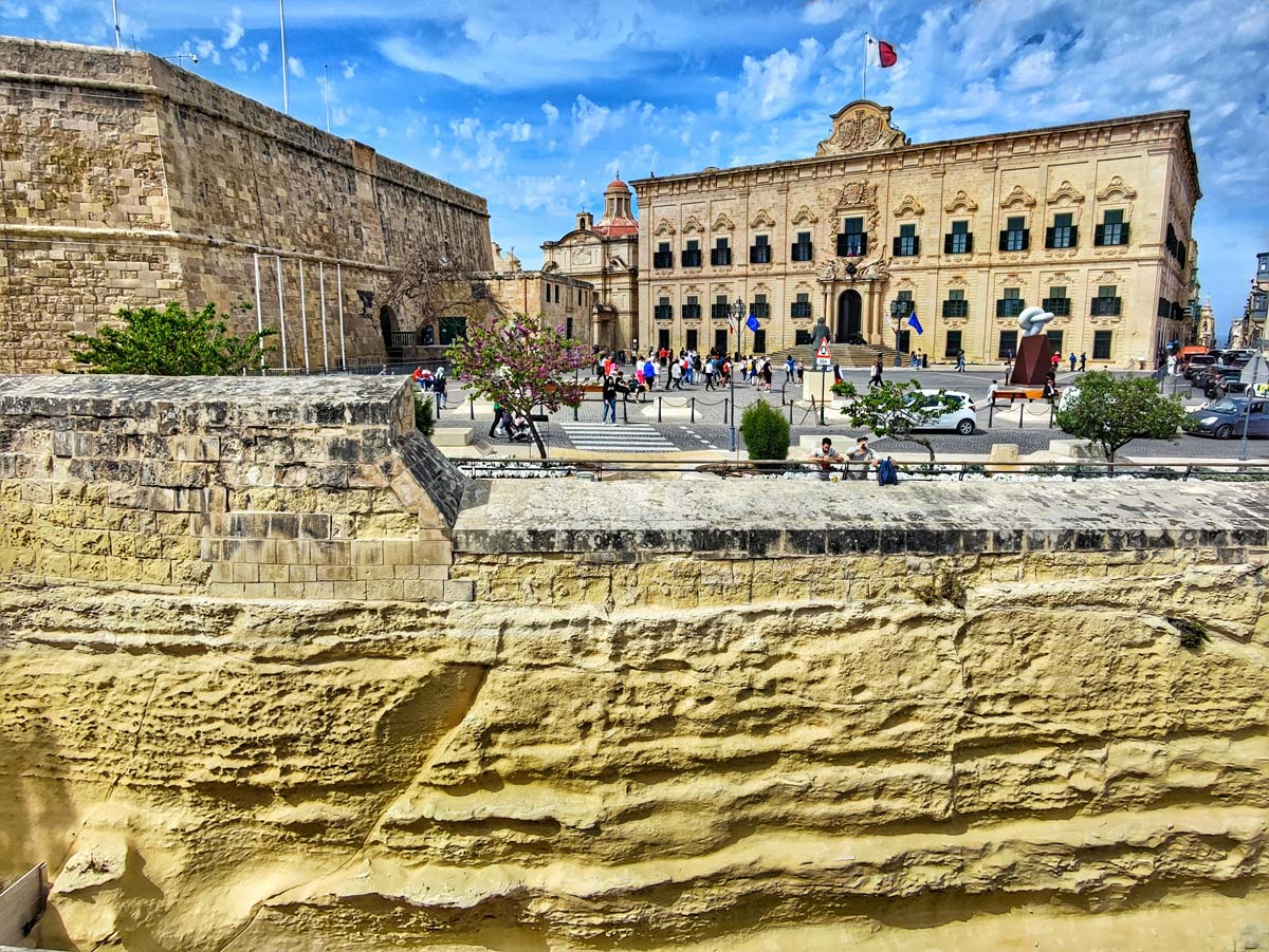
Valletta is said to be the smallest capital in Europe. Is it true? The answer to this question can be: YES - and it will be true. You can also answer: NO - and it will also be true! It depends on which parameter we take into account.
If we take into account the area of the city, Valletta is actually the smallest, because its area does not exceed 1 km2 (exactly 0,8 km2). However, if we take into account the number of inhabitants, the capital of Malta with a population of 6000 people lands only in fourth place. Smaller than it are:
– Vatican City (capital of the Vatican City): about 800 people
– San Marino (capital of San Marino): about 4500 people
– Vaduz (capital of Liechtenstein): about 5200 people
Anyway, Valletta is a tiny city, almost entirely filled with large and heavy, old buildings, a large part of which are military and defense buildings. The historical part of the city consists almost exclusively of valuable historical buildings and as a whole has been entered on the UNESCO cultural heritage list. On the previously mentioned area of 0,8 km2, there are about 320 legally protected historical buildings. No wonder that Valletta has earned the name "open air museum".
Visiting Valletta is therefore simple: just walk wherever you want.
Valletta city center (near St. John's Cathedral), GPS coordinates:
35°53’50.8″N 14°30’44.1″E
35.897450, 14.512253 - click and route
Valletta - the city gate, GPS coordinates:
35°53’46.1″N 14°30’32.8″E
35.896149, 14.509119 - click and route
Valletta - parking near the walls and entrance to the historic part of the city, GPS coordinates:
35°53’38.0″N 14°30’17.5″E
35.893881, 14.504866 - click and route
4.1 Comino Ferries - cruises to Comino
This point of the tour indicates where the car park is located, where you should leave your car when taking a boat trip to Comino. Unfortunately, the parking lot at the ferries in Comino fills up quite quickly and then you have to look for a way to park elsewhere. Below you will find information on the second, capacious and close to the car park.
check out: cruise schedule to Comino – [click]
see: offer of cruises to Comino directly from holiday resorts in Malta - [click]
Cirkewwa - bus stop near the ferry to Como
lines: 41, 42 stop
GPS coordinates of the stop:
35°59’14.3″N 14°19’44.4″E
35.987300, 14.329006 - click and route
Parking by the ferries to Comino, GPS coordinates:
35°59’16.4″N 14°19’46.9″E
35.987881, 14.329702 - click and route
Second car park near the ferries to Comino, GPS coordinates:
35°59’12.6″N 14°19’53.0″E
35.986822, 14.331395 - click and route
4.2 Saint Agatha's Tower
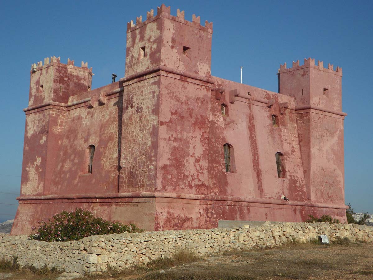
Traveling around Malta, you will certainly pay attention to the fortified, rectangular coastal towers visible from time to time. Their main purpose was not typical defensive purposes, but rather observation, protection and signaling. The constant observation of the sea conducted from them made it possible to detect the approaching threat well in advance and quickly notify the defense forces of the island. The principle was simple: so many towers had to be built along the coast so that each tower had two adjacent towers within sight. One on the left and one on the right. The tower that detected the threat generated a warning signal (in the form of light or smoke signs). Neighboring towers that noticed the warning signal passed it on, warning of the danger, and so on.
Some of the towers additionally had a structure and location that allowed them to perform typical military functions, enabling defense and remote firing of the attacker.
You can find out more about Malta's coastal towers (and their location) at the links below:
- de Redin towers – [click]
- Wignacourt towers – [click]
- Lascaris towers – [click]
Qammieh - bus stop near the Saint Agatha Tower
lines: 41, 42 stop
GPS coordinates of the stop:
35°58’36.3″N 14°20’45.7″E
35.976756, 14.346032 - click and route
Parking under the Tower of Saint Agatha, GPS coordinates:
35°58’28.5″N 14°20’31.9″E
35.974588, 14.342200 - click and route
4.3 Popeye Village and Anchor Bay
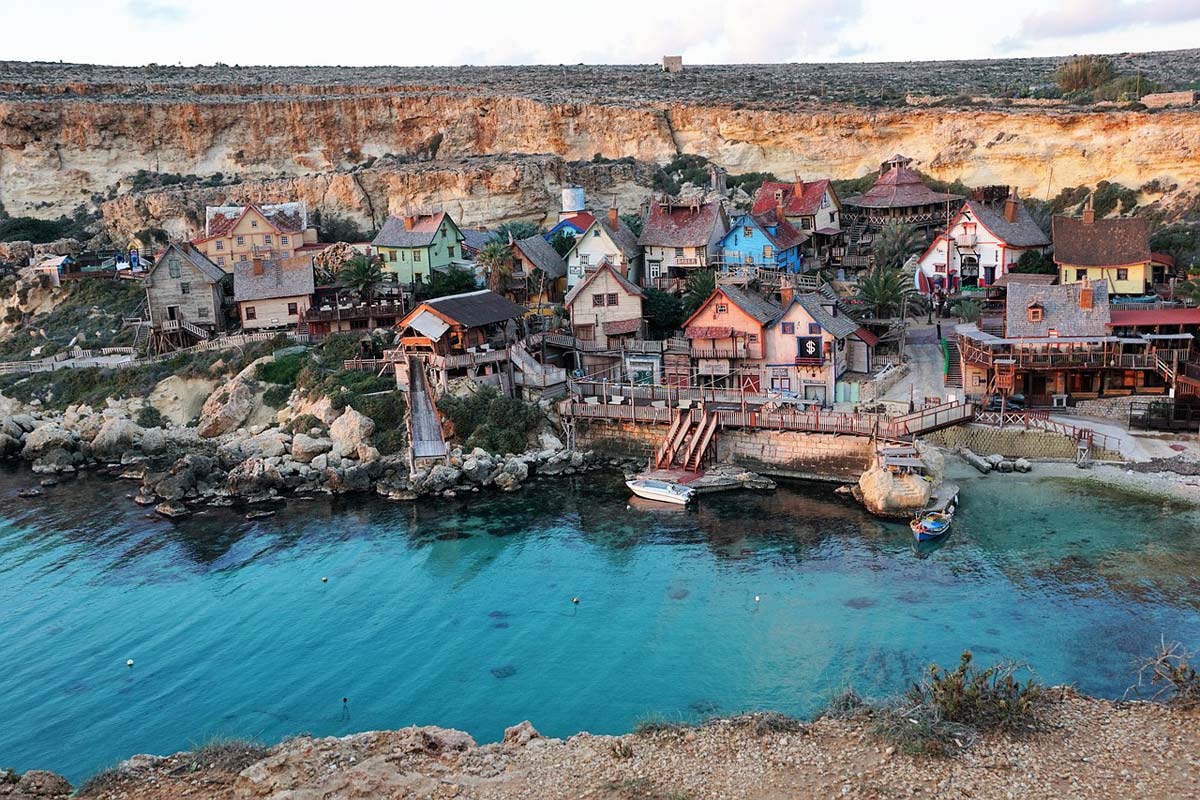
I put this point on the map only because it can be attractive for families with children. Popeye Village is an artificial creation, a town built in 1979 for the filming of the movie "Popeye". After the end of filming, Popeye's village was converted into a small amusement park, and it serves this function to this day.
If you are looking for entertainment for children, then this point may interest you. If you are looking for a different experience, a glance from the viewpoint is enough, because (as you can easily guess) the film crew chose the picturesque Anchor Bay as the location of the village.
Entrance tickets (2023):
- adults: EUR 14
- children: EUR 7
more information: on the Popeye Village website - [click]
Popeye - bus stop near Popeye Village
lines stop: 101
GPS coordinates of the stop:
35°57’39.4″N 14°20’32.7″E
35.960935, 14.342404 - click and route
Parking at the entrance to Popeye Village, GPS coordinates:
35°57’40.0″N 14°20’33.6″E
35.961116, 14.342666 - click and route
Parking at Popeye Village and Anchor Bay Lookout, GPS coordinates:
35°57’34.8″N 14°20’27.1″E
35.959675, 14.340873 - click and route
4.4 Golden Bay Beach (Ir-Ramla tal-Mixquqa)
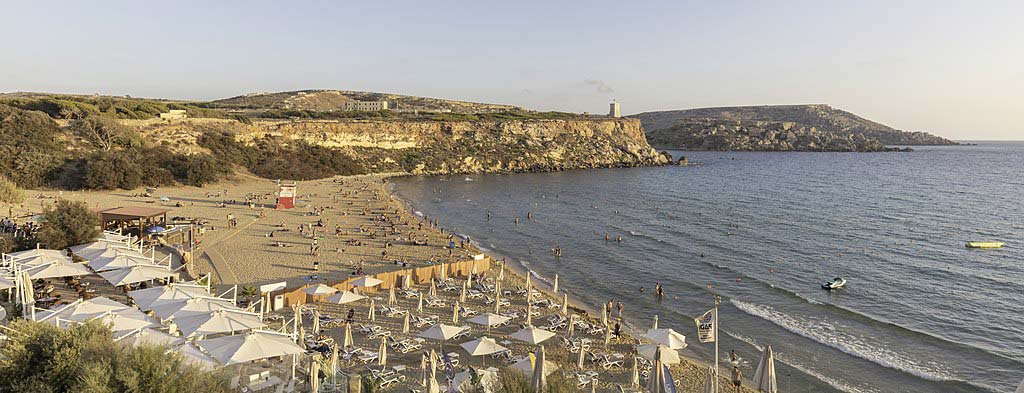
photo: Diego Delso on the rules CC BY-SA 4.0 Deed
Golden Bay (or simply Ir-Ramla tal-Mixquqa) is the largest and most famous sandy beach on the island. It is wide, extensive and has all the amenities: bars, restaurants, beach equipment rentals and everything you need to spend more than one whole day on it. Of course, it also has a large, guarded swimming area with a gently sloping bottom, thanks to which younger children have at their disposal a large coastal shallows. In the season, the beach attracts a lot of lovers of sunbathing and swimming in the water. Lovers of intimate peace and quiet must then stock up on patience or earplugs. At the peak of summer, despite the huge area on the beach, it can get crowded.
Fortunately, if the level of crowding or noise exceeds the level acceptable for you, you can go for an interesting walk in the immediate vicinity right from the beach. There are several paths leading to some really interesting viewpoints. It is from these points that beautiful, colorful photographs are often created that effectively lure tourists to Malta. It's worth taking a walk for these views.
Ghajn Tuffieha Bus Terminus - bus stop near Golden Bay
lines stop: 44
GPS coordinates of the stop:
35°56’05.2″N 14°20’46.4″E
35.934763, 14.346231 - click and route
Parking at Golden Bay, GPS coordinates:
35°56’04.3″N 14°20’40.8″E
35.934524, 14.344673 - click and route
4.5 Riviera Beach (Ghajn Tuffieha)
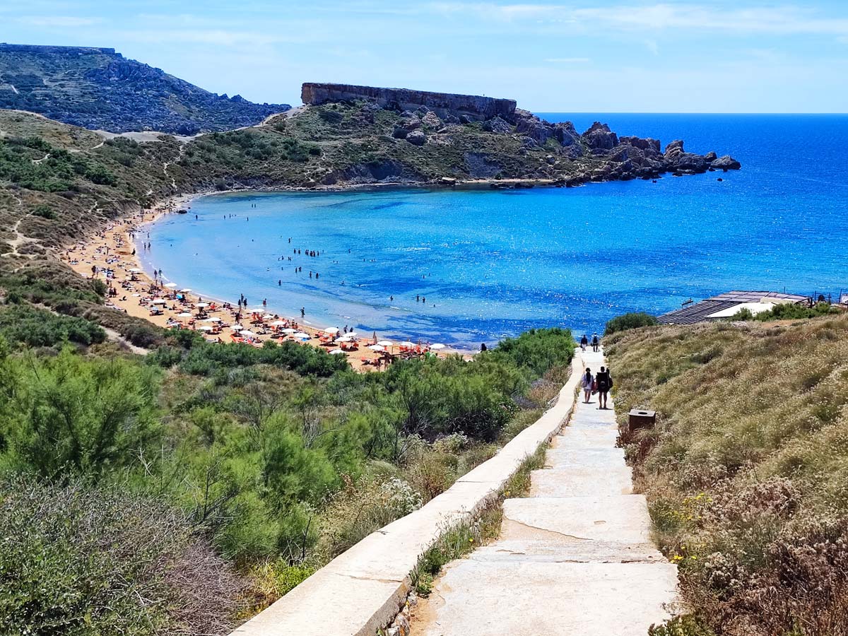
Located not far from Golden Bay, Riviera Beach (or simply Ghajn Tuffieha) is, in my subjective opinion, a more interesting choice. It is smaller, not as wide, but generates much less noise and crowds. At the same time, it is definitely more picturesquely located. Nestled in the surrounding hills, it creates a very pleasant atmosphere. Long and steep, but comfortable stairs lead from the nearby parking lot to the beach. The descent towards the beach is pleasant, but on the way back up some people will stop to catch their breath.
From Riviera Beach you can also go for a walk in the surrounding hills. Then new and beautiful views of picturesque hills and fabulously colorful bays open up in front of us. I recommend it even more because the walk is neither long nor overly tiring. The hills at Riviera Beach, due to their location, are a great place to admire the sunset.
By the beach you will also find a bar and restaurant (tested, great food!), beach equipment rental and toilets.
Unfortunately, the parking lot by the beach, although quite large, fills up very quickly. Then you have to combine with parking on the street.
Riviera - bus stop near Riviera Beach
lines stop: 44
GPS coordinates of the stop:
35°55’50.8″N 14°20’50.7″E
35.930770, 14.347420 - click and route
Parking at the descent to Riviera Beach, GPS coordinates:
35°55’51.1″N 14°20’45.9″E
35.930853, 14.346079 - click and route
4.6 Bridges
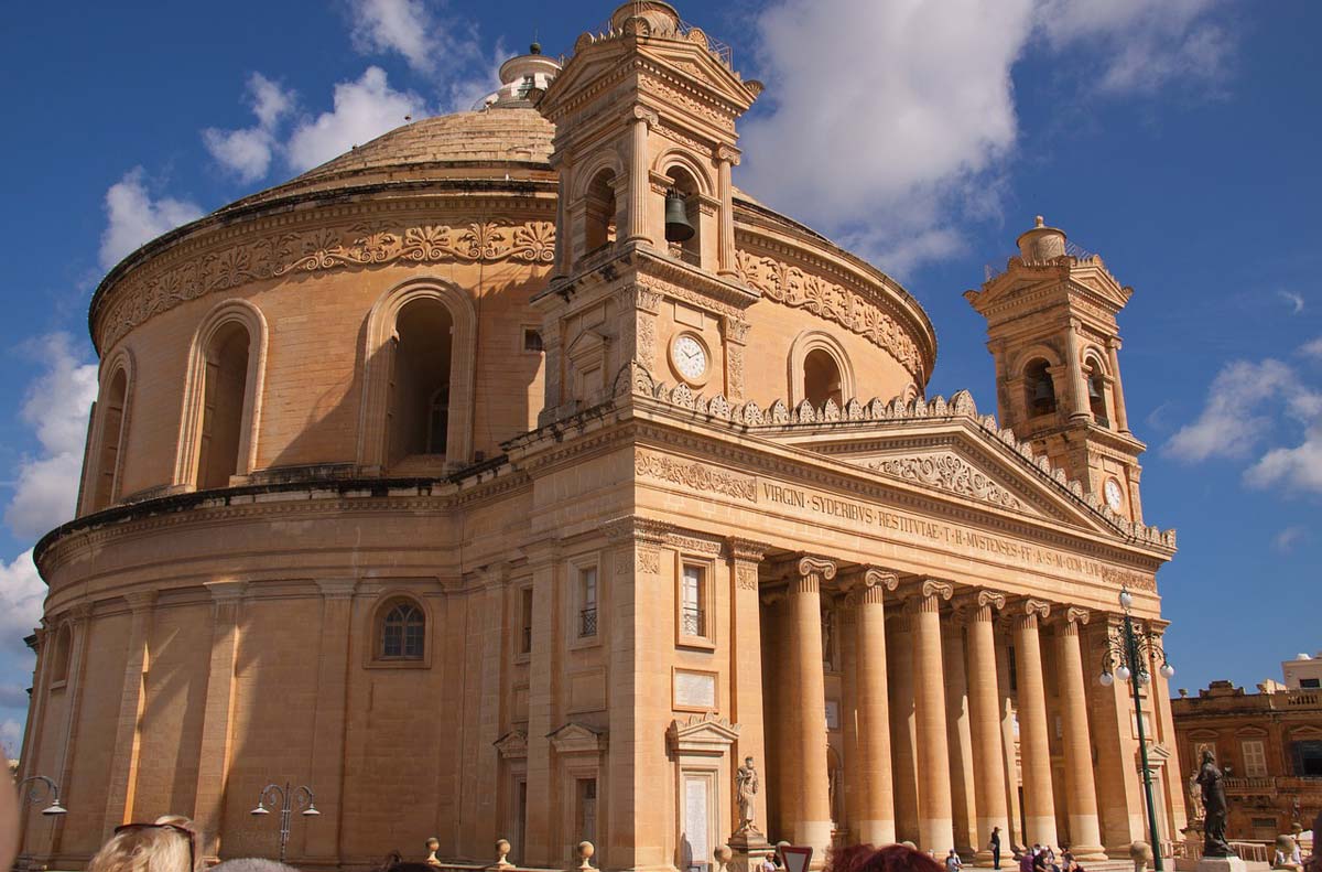
People come to Mosta mainly to admire one of the world's largest domes crowning the ceiling of the Sanctuary of the Assumption of the Mother of God, called the Rotunda in Mosta for short (The Mosta Dome). Statistics say that it is the third largest in Europe (after Florence and Wytkanie), and the ninth in the world.
The building was built based on the plans Pantheon in Rome and this resemblance immediately catches the eye. An interesting fact, which the inhabitants of Malta commonly call a miracle, is an event that took place during one of the countless bombings during World War II. The Luftwaffe units leading the raid dropped several bombs towards the Rotunda. One of them bounced off the roof of the Rotunda and fell to the ground next to the building, and the other pierced the dome and fell into the crowd of 300 people inside the building. Neither of the two bombs exploded. The bomb from inside the building was taken out, defused, and then dumped in the sea. Currently, the same model of the bomb is exhibited in the Rotunda, but it is not exactly the one that broke through the roof.
After the roof was reconstructed where the bomb hole had been, the ornamentation was deliberately not completely reconstructed, and indicates where the bomb hole used to be.
Rotunda in Mosta, GPS coordinates:
35°54’34.9″N 14°25’33.5″E
35.909706, 14.425970 - click and route
Nicola - bus stop near the Rotunda
lines stop: 47
GPS coordinates of the stop:
35°54’52.3″N 14°24’56.4″E
35.914513, 14.415653 - click and route
Parking at the Rotunda, GPS coordinates:
35°54’35.6″N 14°25’31.5″E
35.909894, 14.425413 - click and route
For the inquisitive:
Directly below the Rotunda, interesting shelters from World War II are available for sightseeing (you can buy a combined ticket to visit the rotunda and shelters), and about 1300 meters further you can find the Ta' Bistra Catacombs.
Ta' Bistra Catacombs, GPS coordinates:
35°54’55.6″N 14°24’58.5″E
35.915454, 14.416241 - click and route
Bistra - bus stop near the Ta' Bistra Catacombs
lines stop: 47
GPS coordinates of the stop:
35°54’52.3″N 14°24’56.4″E
35.914513, 14.415653 - click and route
Parking near the Ta' Bistra Catacombs, GPS coordinates:
35°54’55.5″N 14°24’58.0″E
35.915405, 14.416122 - click and route
4.7 Ta Hagrat megalithic temple
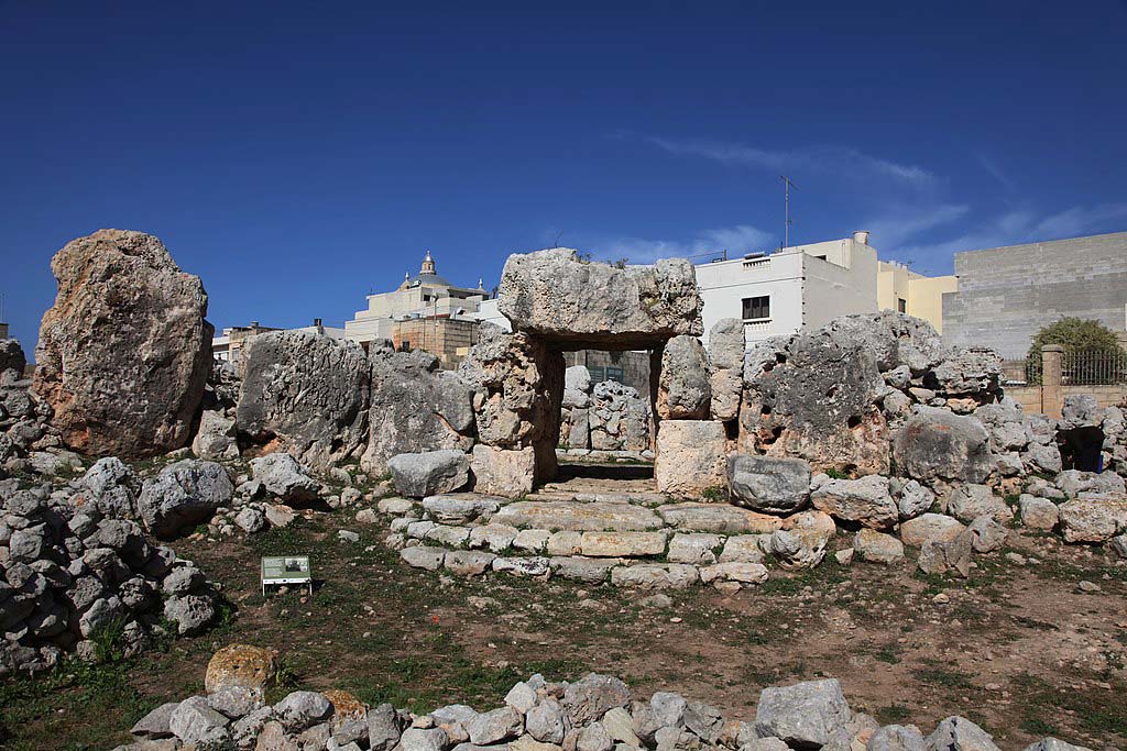
photo: Hans A. Rosbach on rules CC BY-SA 3.0
The megalithic temple of Ta Hagrat belongs to the group of several oldest known religious sites in the world (it is on the UNESCO list).
This Hagrat consists of two main parts:
– larger temple (3600 – 3200 BC)
– smaller temple (3300 – 3000 BC).
This means that it was built about 1000 years earlier than the pyramids in Egypt.
It is the best preserved megalithic temple in the northern part of the island. Better preserved temples can be found only in the southern part of Malta. Their descriptions can be found later in the text.
Ta Hagrat megalithic temple, GPS coordinates:
35°55’07.2″N 14°22’07.2″E
35.918672, 14.368658 - click and route
Teatrali - bus stop near the temple
lines stop: 44
GPS coordinates of the stop:
35°55’10.1″N 14°22’11.6″E
35.919466, 14.369888 - click and route
Parking on the street near the temple, GPS coordinates:
35°55’07.8″N 14°22’07.5″E
35.918827, 14.368752 - click and route
4.8 Megalithic Bugibba Temple
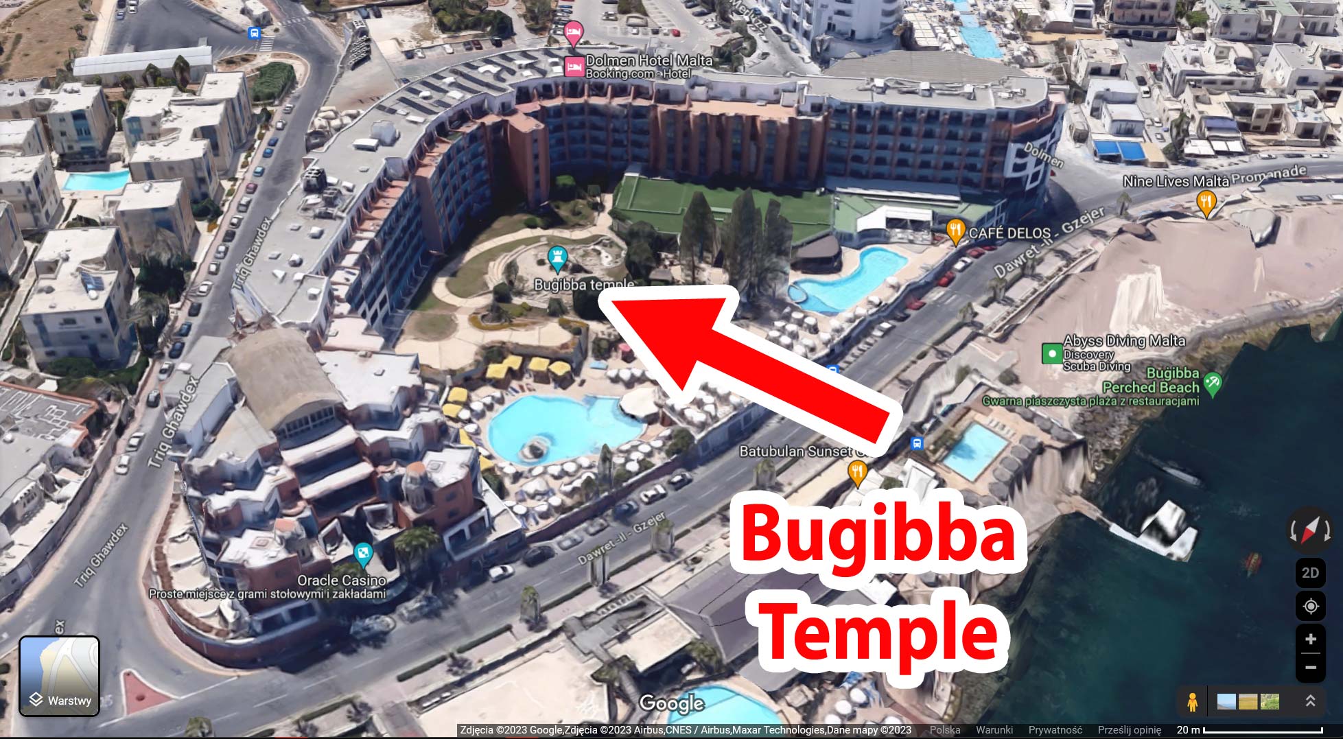
Source: Google Maps
I include the Bugibba Temple only as a curiosity, because its current location is very peculiar. Someone came up with the idea that due to the high attractiveness of the area, a hotel will be built in the place where the temple is located. And that's how it happened. The temple has been preserved, but it has become part of the equipment of a large hotel, which was built in the same place. Hotel guests going from their rooms to the pool pass through the temple, because it is located exactly between the exit of the building and the pool.
The megalithic Bugibba Temple on the hotel grounds Dolmen Hotel Malta – [click], GPS coordinates:
35°57’17.0″N 14°25’05.2″E
35.954720, 14.418110 - click and route
4.9 Victoria Lines or the Great Wall of Malta
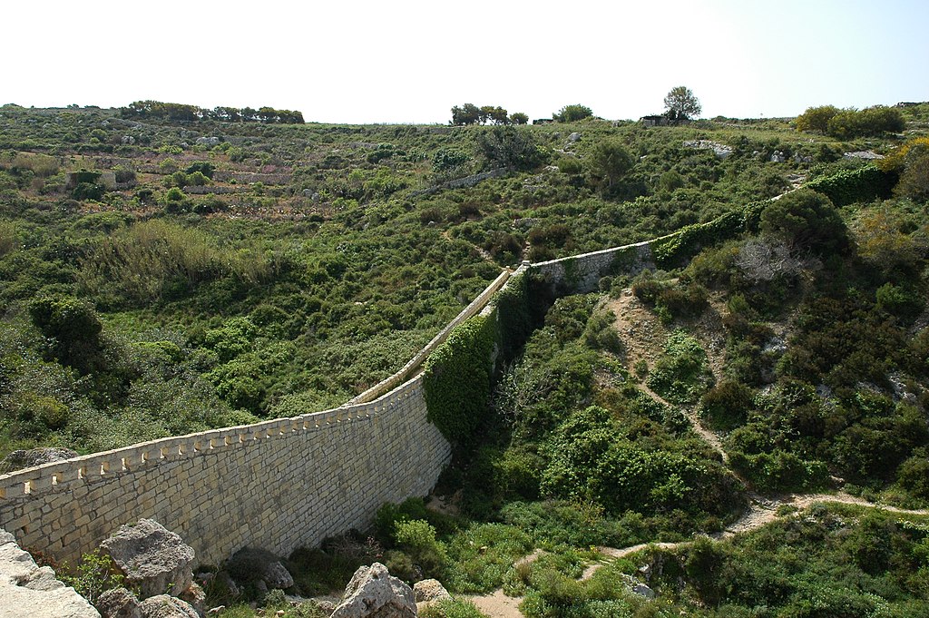
photo: Rolf Krahl on rules CC BY-SA 4.0
The Victoria Lines are sometimes called the Great Wall because in fact it is a wall and defensive fortifications that stretch across the entire island from the village of Baħar iċ-Ċagħaq near Swieqi (on the east of the island) to Fomm ir-Riħ Bay (on the west side of the island) .
The purpose of the wall was, of course, purely defensive and was to separate the populated, southern part of the island with the capital, which was then located in Mdnina, from the unpopulated northern part.
In this way, if the enemy broke into the island in its less protected, populated part, the wall protected the rest of the island from further expansion of the enemy.
In exactly the same place near the wall, there are two more interesting and basically "wild" historical objects:
– Phoenician, Punic and Roman tombs
– Paleo-Christian hypogeum
If you look closely, you'll see them for yourself. If that doesn't work, here are some helpful GPS coordinates.
The wall can be climbed ... but you will probably easily deal with it without my help 🙂
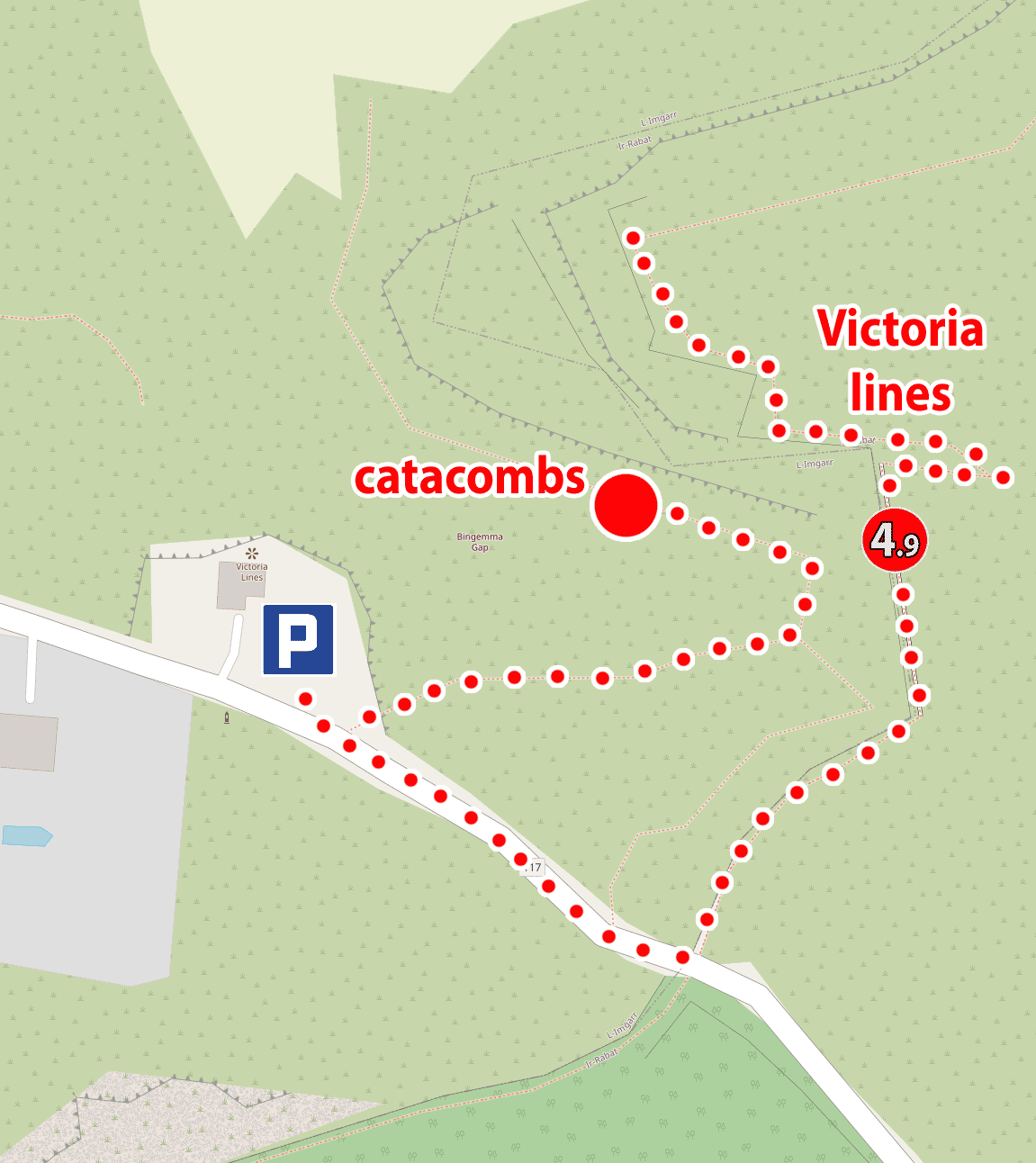
A landmark under the Victoria Lines Wall and close to Phoenician, Punic and Roman tombs and the Paleo-Christian Hypogeum, GPS coordinates:
35°54’12.2″N 14°22’42.7″E
35.903393, 14.378540 - click and route
Paleochristian hypogeum and Phoenician, Punic and Roman tombs, GPS coordinates:
35°54’13.5″N 14°22’42.0″E
35.903736, 14.378324 - click and route
Chapel parking and Victoria Lines viewpoint, GPS coordinates:
35°54’11.8″N 14°22’39.2″E
35.903272, 14.377552 - click and route
5.1 Dingli Cliffs
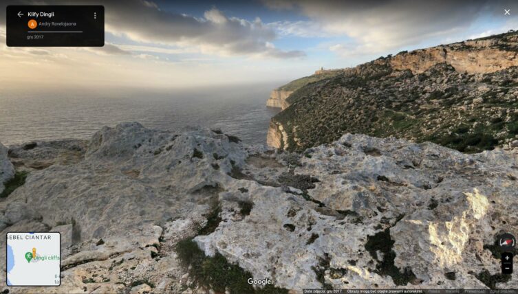
Clicking on the picture will take you to the panorama on Google maps
Source: Google Maps
Spectacular, 200 meters high and beautiful cliffs form part of the west coast of the island, but access to spectacular views is very limited. Below are the coordinates of two viewpoints between which you can walk along the path. Further views are available from the path, which are basically no different from what can be seen from the viewpoints. However, if you want to stretch your legs, this is a good opportunity.
I find the second view point to be more interesting.
The official viewpoint
Carruta - bus stop the “5x” zone line closest to the viewpoint. You have to walk to the point about 1,1 km or change to bus 201
stop lines: 52, 56, 201 (line connecting several areas)
GPS coordinates of the stop:
35°51’34.2″N 14°22’55.7″E
35.859506, 14.382149 - click and route
Maddalena - bus stop at the viewpoint of the Dingli Cliffs
lines stop: 201 (line connecting several areas)
GPS coordinates of the stop:
35°51’08.0″N 14°23’09.1″E
35.852208, 14.385852 - click and route
Car park at the Dingli cliffs viewpoint, GPS coordinates:
35°51’07.4″N 14°23’08.8″E
35.852061, 14.385782 - click and route
The second viewpoint
The second (more interesting) viewpoint on Dingli cliffs, GPS coordinates:
35°50’29.4″N 14°23’54.8″E
35.841506, 14.398548 - click and route
Zuta - bus stop by the path to the second viewpoint of the Dingli Cliffs
lines stop: 201 (line connecting several areas)
GPS coordinates of the stop:
35°50’40.1″N 14°23’56.8″E
35.844471, 14.399097 - click and route
A piece of dirt cove for short parking on the path to the second viewpoint of the Dingli Cliffs, GPS coordinates:
35°50’40.1″N 14°23’58.0″E
35.844460, 14.399434 - click and route
5.2 Mdina
In Maltese, the word “mdina” means: city. Mdina was founded by the Phoenicians (approximately in the 1530th century BC), over time it gained importance to eventually become the capital of the island. It lost its role only in XNUMX, when the Joannites arrived on the island and moved the capital first to Birgu and then to Valletta.
The role that Mdina has played for centuries meant that it consists almost exclusively of beautiful and spectacular buildings. The position of the capital made it obligatory.
Mdina is entirely surrounded by a powerful defensive wall, and you can only get inside through the city gates.
Currently, the entire area of Mdina is pedestrianized and you can only move around on foot inside the city. However, I recommend walking very slowly. The town is really small, you can even say pocket money and you will be able to walk around it in no time.
Time is spent here very pleasantly, mainly due to the pleasant silence and the scenery, which is created by beautiful buildings and narrow, stone streets. It is definitely a must-see on the trip.
The main gate to Mdina, GPS coordinates:
35°53’05.1″N 14°24’12.4″E
35.884746, 14.403439 - click and route
Mdina - bus stop near the main gate to Mdina
stop lines: 50, 51, 52, 53, 56, 201 (line connecting several areas)
GPS coordinates of the stop:
35°53’01.8″N 14°24’12.3″E
35.883822, 14.403425 - click and route
Public parking near the main gate to Mdina, GPS coordinates:
35°53’01.6″N 14°24’13.1″E
35.883785, 14.403637 - click and route
5.3 Discount
Now a riddle. If in Maltese the city is mdina, what will the suburbs be called? Of course you guessed it: discount. In Maltese, suburbs is "rabat". The town of Rabat in Malta is nothing more than a suburb of Mdina described in the previous point.
In Rabat, it is worth taking a walk through the narrow streets, which are decorated with beautiful balconies, colorful shutters, doors and knockers. Sacer can be combined with a visit to St. Paul, located under the Church of the Grotto of St. Paul and 250 meters further, very interesting Catacombs of St. Paul.
Basilica and Grotto of St. Paul, GPS coordinates (300 meters from the car park):
35°52’54.8″N 14°23’56.2″E
35.881879, 14.398943 - click and route
Catacombs of St. Paul, GPS coordinates:
35°52’49.8″N 14°23’51.1″E
35.880500, 14.397514 - click and route
5.4 Cart Ruts
forum: Bald on rules CC BY-SA 3.0
They are commonly known as trolley tracks or rock ruts, or simply in Maltese Misrah Ghar il-Kbir 🙂
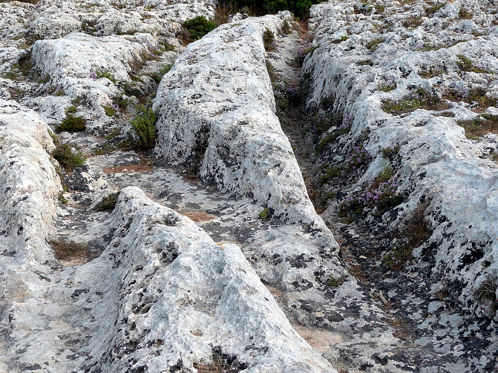
Until the end, it is still not known exactly when and how they were created and what they were used for. Research on them is still ongoing, and there are many hypotheses. The approximate dating of their creation, however, says that they were created at least 700 years before our era or even earlier. Some estimates even indicate dates up to 2500 - 3800 BC. Their depth reaches 60 cm, and (let's call it conventionally) the wheelbase is 110 - 140 cm.
According to most researchers, their formation is associated with a side effect of transport activities and the properties of the rock, which was soft and pliable here.
Observing the ruts brings to mind an association with a huge railway station, where the tracks (in this case, the ruts) sometimes connect to each other, and sometimes fork and cross.
My observations led me to a few other observations. If the ruts were caused by transport, it could not have been ordinary transport, but the transport of something really heavy (if ordinary transport caused such ruts, they would be everywhere on the island). The number of ruts indicates a considerable amount of traffic in this place. There are several such places with rock ruts on the island (e.g. near Busewdien, Naxxar, San Gwann or Bidnija), although the ones from which I started the description (Misrah Ghar il-Kbir) currently look the most spectacular. If you put on the map the location of places with rock ruts and places where megalithic temples are located, it turns out that they are close to each other. For example, the ruts of Misrah Ghar il-Kbir are only about 4 km to the Hagar Qim temple and from the Mnajdra temple. From the next rutting area in Busewdien, it is quite close to Ta Hagrat Temple (2,5 km) and Bugibba Temple (3,4 km).
If one were to compare the time intervals in which the temples were formed and the ruts may have been formed, it turns out that they also coincide well. And finally, one more observation. Right next to the ruts of Misrah Ghar il-Kbir there is ... a huge quarry (!!!). So someone recently noticed that this is a good place to get stone. So, if for us today this place seemed good to obtain stone, could not our ancestors come to the same conclusions? They were clever and very intelligent observers, and they felt the nature on which they directly depended without a doubt better than us. So, could the ruts have arisen as a result of increased transport and handling of the mined stone, intended for the nearby construction of temples?
Misrah Ghar il-Kbir rock rut area, GPS coordinates:
35°51’10.4″N 14°23’49.2″E
35.852900, 14.396997 - click and route
Buskett - bus stop near the main gate to Mdina
lines: 52, 56 stop
GPS coordinates of the stop:
35°51’18.5″N 14°23’38.6″E
35.855149, 14.394057 - click and route
Small parking space near the rock ruts, GPS coordinates:
35°51’15.5″N 14°23’47.6″E
35.854310, 14.396548 - click and route
7.1 Blue Grotto
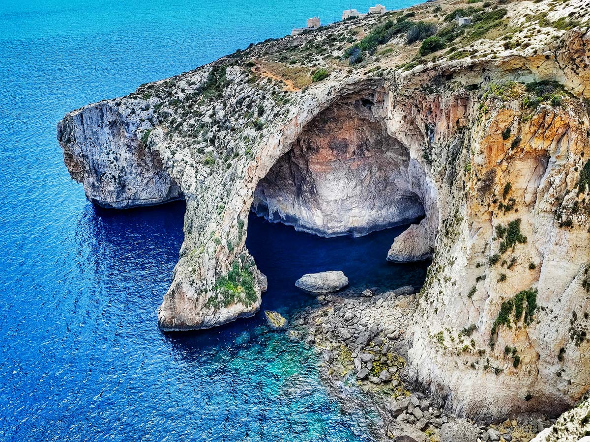
The Blue Grotto is one of Malta's most famous natural wonders. If you sometimes look at different photos on the internet, Blue Grotto looks really beautiful on them. And how is it really? Exactly the same! There is no exaggeration in these photos. The fantastic rock formation looks great against the blue water, creating a stunning view that is easily accessible to see from a specially prepared vantage point.
If you feel like it, for EUR 10 (price from spring 2023) you can go on a boat trip lasting several dozen minutes. During the cruise you will visit several sea caves and swim under the Blue Grotto leg visible from the viewpoint.
From the vantage point to the marina from which the boats depart, you have to go down a few hundred meters along the asphalt road. At the end of the road there is a large car park, a small settlement with restaurants, bars and shops and a boat dock.
Panorama - bus stop at the viewpoint on the Blue Grotto
lines stop: 74, 201 (line connecting several areas)
GPS coordinates of the stop:
35°49’20.7″N 14°27’26.7″E
35.822429, 14.457415 - click and route
A small car park at the Blue Grotto viewpoint, GPS coordinates:
35°49’21.5″N 14°27’27.4″E
35.822644, 14.457622 - click and route
Harbor for boats - cruises to Blue Grotto, GPS coordinates:
35°49’12.1″N 14°27’06.0″E
35.820015, 14.451658 - click and route
Grotto - bus stop on cruises to Blue Grotto
lines stop: 74
GPS coordinates of the stop:
35°49’10.3″N 14°27’14.0″E
35.819514, 14.453893 - click and route
Ample parking on Blue Grotto cruises, GPS coordinates:
35°49’11.0″N 14°27’14.0″E
35.819720, 14.453883 - click and route
7.2 Hagar Qim Megalithic Temple
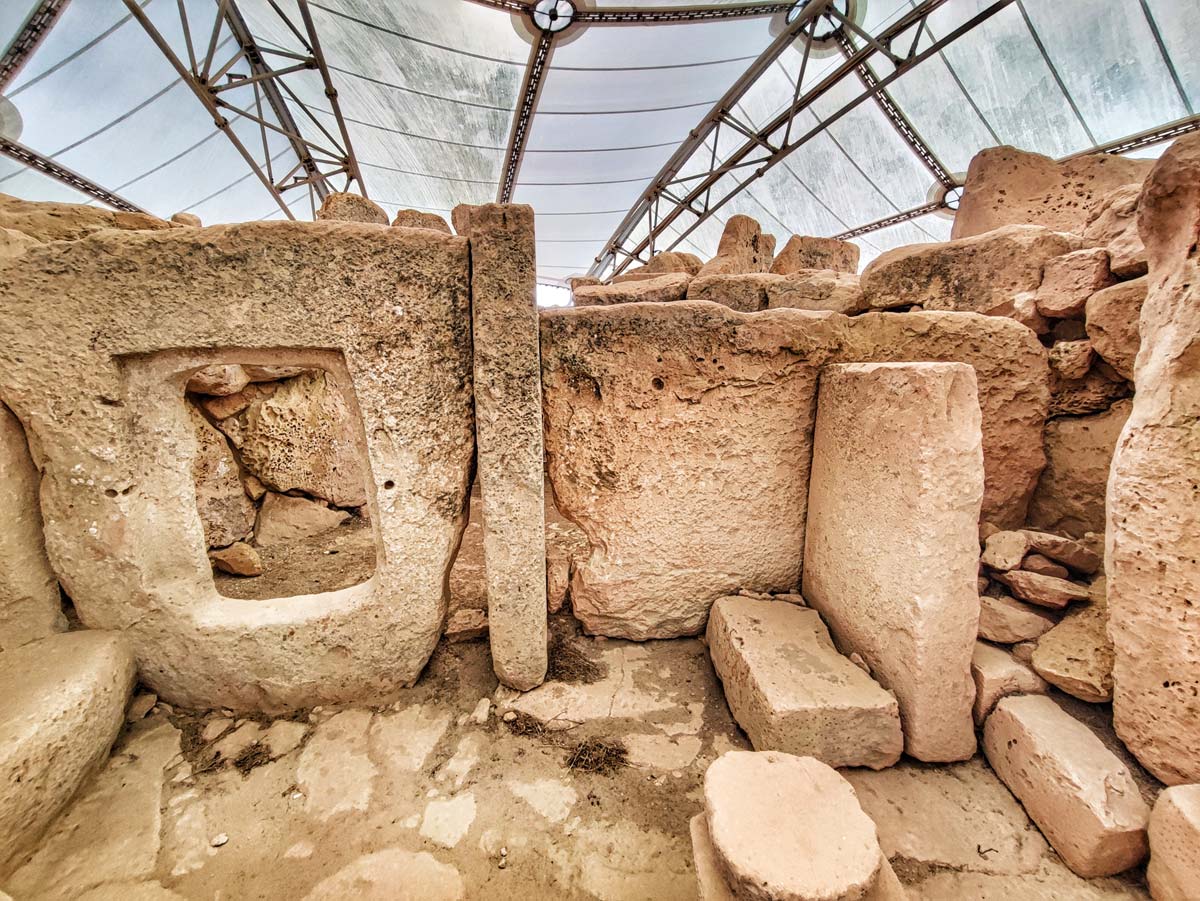
Hagar Qim Temple is one of the two best-preserved megalithic temples in Malta. It is one of the most important monuments on the island and at the same time one of the most important religious monuments in the world. Like the previously described Ta Hagrat, it was built about 5500 years ago (3600 - 3200 BC) and is one of the oldest temples on Earth.
Walking around the temple, pay attention to the two largest monoliths used in its construction. The largest is 3 meters high, 6 meters wide and weighs about 20 tons. The second largest vertical menhir is 5 meters high.
During the summer solstice, direct sunlight enters one of the apses through a small opening. This only happens for a short while during sunrise.
The temple, of course, is on the UNESCO list.
Hagar Qim Megalithic Temple, GPS coordinates:
35°55’07.2″N 14°22’07.0″E
35.918656, 14.368624 - click and route
Hagar - bus stop at Hagar Qim Archaeological Park
lines stop: 74, 201 (line connecting several areas)
GPS coordinates of the stop:
35°49’38.9″N 14°26’44.6″E
35.827460, 14.445719 - click and route
Hagar Qim archaeological park parking lot, GPS coordinates:
35°49’38.7″N 14°26’37.6″E
35.827420, 14.443789 - click and route
If there is no space in front of the building of the archaeological park, then another parking lot is on the other side of the building (you have to go around the building).
7.3 Mnajdra megalithic temple
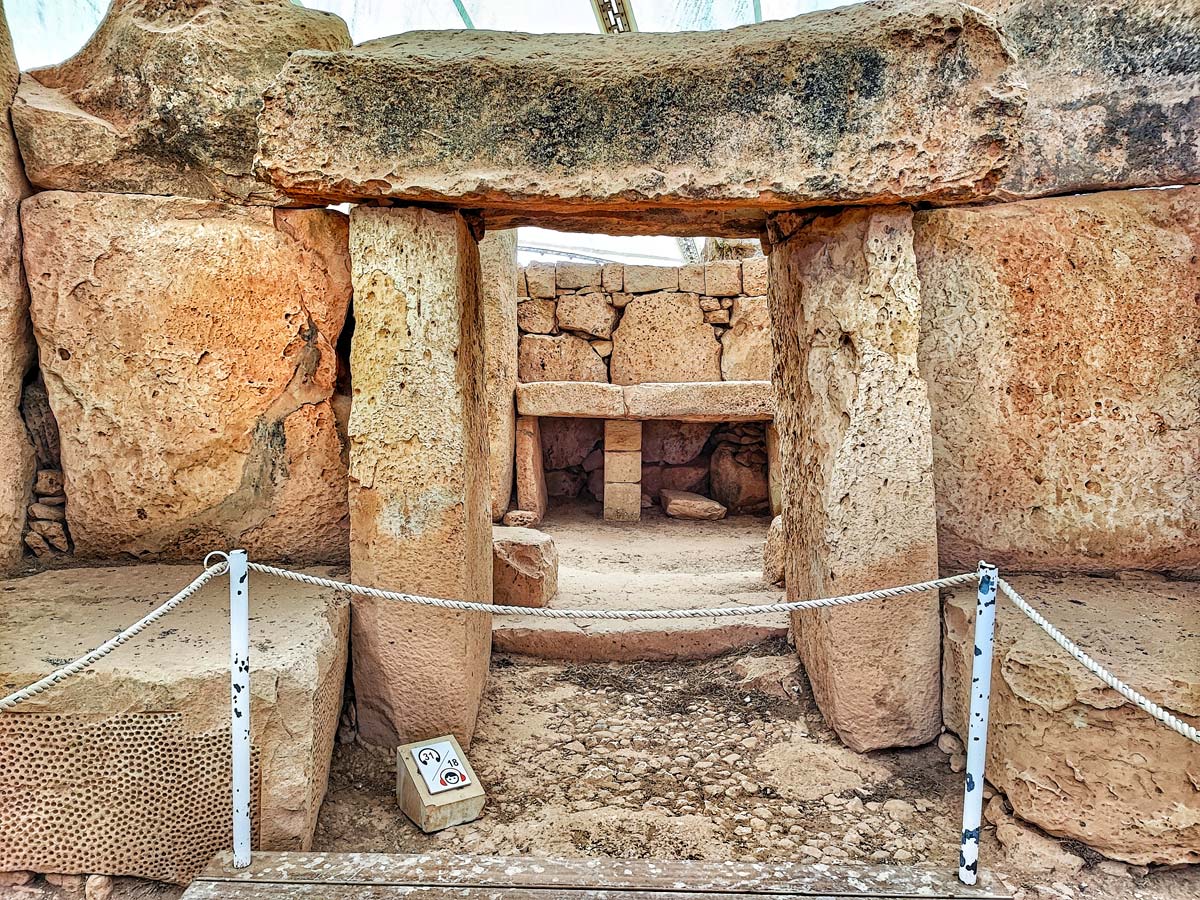
The second of the best-preserved megalithic temples (Mnajdra temple) is located right next to the previous one. They are only 300 meters apart and can be visited in one go (same admission ticket applies).
Mnajdra is basically a complex of three temples glued together, built between 3600 and 2500 BC.
When standing in front of the temples, you will have the oldest on the right, and the youngest is the lowest and farthest to the left. The construction of the youngest of the temples was planned so that at different times of the year its interior was properly illuminated by the sun's rays:
– the altar to the right of the entrance is illuminated at sunrise during the winter solstice
– the altar on the left in the back room is illuminated by sunlight at sunrise during the summer solstice
Needless to say, Mnajdra is also on the UNESCO list.
The entrance to Mnajdra i and Haġar Qim (7.2) is shared, so the bus, stop and car park are the same.
8.1 Hal Saflieni Hypogeum
Another Maltese site on the UNESCO list is the Hal Saflieni Hypogeum. Somewhat surprisingly, the exact purpose of the hypogeum is not really known to this day. It was founded 2500 years BC and originally probably served as a sanctuary, and then it was transformed into a necropolis. After the hypogeum was made available for sightseeing, it turned out that it is very popular, and crowds of tourists threaten the rock paintings discovered in the hypogeum. In 1992, the facility was closed and for the next eight years, work was carried out on the appropriate preparation of security measures, allowing the facility to be opened to the public. In the year 2000, the hypogeum can be visited again, but the number of tourists has been limited to 80 people per day (!!!). Tourists are admitted in groups of 10 people and there are only 8 entrances each day. You have to take care of tickets in advance, buying them preferably 2-3 months in advance.
check out: tickets to Hypogeum Hal Saflieni – [click]
The hypogeum has three levels. The lowest level reaches 14 meters underground. Internal corridors, niches, chambers, lobbies, steps and remnants of wall paintings have survived intact to this day.
A short official video (30 seconds long) with some snapshots from inside the hypogeum is below:
Hal Saflieni Hypogeum, GPS coordinates:
35°52’09.9″N 14°30’25.0″E
35.869409, 14.506941 - click and route
Pjazza - bus stop near Hypogeum Hal Saflieni
lines: 81, 82, 83, 84, 88 stop
GPS coordinates of the stop:
35°52’15.2″N 14°30’26.1″E
35.870885, 14.507247 - click and route
Small car park near Hypogeum Hal Saflieni, GPS coordinates:
35°52’16.4″N 14°30’25.8″E
35.871221, 14.507173 - click and route
8.2 Tarxien Temples
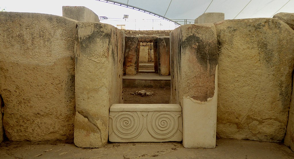
photo: Ethan Doyle Whiten on rules CC BY-SA 4.0
Tarxiem is another of the megalithic temples inscribed on the UNESCO list. They are very close to Valletta, so they are really easy to reach. The complex of temples is divided into three main, separate (some divide into 5), but interconnected parts, the oldest of which was founded around 3500 BC.
Particularly interesting here are clearly visible bas-reliefs depicting domestic animals, altars and patterns of decorations (usually spiral).
The research of the temple proves that it was particularly often used for animal sacrifices.
Tarxien temples, GPS coordinates:
35°52’08.3″N 14°30’40.2″E
35.868984, 14.511178 - click and route
Neolitici - bus stop near the Temples of Tarxien
lines: 81, 82, 84, 85, 88 stop
GPS coordinates of the stop:
35°52’03.7″N 14°30’40.5″E
35.867698, 14.511262 - click and route
Parking your car near the Tarxien Temples is very difficult as it is only possible in the adjacent streets. There is no typical parking here, It would be best if you could park in the parking lot I gave at the Hypogeum Hal Saflieni. Then you can see both attractions without moving your car, because they are close to each other (about 500 meters apart).
8.3 Marsaxlokk
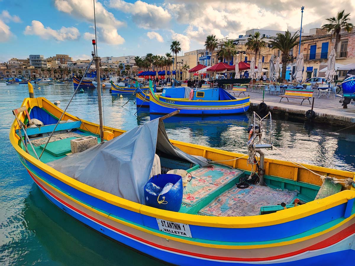
The popularity of Marsaxlokk was mainly due to the colorful boats called Pizzeriawhich are moored in large numbers in the bay. The entire surface of the bay is filled with them, and the vivid colors in which boats are traditionally painted make for a perfect scenery in which tourists love to take pictures.
In the town, every Sunday there is a traditional market, which attracts a huge number of tourists. The market has a traditional look and feel only in the morning (around 7am) before the crowds from all over the island arrive. Then there is fresh fish from the morning catch and there are no souvenir stalls yet. Later, the stalls with souvenirs and other well-selling gadgets open up, then the market loses its true character and becomes a typical tourist market.
Waterfront with restaurants in Marsaxlokk, GPS coordinates:
35°50’25.2″N 14°32’40.6″E
35.840328, 14.544596 - click and route
Marsaxlokk - stop bus station in the center of the town
lines stop: 81
GPS coordinates of the stop:
35°50’27.7″N 14°32’42.3″E
35.841020, 14.545082 - click and route
Free, ample parking in Marsaxlokk, GPS coordinates:
35°50’26.3″N 14°32’49.7″E
35.840651, 14.547135 - click and route
8.4 Ghar Dalam Cave
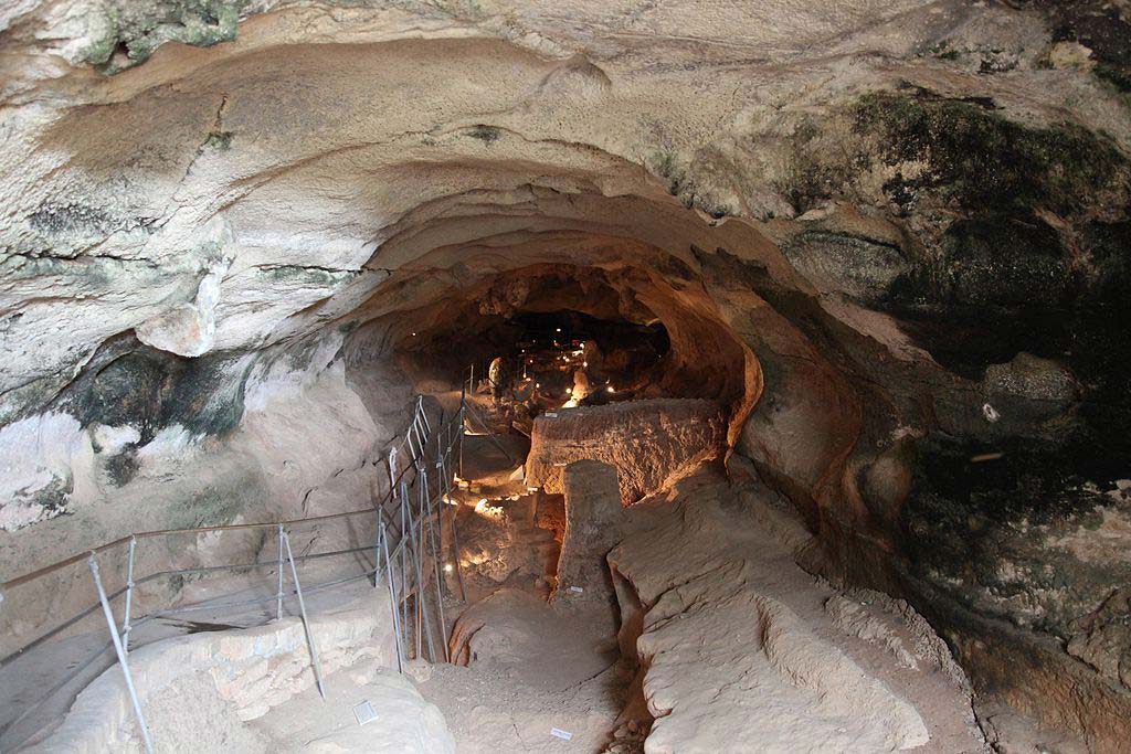
photo: Frank Vincentz on rules CC BY-SA 3.0
The Ghar Dalam cave is mainly known for the oldest traces of human presence on Mata, dating back to 5 BC. A lot of animal bones were also discovered here that ... never lived in Malta 🙂
This find has still not been clearly explained and scientists are still looking for a solution to this mystery.
Entrance to Ghar Dalam Cave, GPS coordinates:
35°50’09.6″N 14°31’39.3″E
35.835987, 14.527575 - click and route
Ghar Dalam Cave - bus stop near the cave
lines: 80, 82 stop
GPS coordinates of the stop:
35°50’12.9″N 14°31’42.2″E
35.836908, 14.528395 - click and route
Parking at Ghar Dalam Cave, GPS coordinates:
35°50’13.0″N 14°31’40.7″E
35.836949, 14.527962 - click and route
9.1 Marsaskala salt pans
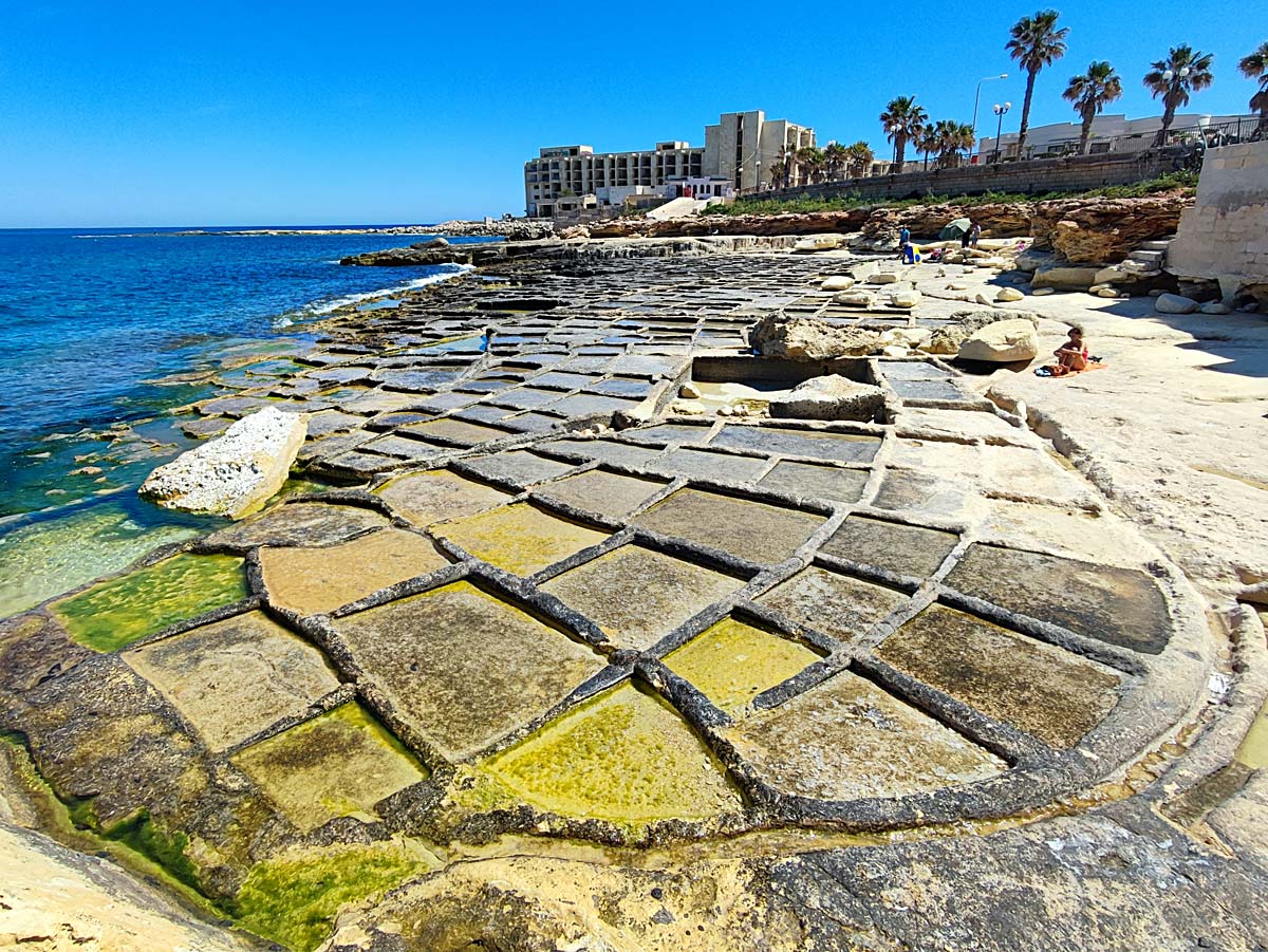
It is well known that people go to Gozo to see the salt pans. Slightly less common is the information that equally beautiful salt pans can also be found in Malta. Therefore, I decided to supplement and disseminate this information, especially important for those who cannot or simply do not go to Gozo. It's a pity to miss such a chance, because the pans in Malta are as beautiful as those in Gozo. More details can be found in the post: Salt pans in Malta - access and sightseeing - [click]
Salt pans in Marsaskala, GPS coordinates:
35°51’51.1″N 14°34’16.8″E
35.864182, 14.571340 - click and route
Olivana - bus stop near the salt pans in Marsaskala
lines stop: 93
GPS coordinates of the stop:
35°51’48.0″N 14°34’18.8″E
35.863339, 14.571882 - click and route
Street parking next to the salt pans in Malta, GPS coordinates:
35°51’51.7″N 14°34’14.1″E
35.864365, 14.570570 - click and route
9.2 Beach and Bay of St. thomas
One of the less known and popular, but amazing beaches. Definitely worth visiting both by those who want to sunbathe and by those who do not plan to lie on the beach. In the rankings of the most beautiful beaches, it is often overlooked, but it beats most of those that are constantly recommended in the rankings.
I recommend a separate post about it: Beach and Bay of St. Thomas - [click]
Cliff and Beach Thomas, GPS coordinates:
35°51’26.1″N 14°34’14.0″E
35.857256, 14.570550 - click and route
Parking in a cul-de-sac by the beach, GPS coordinates:
35°51’28.9″N 14°34’10.6″E
35.858024, 14.569616 - click and route
Malta - additional attractions and activities
In Malta, in addition to the typical places to visit, you can do quite a lot of other activities related to swimming, diving, tethered parachute flying, trips on shores, etc.
I will not include any specific examples here, because the offer is constantly changing and developing. Instead, I will post a link that will take you to a page that collects all currently available offers in one place. The link prepared by me automatically filters and rejects offers not related to our topic.
check out: interesting activities for tourists in Malta – [click]
Malta - hotels and accommodation
The choice of where to look for a hotel depends on what you intend to do on the island. Below I will provide a few links, as usual, containing filters, limiting the results to a given location and the immediate vicinity. I will illustrate some links with screenshots presenting the appearance of specific hotels.
The hotels I propose should not be treated as the only and recommended ones. Treat them rather as a proposal from which it is worth starting your search, because the search engine, in addition to the object selected by me, will also offer you several other, very similar objects. Probably in this way you will quickly find a good offer at a good price.
Hotel for active sightseeing by rented car
Here the situation is the simplest. You basically have the whole island at your disposal and you can choose a hotel wherever you like. You can get everywhere by car, and my sightseeing plan is prepared so that no matter where you live, you will not be in danger of making unnecessary kilometers for empty journeys. The car rental option is definitely the most convenient and gives the greatest freedom in choosing accommodation and implementing the sightseeing plan.
An interesting option is to plan, for example, two days on Gozo. Then you spend part of your time in Malta and part in Gozo.
A few hotel suggestions from which you can start your search can be found below.
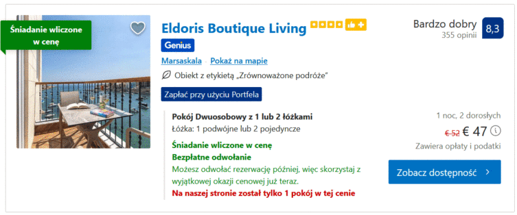
Eldoris Boutique Living – [click]
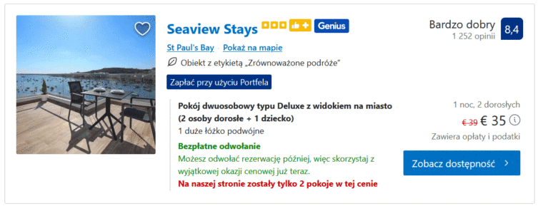
Seaview Stays – [click]
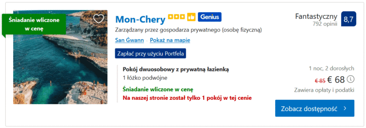
Mon-Chery – [click]
Hotel for sightseeing by bus
In this case, it will be most convenient to live so that within a short walk you have the main bus stop in Valletta, where most buses leave. So, mainly places near Valletta come into play. Of course, you can live outside of Valletta, but then bus travel will become much more burdensome. It may end up like mine. With relief after two days I rented a car and continued exploring the island by car.
A few examples of accommodation near Valletta, where you can start your search, can be found below. Click and choose.
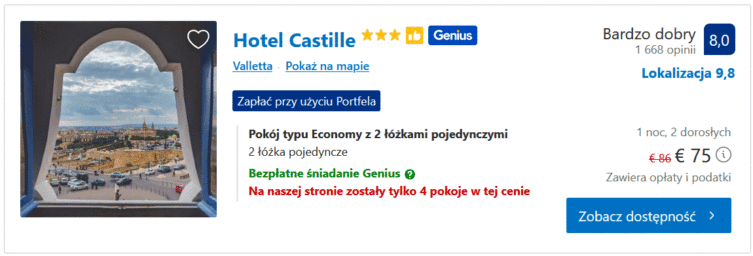
Hotel Castille – [click]
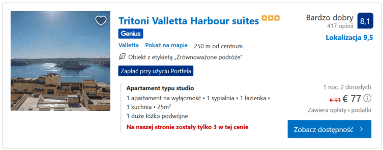
Tritoni Valletta Harbor suites – [click]
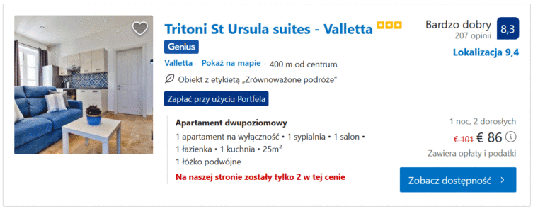
Tritoni St Ursula suites – [click]
A hotel for a lazy holiday
If you are going for a typical lazy holiday, then look for a hotel somewhere outside of Valletta, near an interesting beach that you will be happy to use. You will have to drive there when you arrive, but as you know, the island is well connected and unless the flight is late in the evening or at night, you can get anywhere.
check out: accommodation hotels near San Gorg beach – [click]
check out: accommodation and hotels near Paul's Bay – [click]
check out: accommodation and hotels in Marsaskala – [click]
check out: accommodation and hotels in Birzebbuga – [click]
Important to me!
Give the article a good rating (5 stars welcome 😀)!It's free, a for me it is very important! The blog lives on visits and thus has a chance to develop. Please do it and ... thank you in advance!
If you like my guides, you will certainly find the one I created useful guide catalog - [click]. There you will find ready-made ideas for your next trips, descriptions of other tourist destinations and an alphabetical list of guides divided into countries, cities, islands and geographical regions.
I also post link to Facebook profile - [click]. Come in and press "Follow"then you will not miss new, inspiring posts.
Unless you prefer Instagram. I'm not a social media demon, but you can always count on something nice to look at on my instagram profile - [click]. The profile will gladly accept any follower who likes it.
I make the content I create available free of charge with copyright, and the blog survives from advertising and affiliate cooperation. So, automatic ads will be displayed in the content of the articles, and some links are affiliate links. This has no effect on the final price of the service or product, but I may earn a commission for displaying ads or following certain links. I only recommend services and products that I find good and helpful. Since the beginning of the blog's existence, I have not published any sponsored article.
Some of the readers who found the information here very helpful, sometimes ask me how you can support the blog? I do not run fundraisers or support programs (type: patronite, zrzutka or "buy coffee"). The best way is to use links. It costs you nothing, and support for the blog is self-generating.
Pozdrawiam

Thanks, great job!
Important informations, compactly prepared,
Uli
Hey, we will be a pram with a one year old. Which of the following attractions are impossible or difficult to get to with a small child?
Generally, you can reach everywhere, but I recommend taking a baby carrier with you. Then you will enter everywhere.
Thank you for the great description. I'm going to Malta at the turn of February and March. Your description was very helpful.
Agnieszka
Super professional, very helpful. Great appreciation
Hats off for preparing such material. I am grateful to. Thank you very much.
Very interesting description :)
My question is whether a person without knowledge of English will be able to cope? Or does traveling there make no sense then?
I thought I understood something, but they were babbling so much that I had no idea what they were saying. However, a few basic phrases will be needed (in a hotel, restaurant, ticket office, etc.).
Hello,
In the part about visiting Northern Malta by double-decker buses, you provide a link to purchase tickets. When I clicked, I see trips from Sliema, and you write that the first stop is from Bugibba (Topaz hotel). This would suit me because we will be staying in Qawra palace hotel resort (I can get to the Topaz hotel by regular bus), but where should I buy tickets then? I'm 70 years old and I need to know everything exactly. . Please call me on WhatsApp +48 ——— I will be obliged.
Regards, Małgorzata
Good morning,
You can also buy a ticket directly on the bus (if there are free seats).
If something is not in my entry, you can find more details directly on the HO-HO bus website – [click]
Hello, how is it in Malta and Gozo with renting electric bikes?
Hello,
I haven't explored this topic much.
I can tell you that (probably) the largest bike rental company on the island is located near Saint Paul's Bay, and is called EKO SPORTS – [click] <--- here is a link to their website
Warm thanks and great appreciation for professionalism, accuracy and insight into the prepared material. Extremely helpful and comprehensive information, useful in many ways.
Everything 6*
great post, thank you!
Jacek, thank you very much for this guide. We have just returned from Malta, the sightseeing of which was based on your entry (so we missed the promised post about Valletta and Birg!) We made small modifications, but the most valuable for us were the points - links to parking lots at attractions (we had a car). We also traveled around Gozo with your tips and here we did it from AdoZ. We stayed at Comino for too long and one day turned into two (in November, the day ends on the 17th, so it's harder to fit everything in and your plans are quite intense). We managed to see most of the sights and spend some time on the beach and swimming in the sea (priceless in November!)
In our subjective opinion, there are quite a few megalithic temples, but they are similar, we were not impressed by the ruts at all (by the way, there are also some at the foot of Fort St. Angelo), Popeye was enough for us to have a look from the viewpoint. We added Peter's pool, which is worth seeing in my opinion.
Irmina, first of all, thank you for your comments!
I'll catch up on Valetta and Birgu (it's little consolation for you, because you've already been there). Definitely St. I should add Peter's Pool to the list.
Best wishes
When can we expect this promised post about Valletta and Birg?
I'm leaving in a week and a half :)
Oh no, I won't make it! Time deficit.
St Peter's Pool beats the ruts and the cave here 😉 and maybe it's worth mentioning to other visitors to Malta that tickets to the temples and the cave (and some other attractions) can be purchased as a combo ticket and the price is more favorable.
Wonderful blog. Everything is described in detail. I am impressed with the amount of information :) We are going to Malta in mid-December. And your blog is a 10 (or even 100!) hit. Everything in one place.
It's just like us. I'm a bit concerned about the weather, but we'll see
I'm impressed! Lots of information in one place, thank you very much! I feel prepared for the trip, the sightseeing plan has just been formed.
Thank you very much for your very detailed and valuable tips. We are flying for the first time for 4 days and thanks to you I know how to plan our stay.
Thanks again 🙂
Thank you for the complete compendium of information,
I'm currently planning a week's stay in Malta. Many thanks for your valuable tips!
Thanks Jacek
I'm going to Malta with a friend on March 6 for a week. I have been studying your tips with interest. When I return, I will let you know how much they helped us. Regards
A well-prepared entry, thank you, I benefited greatly from the trip! I will add that there are direct X2 and TD2 buses from the airport to Sliema. You can get off at the Ferry3 stop.
Thank you Jacek, very well done and certainly helpful , I 'm going to Malta in 10 days..
Not sure to rent a car, even if it must be more interesting..
Hope the buses will be ok!
Virginia
The best Malta guide I've ever seen! Great respect for your work and for sharing it with us. I bow to the ground 🙂
Ti ringrazio di cuore. E' la prima volta che trovo tanto aiuto e davvero esposto in modo eccellente.